Sigi Regency
| Sigi Regency Kabupaten Sigi | ||
|---|---|---|
| Regency | ||
| ||
| Coordinates: 1°23′06″S 119°58′01″E / 1.38500°S 119.96694°E | ||
| Country | Indonesia | |
| Province | Central Sulawesi | |
| Capital | Sigi Biromaru | |
| Government | ||
| • Regent | Muhammad Irwan Lapata | |
| • Vice Regent | Paulina | |
| Area | ||
| • Total | 5,196.02 km2 (2,006.19 sq mi) | |
| Population (2010) | ||
| • Total | 215,030 | |
| • Density | 41/km2 (110/sq mi) | |
| Time zone | UTC+8 (ICST) | |
| Area code | (+62) 451 | |
| Website |
sigikab | |


Sigi Regency is a regency of Central Sulawesi, Indonesia. It lies upstream on the Palu River, and immediately south of Palu city, the provincial capital. The principal town lies at Sigi Biromaru.

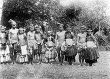
Prince and princess of Kulawi
Marego dancers in Kulawi

Woman in traditional dress in Kulawi
Administration
The Sigi Regency was divided at 2010 into fifteen districts (kecamatan), tabulated below with their areas and their 2010 Census populations.[1]
| Name | Area in sq.km | Population Census 2010 |
|---|---|---|
| Pipikoro | 977.74 | 7,817 |
| Kulawi Selatan (South Kulawi) | 431.86 | 8,473 |
| Kulawi | 1,077.72 | 14,172 |
| Lindu | 577.87 | 4,690 |
| Nokilalaki | 75.33 | 5,626 |
| Palolo | 645.72 | 27,385 |
| Gumbasa | 201.27 | 11,682 |
| Tanambulava | 58.44 | 7,866 |
| Dolo Selatan (South Dolo) | 583.52 | 14,448 |
| Dolo Barat (West Dolo) | 91.06 | 12,576 |
| Dolo | 56.11 | 20,591 |
| Sigi Biromaru | 304.17 | 42,857 |
| Marawola | 38.66 | 20,991 |
| Kinovaro | 60.34 | 9,474 |
| Marawola Barat (West Marawola) | 166.46 | 6,382 |
References
- ↑ Biro Pusat Statistik, Jakarta, 2011 & 2016.
Regencies and cities of Central Sulawesi | ||
|---|---|---|
Capital: Palu | ||
| Regencies | ||
| City | ||
Coordinates: 1°23′06″S 119°58′01″E / 1.38500°S 119.96694°E
This article is issued from
Wikipedia.
The text is licensed under Creative Commons - Attribution - Sharealike.
Additional terms may apply for the media files.