Philippine Sea Plate
| Philippine Sea Plate | |
|---|---|
 | |
| Type | Minor |
| Approximate area | 5,500,000 km2[1] |
| Movement1 | north-west |
| Speed1 | 48-84mm/year |
| Features | Northern Luzon, Philippine Sea, Taiwan |
| 1Relative to the African Plate | |
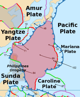
The Philippine Sea Plate or Philippine Plate is a tectonic plate comprising oceanic lithosphere that lies beneath the Philippine Sea, to the east of the Philippines. Most segments of the Philippines, including northern Luzon, are part of the Philippine Mobile Belt, which is geologically and tectonically separate from the Philippine Sea Plate.
Philippine Sea plate is bordered mostly by convergent boundaries[2]:
To the north, the Philippine Sea Plate meets the Okhotsk Plate at the Nankai Trough. The Philippine Sea Plate, the Amurian Plate, and the Okhotsk Plate meet at Mount Fuji in Japan. The thickened crust of the Izu-Bonin-Mariana arc colliding with Japan constitutes the Izu Collision Zone.
To the east, Philippine Sea Plate meets the Pacific Plate, subducting at the Izu-Ogasawara Trench. The east of the plate includes the Izu-Ogasawara (Bonin) and the Mariana Islands, forming the Izu-Bonin-Mariana Arc system. There is also a divergent boundary between the Philippine Sea Plate and the small Mariana Plate which carries the Mariana Islands.
To the south, the Philippine Sea Plate is bounded by the Caroline Plate and Bird's Head Plate.
To the west, the Philippine Sea Plate subducts under the Philippine Mobile Belt at the Philippine Trench and the East Luzon Trench. (The adjacent rendition of Prof. Peter Bird's map is inaccurate in this respect.)
To the northwest, the Philippine Sea Plate meets Taiwan and the Nansei islands on the Okinawa Plate, and southern Japan on the Amurian Plate.
.jpg)
See also
References
- ↑ "Sizes of Tectonic or Lithospheric Plates".
- ↑ Smoczyk, G.M., Hayes, G.P., Hamburger, M.W., Benz, H.M., Villaseñor, Antonio, and Furlong, K.P., 2013, Seismicity of the Earth 1900–2012 Philippine Sea Plate and vicinity: U.S. Geological Survey Open-File Report 2010–1083-M, scale 1:10,000,000, https://dx.doi.org/10.3133/ofr20101083m.
- Hall, Robert; Fuller, Michael; Ali, Jason R.; Anderson, Charles D. (1995). "The Philippine Sea Plate' Magnetism and Reconstructions" (PDF). American Geophysical Union. Retrieved October 9, 2014.
External links
- High-resolution map of Tectonic Plate Boundaries
- Map showing Seismicity of the Earth, 1900‒2012: Philippine Sea Plate and Vicinity United States Geological Survey