Torfaen
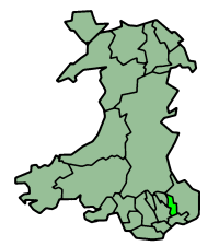
Torfaen is een unitaire autoriteit in het zuiden van Wales, gelegen in het ceremoniële behouden graafschap Gwent en het historische graafschap Monmouthshire. De county borough heeft 93.000 inwoners.
 | |||
| Coördinaten | 51°41'55,08049"NB, 3°3'12,49178"WL | ||
| Algemeen | |||
| Oppervlakte | 125,6987’[1] km² | ||
| Inwoners | 93049 (2018)[2] (740 inw./km²) | ||
| Grootste plaats | Cwmbran | ||
| Bestuurlijke status | county borough | ||
| Welsh sprekend | 14,5% | ||
| Overig | |||
| ISO 3166-2 | GB-TOF | ||
| ONS-code | W06000020 | ||
| Officiële website | torfaen.gov.uk | ||
| |||
Plaatsen
- Blaenavon
- Cwmbran (fungeert als het bestuurlijke centrum van het aangrenzende bestuurlijke graafschap Monmouthshire)
- Pontypool
Bronnen, noten en/of referenties
|
| Bestuurlijke indeling van het Verenigd Koninkrijk: principal areas van Wales | |
|---|---|
|
Graafschappen: Anglesey · Carmarthenshire · Ceredigion · Denbighshire · Flintshire · Gwynedd · Monmouthshire · Pembrokeshire · Powys County boroughs: Blaenau Gwent · Bridgend · Caerphilly · Conwy · Merthyr Tydfil · Neath Port Talbot · Rhondda Cynon Taf · Torfaen · Vale of Glamorgan · Wrexham Steden: Cardiff · Newport · Swansea Zie ook: behouden graafschappen (preserved counties) en de historische graafschappen | |
This article is issued from
Wikipedia.
The text is licensed under Creative
Commons - Attribution - Sharealike.
Additional terms may apply for the media files.