Hawaii (island)
Hawaiʻi (Hawaiian pronunciation: [həˈvɐjʔi]) anglicized Hawaii (/həˈwaɪ.i/ (![]()
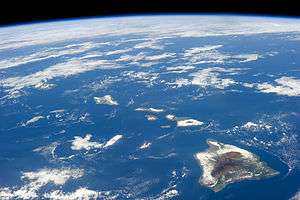
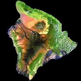 Landsat mosaic, 1999–2001 | |
.svg.png) Location in the state of Hawaii | |
| Geography | |
|---|---|
| Location | 19°34′N 155°30′W |
| Archipelago | Hawaiian Islands |
| Area | 4,028 sq mi (10,430 km2) |
| Area rank | 75th, largest island in the United States – 1st |
| Highest elevation | 13,803 ft (4,207.2 m)[1] |
| Highest point | Mauna Kea |
| Administration | |
United States | |
| State | Hawaii |
| Symbols | |
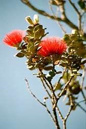
| Flower | Red Pua Lehua (ʻOhiʻa blossom)[2] |
| Color | ʻUlaʻula (red) |
| Largest settlement | Hilo |
| Demographics | |
| Population | 185,079 (2010) |
| Pop. density | 46/sq mi (17.8/km2) |
The island is often referred to as the Island of Hawaiʻi,[4] the Big Island, or Hawaiʻi Island to distinguish it from the state. Administratively, the whole island encompasses Hawaiʻi County.
As of the 2010 Census the population was 185,079.[5] The county seat and largest city is Hilo. There are no incorporated cities in Hawaiʻi County (see List of counties in Hawaii).[6]
History
Hawaiʻi is said to have been named after Hawaiʻiloa, the legendary Polynesian navigator who first discovered it. Other accounts attribute the name to the legendary realm of Hawaiki, a place from which some Polynesian people are said to have originated, the place where they transition to in the afterlife, or the realm of the gods and goddesses. Captain James Cook, the English explorer and navigator who was captain of the first European expedition that discovered the Hawaiian Islands, called them the "Sandwich Islands" after his patron, the Earl of Sandwich.[7] Cook was killed on the Big Island at Kealakekua Bay on 14 February 1779, in a mêlée which followed the theft of a ship's boat.[8]
Hawaiʻi was the home island of Paiʻea Kamehameha, later known as Kamehameha the Great. Kamehameha united most of the Hawaiian islands under his rule in 1795, after several years of war, and gave the kingdom and the island chain the name of his native island.[9] In 1822 the missionary William Ellis arrived and was one of a party that completed a tour of the island, descriptions of which were later published in his journal.[10]
Geology and geography
According to the U.S. Census Bureau, the county has a total area of 5,086 square miles (13,170 km2), of which 4,028 square miles (10,430 km2) is land and 1,058 square miles (2,740 km2) (20.8%) is water.[11] The county's land area comprises 62.7 percent of the state's land area. It is the highest percentage by any county in the United States.[12]
At its greatest dimension, the island is 93 miles (150 km) across. It has a land area of 4,028 square miles (10,430 km2)[13] comprising 62% of the Hawaiian Islands' land area. Measured from its sea floor base to its highest peak, Mauna Kea is the world's tallest mountain, taller than even Mount Everest, since the base of Mount Everest is above sea level.[14]
Ka Lae, the southernmost point in the 50 states of the United States, is on Hawaii. The nearest landfall to the south is in the Line Islands. To the northwest of the island of Hawaii is the island of Maui, whose Haleakalā volcano is visible from Hawaiʻi across the Alenuihaha Channel.

Volcanism
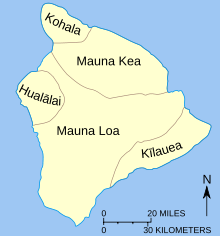
The island of Hawaiʻi is built from five separate shield volcanoes that erupted somewhat sequentially, one overlapping the other. These are (from oldest to youngest):[15]
- Kohala – extinct
- Mauna Kea – dormant
- Hualālai – dormant
- Mauna Loa – active, partly within Hawaiʻi Volcanoes National Park
- Kīlauea – active: erupting continuously from 1983 to 2018; part of Hawaiʻi Volcanoes National Park
Geological evidence from exposures of old surfaces on the south and west flanks of Mauna Loa led to the proposal that two ancient volcanic shields (named Ninole and Kulani) were all but buried by the younger Mauna Loa.[16] Geologists now consider these "outcrops" to be part of the earlier building of Mauna Loa.
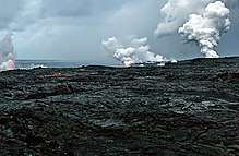
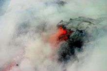
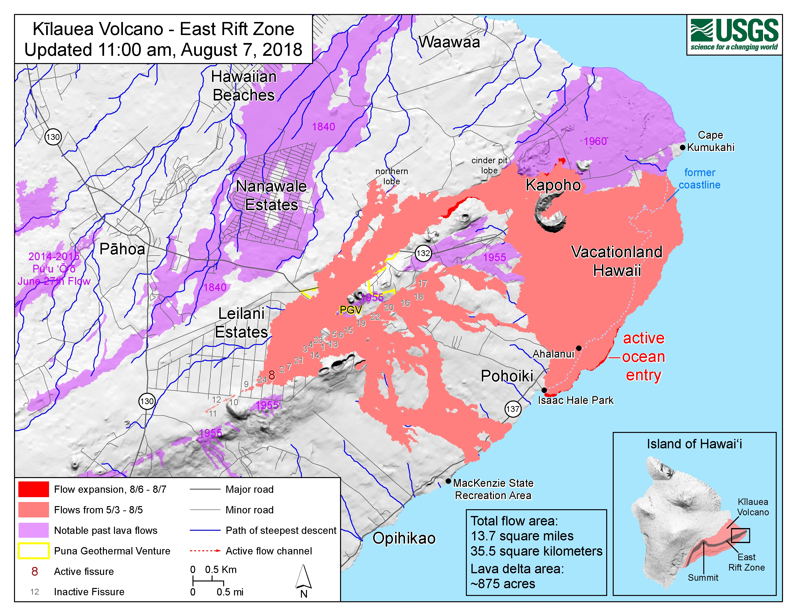
Because Mauna Loa and Kīlauea are active volcanoes, the island of Hawaii is still growing. Between January 1983 and September 2002, lava flows added 543 acres (220 ha) to the island. Lava flowing from Kīlauea has destroyed several towns, including Kapoho in 1960, and Kalapana and Kaimū in 1990. In 1987 lava filled in "Queen's Bath", a large, L-shaped, freshwater pool in the Kalapana area. Another 875 acres were added between May to July, 2018 by the 2018 lower Puna eruption.[17][18]
Some geologists count seven volcanoes as building the island, which include the submarine volcanoes Māhukona and Lōʻihi as parts of the base of the island.[19] Māhukona off the northwest corner of the island has already disappeared below the surface of the ocean.[20] Approximately 22 miles (35 km) southeast of Hawaii lies the undersea volcano known as Lōʻihi. It is an erupting seamount that now reaches approximately 3,200 feet (980 m) below the surface of the ocean. Continued activity at current rates from Lōʻihi will likely cause it to break the surface of the ocean sometime between 10,000 and 100,000 years from now.[21]
Great Crack
The Great Crack is an eight-mile-long (13,000 m), 60-foot-wide (18 m) and 60-foot-deep (18 m) fissure in the island, in the district of Kau. According to the United States Geological Survey (USGS), the Great Crack is the result of crustal dilation from magmatic intrusions into the southwest rift zone of Kilauea.[22] While neither the earthquake of 1868 nor that of 1975 caused a measurable change in the Great Crack, lava welled out of the lower 6 miles (10 km) of the Great Crack in 1823.[22]
Visitors can find trails, rock walls, and archaeological sites from as old as the 12th century around the Great Crack. Approximately 1,951 acres (790 ha) of private land were purchased during the presidency of Bill Clinton, specifically to protect various artifacts in this area, as well as the habitat of local wildlife.
Hilina Slump
_Hawaii_Christmas.jpg)
The Hilina Slump is a 4,760-cubic-mile (19,800 km3) section of the south slope of the Kīlauea volcano which is slipping away from the island. Between 1990 and 1993, Global Positioning System (GPS) measurements showed a southward displacement of about 4 inches (10 cm) per year.[23] Undersea measurements show that a "bench" has formed a buttress and that this buttress may tend to reduce the likelihood of future catastrophic detachment.[24][25]
Earthquakes and tsunamis
On 2 April 1868, an earthquake with a magnitude estimated between 7.25 and 7.9 rocked the southeast coast of Hawaiʻi. This was the most destructive earthquake in the recorded history of Hawaiʻi.[26] It triggered a landslide on Mauna Loa, 5 miles (8 km) north of Pahala, killing 31 people. A tsunami claimed 46 more lives. The villages of Punaluʻu, Nīnole, Kawaʻa, Honuʻapo, and Keauhou Landing were severely damaged. The tsunami reportedly rolled over the tops of the coconut trees up to 60 feet (18 m) high, and it reached inland a distance of a quarter of a mile (400 meters) in some places.[27]
On 29 November 1975, a 37-mile-wide (60 km) section of the Hilina Slump dropped 11.5 feet (3.5 m) and slid 26 feet (7.9 m) toward the ocean. This movement caused a 7.2 magnitude earthquake and a 48-foot-high (15 m) tsunami. Oceanfront property was washed off its foundations in Punaluu. Two deaths were reported at Halape, and 19 other people were injured.[28]
The island suffered tsunami damage from earthquakes in Alaska on 1 April 1946, and in Chile on 23 May 1960. Downtown Hilo was severely damaged by both tsunamis, with many lives lost. Just north of Hilo, Laupāhoehoe lost 16 schoolchildren and five teachers in the tsunami of 1946.[29]
In March 2011, a 9.0 magnitude earthquake off the east coast of Japan again created a tsunami that caused minor damage in Hawaiʻi. The estimated damage to public buildings alone was about US$3 million.[30] In the Kona area this tsunami washed a house into Kealakekua Bay, destroyed a yacht club and tour boat offices in Keauhou Bay, caused extensive damage in Kailua Kona, flooded the ground floor of the King Kamehameha Hotel,[31] and permanently closed the Kona Village Resort.[32]
In early May 2018, hundreds of small earthquakes were detected on Kīlauea's East rift zone, leading officials to issue evacuation warnings. On 3 May 2018, the volcano erupted in Puna after a 5.0 earthquake earlier in the day, causing evacuations of the Leilani Estates and Lanipuna Gardens subdivisions.[33][34] A seemingly related 5.3 magnitude quake and a subsequent 6.9 magnitude earthquake occurred on 4 May.[35][36]
Volcanic fog
.jpg)
Vog (volcanic fog) can envelop the island of Hawaiʻi when Kilauea Volcano is active. Since the termination of volcanic activity in September 2018, the vog has largely disappeared on the west side of the island.[37] The gas plumes of the Kīlauea Volcano create a blanket of vog which the dominant trade winds mostly deflect toward the Kona coast on the west side of the island of Hawaiʻi. Vog contains chemicals that can damage the environment and the health of plants, humans, and other animals. Most of the aerosols are acidic and of a size where they can remain in the lungs to damage them and impair function. Flu-like symptoms and general lethargy are reported, and are especially pronounced in people with respiratory conditions.[38][39][40][41]
National protected areas
- Ala Kahakai National Historic Trail
- Hakalau Forest National Wildlife Refuge
- Hawaiʻi Volcanoes National Park
- Honokōhau Settlement and Kaloko-Honokōhau National Historical Park
- Kohala Historical Sites State Monument (Mookini Heiau)
- Kona Forest National Wildlife Refuge
- Puʻuhonua o Hōnaunau National Historical Park
- Puʻukoholā Heiau National Historic Site
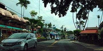 Downtown Kona
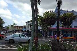 Downtown Hilo
Economy
Sugarcane was the backbone of the island of Hawaiʻi's economy for more than a century. In the mid-20th century, sugarcane plantations began to downsize, and in 1995 the last plantation closed.[42]
Most of the island's economy is based on tourism, centered primarily in resort areas on the western coast of the island in the North Kona and South Kohala districts. More recently, Hawaiʻi Island has become a focus for sustainable tourism.
Diversified agriculture is a growing sector of the economy. Major crops include macadamia nuts, papaya, flowers, tropical and temperate vegetables, and coffee beans. Only coffee grown in the Kona District of this island may be branded Kona coffee. The island's orchid agriculture is the largest in the state, and resulted in the unofficial nickname "The Orchid Isle". The island is home to one of the United States' largest cattle ranches: Parker Ranch, on 175,000 acres (708 km2) in Waimea. The island is also known for astronomy, with numerous telescopes operated on the summit of Mauna Kea, where atmospheric clarity is excellent and there is little light pollution.
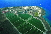
NELHA (Natural Energy Laboratory of Hawaii Authority), a 675-acre (273 ha) state developed site, is a green economic development ocean science and technology park on the west side of the island. It provides resources and facilities for energy and ocean-related research, education, and commercial activities in an environmentally sound and culturally sensitive manner. Business tenants on this coastal site include microalgae farms, aquaculture, solar technology and marine biotech. Tenants have access to three sets of pipelines delivering deep-sea water from a depth of up to 3,000 feet (910 m), as well as pristine sea surface water and almost constant sunshine. A 2012 study by the University of Hawaiʻi Economic Research Organization (UHERO) found the total economic impact of activities at NELHA was $87.7 million and created 583 jobs.[43]
Transportation
Roads
Three routes connect the two major towns, Hilo on the east coast and Kailua-Kona on the west coast of the island:[44]
- State highways 19 & 190, the northern route via Waimea
- State highway 11, the southern route via Hawaiʻi Volcanoes National Park
- Saddle Road (aka the Daniel K. Inouye Memorial highway), passing between Mauna Loa and Mauna Kea).
There are also State highways 270 (Kawaihae – Hawi) and 180 (the "Kona coffee road", from Honalo to State highway 190), South Point Road (Highway 11 to South Point), etc.
There are presently three Hawaii Scenic Byways on the island of Hawaii:
- Mamalahoa Kona Heritage Center
- Royal Footsteps Along the Kona Coast
- Kaʻu Scenic Byway – The Slopes of Mauna Loa
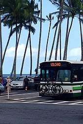
Rental car offices are at the international airports. Taxi service is also available. Island-wide bus service is provided by the "Hele-On Bus".[45]
Airports
Two commercial airports serve Hawaiʻi Island:
- Hilo International Airport (ITO)
- Kona International Airport (KOA)
There is also:
- Waimea-Kohala Airport (MUE)
- Upolu Airport (UPP)
Seaports
Major commercial ports are Hilo on the east side and Kawaihae on the west side of the island. Cruise ships often stop at Kailua-Kona (90 times in 2017)[46] and Hilo (108 times in 2017).[47]
Tourism
Places of interest
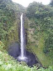
- Akaka Falls, one of the tallest waterfalls on the island.
- Amy B. H. Greenwell Ethnobotanical Garden houses many endangered endemic plants.
- East Hawaiʻi Cultural Center
- Hawaiʻi Tropical Botanical Garden
- Hawaiʻi Volcanoes National Park, comprising the active volcanoes Kīlauea and Mauna Loa
- Huliheʻe Palace, a royal palace in Kailua-Kona
- ʻImiloa Astronomy Center of Hawaiʻi in Hilo
- Ka Lae, the southernmost point in the United States
- Laupāhoehoe Train Museum
- Lyman House Memorial Museum in Hilo
- Manuka State Wayside Park
- Mauna Kea Observatories
- Nani Mau Gardens
- Onizuka Center for International Astronomy
- Pacific Tsunami Museum overlooking Hilo Bay
- Pana'ewa Rainforest Zoo in Hilo
- Pua Mau Place Arboretum and Botanical Garden
- Puʻuhonua o Hōnaunau National Historical Park
- Puʻukoho'ā Heiau National Historic Site, the site of one of the most significant heiau in Hawaiʻi
- Rainbow Falls State Park
- Sadie Seymour Botanical Gardens
- Umauma Falls
- University of Hawaiʻi at Hilo Botanical Gardens
- Waipiʻo Valley
- Wao Kele o Puna
- World Botanical Gardens
Hotels on the east coast
The larger hotels on the east coast are:
- Grand Naniloa Hotel, Hilo
- Hilo Hawaiian Hotel
- Volcano House, Kīlauea
Hotels on the west coast
The larger hotels on the west coast, from north (Puako) to south (Captain Cook):
- Mauna Kea Beach Hotel
- Westin Hapuna Beach Resort
- The Fairmont Orchid
- Hilton Waikoloa Village
- Waikoloa Beach Marriott
- Four Seasons Resort Hualalai
- King Kamehameha's Kona Beach Hotel
- Royal Kona Resort
- Sheraton Kona Resort & Spa at Keauhou Bay
- Manago Hotel
Maps
 National parks, mountains and cities on the island
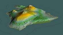
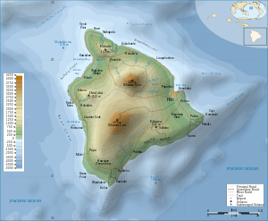 Topographic map of the island of Hawaii
See also
- National Register of Historic Places listings on the island of Hawaiʻi
References
- "Summit USGS 1977". NGS data sheet. U.S. National Geodetic Survey. Retrieved 18 August 2010.
- "Hawaii Island Flower – Red Pua Lehua (ʻOhiʻa blossom)". statesymbolsusa.org. State Symbols USA. 31 July 2012. Archived from the original on 2 August 2012. Retrieved 3 August 2012.
- "List of the Islands of Polynesia". Archived from the original on 1 January 2017.
- According to the Geographic Names Information System, Island of Hawaiʻi is the preferred name, see U.S. Geological Survey Geographic Names Information System: Island of Hawaiʻi.
- "State & County QuickFacts". United States Census Bureau. Archived from the original on 13 July 2011. Retrieved 28 June 2014.
- Geography, US Census Bureau. "2010 Geographic Terms and Concepts – Place". www.census.gov. Archived from the original on 19 February 2014.
- Jarves, James Jackson (1843). History of the Hawaiian or Sandwich Islands. Tappa et Dennet. p. 1.
- "History – Captain James Cook". BBC. 1 January 1970. Archived from the original on 16 October 2014. Retrieved 8 August 2014.
- Homans, Margaret; Munich, Adrienne (2 October 1997). Remaking Queen Victoria. Cambridge University Press. p. 147. ISBN 978-0-521-57485-3.
- William Ellis (1823). "A Journal of a Tour around Hawaii, the Largest of the Sandwich Islands". Crocker and Brewster, New York, republished 2004, Mutual Publishing, Honolulu. ISBN 1-56647-605-4. Cite journal requires
|journal=(help) - "US Gazetteer files: 2010, 2000, and 1990". United States Census Bureau. 12 February 2011. Archived from the original on 5 March 2012. Retrieved 23 April 2011.
- Delaware's Sussex County comes in second at 48.0 percent, while Rhode Island's Providence County is third at 39.6 percent.
- "Table 5.08 – Land Area of Islands: 2000" (PDF). State of Hawaii Data Book. State of Hawaii. 2004. Archived (PDF) from the original on 1 February 2012. Retrieved 12 February 2010.
- "Highest Mountain in the World". Archived from the original on 2 April 2016. Retrieved 4 April 2016.
- "Frequently Asked Questions – Hawai'i Volcanoes National Park". www.nps.gov. U.S. National Park Service. Archived from the original on 6 August 2017. Retrieved 6 November 2017.
- MacDonald, G. A.; Abbott, A. T. (1970). Volcanoes in the Sea. Honolulu: University of Hawaiʻi Press. ISBN 0-87022-495-6.
- "Photo & Video Chronology". USGS. 13 June 2018.
- "East Rift Zone map". USGS. 7 August 2018.
- Moore, James G.; Clague, David A. (November 1992), "Volcano growth and evolution of the island of Hawaii", Bulletin of the Geological Society of America, 104 (11): 1471–1484, doi:10.1130/0016-7606(1992)104<1471:VGAEOT>2.3.CO;2, p. 1471.
- Garcia, Michael; Hanano, Diane (March 2008). "Age, geology, geophysics, and geochemistry of Mahukona Volcano, Hawai'i" (PDF). Bulletin of Volcanology. 74 (6): 1445–63. Bibcode:2012BVol...74.1445G. doi:10.1007/s00445-012-0602-4. Archived (PDF) from the original on 26 August 2015. Retrieved 14 December 2016.
- "Loihi". www.volcanodiscovery.com. Retrieved 1 April 2019.
- "Are We Breaking Away – The Great Crack" Archived 10 May 2009 at the Wayback Machine, USGS, 16 July 1998.
- Owen, Susan; Segal, Paul; Freymueller, Jeff; et al. (1995). "Rapid Deformation of the South Flank of Kilauea Volcano, Hawaii". Science. 267 (5202): 1328–32. Bibcode:1995Sci...267.1328O. doi:10.1126/science.267.5202.1328.
- Morgan, J. K.; Moore, G. F.; Clague, D. A. (2003). "Slope failure and volcanic spreading along the submarine south flank of Kilauea volcano, Hawaii". Journal of Geophysical Research. 108 (B9): 2415. Bibcode:2003JGRB..108.2415M. doi:10.1029/2003JB002411.
- "Hawaiian Landslides – Slope failure on Kilauea's submarine south flank (Subsection)". Monterey Bay Aquarium Research Institute. Archived from the original on 27 May 2009. Retrieved 15 September 2009.
- Hawaiian Volcano Observatory (26 October 2006) "Destructive Earthquakes in Hawai`i County Since 1868" Archived 25 August 2009 at the Wayback Machine. Retrieved 21 March 2012
- Walter C. Dudley (1998). Tsunami! (second ed.). University of Hawaii Press. pp. 222–24. ISBN 978-0-8248-1969-9.
- Pararas-Carayannis, George. "Hawaii – Earthquake and Tsunami of 29 November 1975 in the Hawaiian Islands". www.drgeorgepc.com. Archived from the original on 1 January 2017.
- "April 1, 1946: Have we learned enough since tsunami that killed 159 in Hawai'i?". the.honoluluadvertiser.com. The Honolulu Advertiser. Archived from the original on 8 March 2016.
- Nakaso, Dan (14 March 2011) "Tsunami damage estimate for Hawaii now tens of millions" Archived 15 March 2011 at the Wayback Machine. Star Advertiser, Retrieved 15 March 2011
- "King Kamehameha Hotel is new and improved after last year's tsunami". KHON2. Archived from the original on 8 January 2014. Retrieved 1 April 2012.
- "Tsunami damage forces closing of Kona Village Resort". Archived from the original on 1 January 2017.
- "Kilauea volcano in Hawaii could erupt after hundreds of small earthquakes". Retrieved 5 May 2018.
- "Ige signs emergency proclamation following Leilani lava eruption". www.hawaiitribune-herald.com. Hawaii Tribune-Herald. Retrieved 5 May 2018.
- "Overnight, earthquakes and lava become the new norm on Hawaii island". 3 May 2018. Retrieved 5 May 2018.
- "M 6.9 – 16km SW of Leilani Estates, Hawaii". earthquake.usgs.gov. Retrieved 4 May 2018.
- Armstrong, Jason (2 January 2019). "The VOG is Gone for the First Time in Decades". The Civil Beat. Retrieved 19 April 2019.
- "Archived copy". Archived from the original on 27 May 2010. Retrieved 29 December 2009.CS1 maint: archived copy as title (link) on USGS web site. U.S. Geological Service. Retrieved 29 December 2009.
- "Archived copy". Archived from the original on 5 February 2012. Retrieved 4 July 2015.CS1 maint: archived copy as title (link) on USGS web site.
- "Archived copy". Archived from the original on 5 July 2015. Retrieved 4 July 2015.CS1 maint: archived copy as title (link) on "Airnow" US Government web site.
- "Archived copy". Archived from the original on 22 February 2012. Retrieved 4 July 2015.CS1 maint: archived copy as title (link) on State of Hawaii Office of the Governor web site.
- Goldberg, Carey (9 August 1996). "As Sugar Fades Hawaii Seeks a New Cash Crop". New York Times. Retrieved 19 April 2019.
- University of Hawaii Economic Research Organization (UHERO) (18 May 2012). "Economic Impact of the Natural Energy Laboratory Hawaii Authority Tenants on the State of Hawaii" (PDF). nelha.hawaii.gov. Honolulu, HI: University of Hawaii. Archived (PDF) from the original on 9 August 2014. Retrieved 7 August 2014.
- The maps in the This Week Archived 7 November 2014 at the Wayback Machine Big Island Magazine
- Hele-On Bus website Archived 3 May 2009 at the Wayback Machine retrieved 2009-045-08
- "List of cruise ships that visit Kailua Kona". lovebigisland. Archived from the original on 2 January 2017. Retrieved 1 January 2017.
- "List of cruise ships that visit Hilo". lovebigisland. Archived from the original on 2 January 2017. Retrieved 1 January 2017.
- "Hawaii: Image of the Day". 29 January 2014. Archived from the original on 10 January 2015. Retrieved 4 April 2016.
External links
![]()
![]()
- Official Hawaii County website
- Hawai'i Volcanoes National Park official website
- Hawaii (island) at Encyclopædia Britannica
- Hawaii Tribune-Herald – official website of the Hawaii Tribune-Herald, a daily newspaper in Hilo
- West Hawaii Today – official website of West Hawaii Today
- Island of Hawaii from the International Space Station – NASA satellite image, taken from the International Space Station on 28 February 2015
- Hawaii (island) at Curlie

Islands, municipalities, and communities of Hawaii County, Hawaii, United States | ||
|---|---|---|
County seat: Hilo | ||
| CDPs |
|  Map of Hawaii highlighting Hawaii County |
| Unincorporated communities |
| |
| Districts |
| |
Hawaiian volcanism topics (list) | ||
|---|---|---|
| Windward Isles |
| |
| Leeward Isles |
| |
| Emperor Seamounts |
| |
| Notable eruptions and vents |
| |
| Topics |
| |
Honolulu (capital) | ||
| Topics |
|  Seal of Hawaii |
| Society |
| |
| Main islands | ||
| Northwestern Islands |
| |
| Communities |
| |
| Counties |
| |
| Sovereignty Movement |
| |