Al-Zabadani
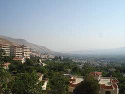
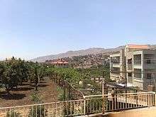
Al-Zabadani or Az-Zabadani (Arabic: الزبداني) is a city and popular hill station in southwestern Syria in the Rif Dimashq Governorate, close to the border with Lebanon. It is located in the center of a green valley surrounded by high mountains at an elevation of around 1,100 m.
Al-Zabadani الزبداني Az-Zabadani | |
|---|---|
 Al-Zabadani | |
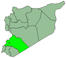
 Al-Zabadani Location in Syria | |
| Coordinates: 33°43′30″N 36°5′50″E | |
| Country | |
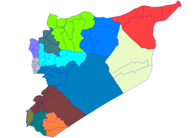
| Governorate | Rif Dimashq Governorate |
| District | al-Zabadani District |
| Nahiyah | Al-Zabadani |
| Elevation | 1,100 m (3,600 ft) |
| Population (2004 census)[1] | |
| • Total | 26,285 |
| Area code(s) | 13 |
According to the Syria Central Bureau of Statistics (CBS), in the 2004 census Al-Zabadani had a population of 26,285.[1]
Overview
%2C_Syria-LCCN2001699274.jpg)
Compared to Damascus, the weather in Al-Zabadani tends to be milder in summer, about 5–8 degrees lower, but from December to the end of February it is colder with a lot of snow, and the temperature drops to −10 degrees.
The mild summer weather, along with scenic views, led the French colonial rulers to develop the city as a traditional summer resort and hill station, and has made the town a popular resort, both for tourists and for visitors from Syrian cities on the plains, especially nearby Damascus, and for tens of thousands of visitors from the Arabian peninsula. A more elevated region than Al-Zabadani is its neighbour Bloudan, also a resort for thousands of tourists. Bloudan is about 1,500 metres above sea level.
Al-Zabadani is predominantly Sunni, with a substantial Christian population, who have their own church and monastery. Before the Syrian Civil War, Al-Zabadani was rapidly growing and was well connected to Damascus. The War led to substantial destruction and damage of infrastructure and property, with rebuilding in progress.
Climate
Al-Zabadani has a hot-summer Mediterranean climate (Köppen climate classification: Csa). In winter there is more rainfall than in summer. The average annual temperature in Al-Zabadani is 14.1 °C (57.4 °F). About 510 mm (20.08 in) of precipitation falls annually.
| Climate data for Al-Zabadani | |||||||||||||
|---|---|---|---|---|---|---|---|---|---|---|---|---|---|
| Month | Jan | Feb | Mar | Apr | May | Jun | Jul | Aug | Sep | Oct | Nov | Dec | Year |
| Average high °C (°F) | 9.1 (48.4) |
10.1 (50.2) |
13.7 (56.7) |
18.3 (64.9) |
23.7 (74.7) |
28.4 (83.1) |
31.3 (88.3) |
31.8 (89.2) |
28.9 (84.0) |
23.7 (74.7) |
16.7 (62.1) |
10.8 (51.4) |
20.5 (69.0) |
| Average low °C (°F) | 0.3 (32.5) |
0.5 (32.9) |
3.0 (37.4) |
6.3 (43.3) |
9.5 (49.1) |
13.2 (55.8) |
15.5 (59.9) |
15.7 (60.3) |
12.5 (54.5) |
8.8 (47.8) |
5.0 (41.0) |
1.4 (34.5) |
7.6 (45.8) |
| Average precipitation mm (inches) | 116 (4.6) |
101 (4.0) |
75 (3.0) |
34 (1.3) |
17 (0.7) |
0 (0) |
0 (0) |
0 (0) |
1 (0.0) |
16 (0.6) |
51 (2.0) |
99 (3.9) |
510 (20.1) |
| Source: Climate-Data.org,Climate data | |||||||||||||
Syrian Civil War
Al-Zabadani is vitally important to the Syrian government being located along the Lebanon border. It is also strategically important to Iran because, since at least as late as June 2011, it served as the Islamic Revolutionary Guard Corps's logistical hub for supplying Hezbollah.[2]
On 18 January 2012, Zabadani became the first city to fall to the Free Syrian Army (FSA), following a bloody battle that lasted 11 days.[3] The Syrian Army regained control of the city by 11 February.
By late July 2012, Zabadani had become a base of operations for Hezbollah and the Iranian Guards.[4] In August, local fighters retook 70% of Zabadani with only a few isolated army checkpoints remaining.[5] On 28 February 2014, a truce was reached between government and the rebels.[6] Later it was reported that the truce broke down and that rebels attacked government checkpoints, with the government besieging and shelling the town.[7] On 26 April 2014, the rebels surrendered after intense fighting with government troops, losing their last stronghold along Lebanon's border,[8] only to regain control of the city months later. Following an extended siege by the Syrian Army and Hezbollah, a U.N.-brokered agreement was finally signed in September 2015, under which the city was successively evacuated by the rebels and control ceded back to the Syrian government on 19 April 2017.[9]
City twinning
References
- General Census of Population and Housing 2004 Archived 2013-01-13 at Archive.today. Syria Central Bureau of Statistics (CBS). Rif Dimashq Governorate. (in Arabic)
- Holliday, Joseph (March 2012), Syria's Armed Opposition (PDF), Middle East Security Report 3, Institute for the Study of War, p. 25, archived from the original (PDF) on 12 May 2012, retrieved 9 July 2012
- Fahim, Kareem (January 21, 2012). "In Syrian city, a calm that few expect to last". The New York Times. Retrieved 2012-01-22.
- "Iran's Hizbullah sends more troops to help Assad storm Aleppo, fight Sunnis". World Tribune. Nicosia. 29 July 2012. Retrieved 27 November 2012.
- "On the ground in Zabadani, a Syrian town in revolt". The Nation. 2012-08-13. Retrieved 2013-08-29.
- "هدوء حذر تشهده الزبداني وأنباء عن هدنة بين الحر وقوات النظام" [Cautious calm witnessed in Zabadani and news of a truce between the Free Syrian Army and the government forces].
- Blanford, Nicholas. "Town by town, Assad regime retakes southwestern Syria". The Christian Science Monitor. Yahoo!. Archived from the original on 9 April 2014. Retrieved 8 April 2014.
- "Syria rebels surrender in border town". Al Jazeera. Retrieved 25 October 2014.
- "ZABADANI: THE LAST REBELS LEAVE". Euronews. 19 April 2017.
- "اتفاق توءمة بين مدينة نوين كيرشين الألمانية والزبداني Twinning agreement between the city of Nguyen Kirchen German and Zabadani". The New Alphabet/SANA. Retrieved 2009-11-30.