Yaxcabá Municipality
Yaxcabá Municipality (In the Yucatec Maya Language: “place of green earth”) is one of the 106 municipalities in the Mexican state of Yucatán containing (1079 km2) of land and located roughly 80 km northeast of the city of Mérida.[1]
Yaxcabá | |
|---|---|
Municipality | |
 Municipal Palace | |
 Seal | |
 | |
Yaxcabá Location of the Municipality in Mexico | |
| Coordinates: 20°04′N 89°02′W | |
| Country | |
| State | |
| Mexico Ind. | 1821 |
| Yucatan Est. | 1824 |
| Municipality Est. | 1923[1] |
| Government | |
| • Type | |
| • Municipal President | Melba Rosana Gamboa Avila[1] |
| Area | |
| • Total | 1,079 km2 (417 sq mi) |
| [1] | |
| Elevation | 27 m (89 ft) |
| Population (2010[3]) | |
| • Total | 14,802 |
| Time zone | UTC-6 (Central Standard Time) |
| • Summer (DST) | UTC-5 (Central Daylight Time) |
| INEGI Code | 104 |
| Major Airport | Merida (Manuel Crescencio Rejón) International Airport |
| IATA Code | MID |
| ICAO Code | MMMD |

History
The town is believed to have been founded by the Cocom who survived the destruction of Mayapan, in 1441. After the conquest the area became part of the encomienda system.[1] The encomienda was established in 1549 for Martín de Luguízamo[4] and was assigned in 1562 to Joaquín de Luguízamo.[1] Juan Jiménez de Tejeda took over the encomienda in 1607 and in 1622, Gregorio de Cetina became encomendero, leaving the property in 1688 to Diego de Cetina. In 1693 the trust was the responsibility of Cristóbal Maldonado Jurado and a minor Fernando Maldonado.[4] Andrés de Valdés later served as encomendero.[1]
Yucatán declared its independence from the Spanish Crown in 1821. On 8 September 1848, a group of Indians under the leadership of Cecilio Chí captured the town during the Caste War of Yucatán. Coronel Eulogio Rosado who was stationed in Mérida retook the village on the orders of the government.[1]
In 1923, Yaxcabá was designated as its own municipality.[1]
Governance
The municipal president is elected for a three-year term. The town council has nine councilpersons, who serve as Secretary and councilors of education, security and roads, agriculture and policing, public lighting, legalities, cemeteries, health, and sports.[5]
Communities
The head of the municipality is Yaxcabá, Yucatán. There are 66 different communities in the municipality, including Abán, Acapulco, Balam, Canakon, Cenote, Chanciteen, Chich, Chimay, Cholul, Chunchucmil, Cola Blanca, Huchin, Kankabzonot, Libre Unión, Miguel Hidalgo, Nicteil, Oxulá, Paraíso, Popola, Quintana Roo, Sacnité, Sahcabá, San Arturo, San Francisco, San Isidro, San José, San José I, San Juan de los Itzá, San Manuel, San Marcos, San Pedro, San Tomás, Santa Amelia, Santa Eugenia, Santa María, Santa Rita, Santa Rosa, Santo Domingo, Sipché, Tahdzibichén, Teelhú, Tiholop, Tinucáh, Tixcacaltuyub, Tzupich, Tzutzuyub, Xabitita, Xanlá, Xíat, Xinchil, Xlapák, X-ochil, Xolobitancia, X-tosil, Xuul, Yokdzonot, Yoxunah. The significant populations are shown below:[1]
| Community | Population |
|---|---|
| Entire Municipality (2010) | 14,802[3] |
| Canakom | 412 in 2005[6] |
| Kancabdzonot | 931 in 2005[7] |
| Libre Unión | 1739 in 2005[8] |
| Santa María | 225 in 2005[9] |
| Tahdzibichen | 1567 in 2005[10] |
| Tiholop | 1333 in 2005[11] |
| Tixcacaltuyub | 1899 in 2005[12] |
| Yaxcabá | 2799 in 2005[13] |
| Yaxunah | 590 in 2005[14] |
| Yokdzonot | 816 in 2005[15] |
Local Festivals
Each year in April is a fiesta held for the Holy Cross. From 20 to 29 June the town hosts a celebration in honor St. Peter and St. Paul and from 1 to 5 October there is a festival in honor of St. Francis of Assisi.[1]
Landmarks
Architectural
- Church of St. Francis of Assisi from the colonial era
- Chapel of the Virgin of Guadalupe from the colonial era.
- Church of Santa Cruz
- Former convent and Church of St. Peter
- Chapel of St. Nicholas
Archaeological
- Libre unión Yaxunáh, Ixpanioh, Xucul, Yokdzonot, Xcanyá, Tixcacaltuyub and Yanláh.
References
- "Municipios de Yucatán »Yaxcabá" (in Spanish). Retrieved 4 July 2015.
- "Priistas agradecidos" (in Spanish). Mérida, Mexico: Diario de Yucarán. 12 July 2012. Retrieved 4 July 2015.
- "Mexico In Figures:Yaxcabá, Yucatán". INEGI (in Spanish and English). Aguascalientes, México: Instituto Nacional de Estadística y Geografía (INEGI). Retrieved 5 July 2015.
- García Bernal, Manuela Cristina (1978). Población y encomienda en Yucatán bajo los Austrias (in Spanish). Sevilla: Escuela de Estudios Hispano-Americanos. p. 529. ISBN 978-8-400-04399-5. Retrieved 3 July 2015.
- "Yaxcabá". inafed (in Spanish). Mérida, Mexico: Enciclopedia de Los Municipios y Delegaciones de México. Retrieved 4 July 2015.
- "Canakom". PueblosAmerica (in Spanish). PueblosAmerica. 2005. Retrieved 5 July 2015.
- "Kancabdzonot". PueblosAmerica (in Spanish). PueblosAmerica. 2005. Retrieved 5 July 2015.
- "Libre Unión". PueblosAmerica (in Spanish). PueblosAmerica. 2005. Retrieved 5 July 2015.
- "Santa María". PueblosAmerica (in Spanish). PueblosAmerica. 2005. Retrieved 5 July 2015.
- "Tahdzibichen". PueblosAmerica (in Spanish). PueblosAmerica. 2005. Retrieved 5 July 2015.
- "Tiholop". PueblosAmerica (in Spanish). PueblosAmerica. 2005. Retrieved 5 July 2015.
- "Tixcacaltuyub". PueblosAmerica (in Spanish). PueblosAmerica. 2005. Retrieved 5 July 2015.
- "Yaxcabá". PueblosAmerica (in Spanish). PueblosAmerica. 2005. Retrieved 5 July 2015.
- "Yaxunah". PueblosAmerica (in Spanish). PueblosAmerica. 2005. Retrieved 5 July 2015.
- "Yokdzonot". PueblosAmerica (in Spanish). PueblosAmerica. 2005. Retrieved 5 July 2015.
Mérida (capital) | |||||||||||||||
| Topics | 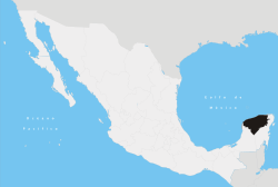 | ||||||||||||||
| Metros | |||||||||||||||
| Larger cities | |||||||||||||||
| Smaller cities |
| ||||||||||||||
| Municipalities |
| ||||||||||||||