Progreso, Yucatán
Progreso (Spanish pronunciation: [pɾoˈɣɾeso]) is a port city in the Mexican state of Yucatán, located on the Gulf of Mexico in the north-west of the state some 30 minutes north of state capital Mérida (the biggest city on the Yucatán Peninsula) by highway. As of the Mexican census of 2010, Progreso had an official population of 37,369 inhabitants, the sixth largest community in the state in population. The city is also the municipal seat of the surrounding municipality of the same name. The municipality's area is 270.10 km2 (104.29 sq mi) and its population at the census was 49,454 inhabitants. It includes Scorpion Reef with its five islets 130 km offshore (north) on the outer edge of Campeche Bank.[1] Its largest other towns are Chicxulub, Campestre Flamboyanes, and Chelem.
Progreso | |
|---|---|
City | |
 Progreso Beach | |
 Coat of arms | |
 Location of Progreso in Yucatán | |
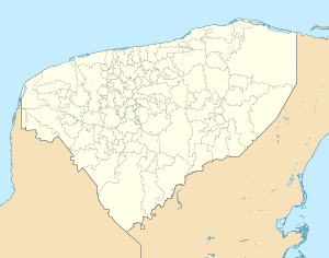 Progreso Location of Progreso in Yucatán Progreso Progreso (Mexico) | |
| Coordinates: 21°16′48″N 89°40′12″W | |
| Government | |
| • Municipal President | Julián Zacarías Curi (2018-2021) |
| Area | |
| • Total | 270.10 km2 (104.29 sq mi) |
| Elevation | 0 m (0 ft) |
| Population | |
| • Total | 53,958 |
| • Density | 200/km2 (520/sq mi) |
| Time zone | UTC-6 (CST) |
| • Summer (DST) | UTC-5 (CDT) |
| Codigo Postal | 97320 |
| Area code(s) | 969 |
| Major Airport | Merida (Manuel Crescencio Rejón) International Airport |
| IATA Code | MID |
| ICAO Code | MMMD |
Progreso is a center for both the fishing industry and the container industry. All containers arrive in Progreso and are distributed to Yucatán, Campeche and Quintana Roo.
Progreso also is one of the newest ports for large cruise ships and an emerging balneario resort destination. Passengers disembark on a very long pier, the Terminal Remota opened in 1989[2] that juts out 6.5 km (4.0 mi) into the Gulf of Mexico. Passengers are taken to shore to visit Progreso, Mérida or the Maya civilization archaeological sites of Uxmal and Dzibilchaltun.
During the months of July and August the beaches fill with thousands of mostly local tourists, as it is traditional in these months for residents of Mérida to leave the city and spend the summer in the cooler seaside environment.
History
Progreso was founded in 1872, to create a sea port closer to Mérida than the older port of Sisal, Yucatán. [3]
Climate
Despite its coastal location and fairly humid climate (average humidity around 70–80%), Progreso has a semi-arid climate (Köppen climate classification BSh).[4] There is little variation in average temperatures though the winter months from December to March are noticeably more cool. Precipitation is scarce throughout the year but is more abundant from June to October. On average, there are 36 days with measureable rainfall.
| Climate data for Progreso, Yucatan (1951–1980) | |||||||||||||
|---|---|---|---|---|---|---|---|---|---|---|---|---|---|
| Month | Jan | Feb | Mar | Apr | May | Jun | Jul | Aug | Sep | Oct | Nov | Dec | Year |
| Record high °C (°F) | 33.5 (92.3) |
34.4 (93.9) |
38.6 (101.5) |
38.0 (100.4) |
39.2 (102.6) |
35.0 (95.0) |
34.6 (94.3) |
33.5 (92.3) |
33.6 (92.5) |
33.0 (91.4) |
33.6 (92.5) |
33.0 (91.4) |
39.2 (102.6) |
| Average high °C (°F) | 25.5 (77.9) |
26.2 (79.2) |
28.6 (83.5) |
29.9 (85.8) |
30.2 (86.4) |
30.0 (86.0) |
29.5 (85.1) |
29.6 (85.3) |
29.6 (85.3) |
28.4 (83.1) |
27.1 (80.8) |
25.8 (78.4) |
28.4 (83.1) |
| Daily mean °C (°F) | 22.9 (73.2) |
23.1 (73.6) |
24.9 (76.8) |
26.2 (79.2) |
27.1 (80.8) |
27.3 (81.1) |
27.2 (81.0) |
27.3 (81.1) |
27.2 (81.0) |
26.5 (79.7) |
24.9 (76.8) |
23.5 (74.3) |
25.7 (78.3) |
| Average low °C (°F) | 20.1 (68.2) |
20.0 (68.0) |
21.6 (70.9) |
22.9 (73.2) |
24.1 (75.4) |
24.7 (76.5) |
24.6 (76.3) |
24.8 (76.6) |
24.8 (76.6) |
24.2 (75.6) |
22.5 (72.5) |
20.9 (69.6) |
22.9 (73.2) |
| Record low °C (°F) | 10.0 (50.0) |
9.2 (48.6) |
13.8 (56.8) |
14.8 (58.6) |
17.6 (63.7) |
19.2 (66.6) |
18.8 (65.8) |
19.6 (67.3) |
19.8 (67.6) |
17.6 (63.7) |
15.0 (59.0) |
14.0 (57.2) |
9.2 (48.6) |
| Average rainfall mm (inches) | 15.4 (0.61) |
19.5 (0.77) |
3.5 (0.14) |
6.9 (0.27) |
25.3 (1.00) |
64.6 (2.54) |
44.5 (1.75) |
48.5 (1.91) |
93.6 (3.69) |
64.2 (2.53) |
20.1 (0.79) |
17.1 (0.67) |
423.2 (16.66) |
| Average rainy days (≥ 0.1 mm) | 1.60 | 1.70 | 0.66 | 0.80 | 1.96 | 4.60 | 4.30 | 4.26 | 6.96 | 4.30 | 2.46 | 2.51 | 36.11 |
| Average relative humidity (%) | 75 | 73 | 72 | 72 | 75 | 79 | 81 | 81 | 82 | 76 | 75 | 76 | 76 |
| Mean monthly sunshine hours | 199.6 | 193.0 | 203.4 | 188.7 | 221.1 | 218.7 | 234.8 | 233.3 | 200.4 | 207.8 | 194.0 | 198.0 | 2,492.8 |
| Source: Colegio de Postgraduados (humidity and sun)[5] | |||||||||||||
Photo gallery
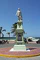 Progreso, Yucatán founder's statue
 Lighthouse at Progreso
 Beach at Progreso
 Progreso's International Boulevard (locally named as Malecón) at night.
References
- "Instituto Nacional de Ecología" (in Spanish). Parque Marino Nacional Arrecife Alacranes. Retrieved 13 April 2010.
- "XVII Aniversario de la Terminal Remota de Puerto Progreso" (in Portuguese). Administracion Portuaria Integral de Progreso S.A. de C.V. 6 October 2006. Retrieved 9 August 2012.
- Peel, M. C. and Finlayson, B. L. and McMahon, T. A. (2007). "Updated world map of the Köppen–Geiger climate classification" (PDF). Hydrol. Earth Syst. Sci. 11: 1633–1644. doi:10.5194/hess-11-1633-2007. ISSN 1027-5606.CS1 maint: multiple names: authors list (link)
- "Normales climatológicas para Progreso, Yuc" (in Spanish). Colegio de Postgraduados. Archived from the original on 13 April 2013. Retrieved 25 February 2013.
- Link to tables of population data from Census of 2010 INEGI: Instituto Nacional de Estadística, Geografía e Informática
- Yucatán Enciclopedia de los Municipios de México
External links
| Wikimedia Commons has media related to Progreso, Yucatán. |
| Wikivoyage has a travel guide for Progreso. |
- Yucatán Enciclopedia de los Municipios de México
Mérida (capital) | |||||||||||||||
| Topics |  | ||||||||||||||
| Metros | |||||||||||||||
| Larger cities | |||||||||||||||
| Smaller cities |
| ||||||||||||||
| Municipalities |
| ||||||||||||||