Calotmul Municipality
Calotmul Municipality (Yucatec Maya: "place of two conjoined hills") is one of the 106 municipalities in the Mexican state of Yucatán containing (361.50 km2) of land and is located roughly 185 kilometres (115 mi) east of the city of Mérida.[2]
Calotmul | |
|---|---|
Municipality | |
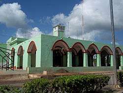 Municipal Offices of Calotmul, Yucatán | |
 Region 5 Noreste #008 | |
Calotmul Location of the Municipality in Mexico | |
| Coordinates: 21°01′08″N 88°10′37″W | |
| Country | |
| State | |
| Mexico Ind. | 1821 |
| Yucatán Est. | 1824 |
| Government | |
| • Type | |
| • Municipal President | Manuel Jesús Polanco Contreras[2] |
| Area | |
| • Total | 361.50 km2 (139.58 sq mi) |
| [2] | |
| Elevation | 23 m (75 ft) |
| Population (2010[3]) | |
| • Total | 4,095 |
| • Density | 11/km2 (29/sq mi) |
| • Demonym | Umanense |
| Time zone | UTC-6 (Central Standard Time) |
| • Summer (DST) | UTC-5 (Central Daylight Time) |
| INEGI Code | 008 |
| Major Airport | Merida (Manuel Crescencio Rejón) International Airport |
| IATA Code | MID |
| ICAO Code | MMMD |
| Municipalities of Yucatán | |
History
There is no accurate data on when the town was founded, but during the conquest, it became part of the encomienda system[2] and the first encomendero was Rodrigo Alvarez in 1549.[4] Subsequent encomenderos included Nicolas del Puerto (1665), who was entrusted with 400 indigenous persons; Antonio de la Felguera Castillo (1710), who had charge over 584 natives; and Marco Ayala.[2]
Yucatán declared its independence from the Spanish Crown in 1821, and in 1825 the area was assigned to the Tizimín Municipality.[2] In 1988 it was confirmed as head of its own municipality.[5]
Governance
The municipal president is elected for a three-year term. The town council has four councilpersons, who serve as Secretary and councilors of markets, parks and gardens, and cemeteries.[6]
Communities
The head of the municipality is Calotmul, Yucatán. There are 17 populated areas of the municipality[6] which include Pocobóch, Táhcabo and Yokdzonot Meneses. The significant populations are shown below:[2]
| Community | Population |
|---|---|
| Entire Municipality (2010) | 4,095[3] |
| Calotmul | 2623 in 2005[7] |
| Pocobóch | 774 in 2005[8] |
| Táhcabo | 412 in 2005[9] |
Local festivals
Every year from 1 to 8 December the town celebrates a festival in honor of the Immaculate Conception.[2]
Tourist attractions
- Church of Immaculate Conception, built in the seventeenth century
- Cenote Actun-Dzonot
- Cenote Azúl
- Cenote Baal-Kax
- Cenote Bal-Che
- Cenote Chacal Has
- Cenote Chakah
References
- "Alcaldes" (in Spanish). Mérida, Mexico: Buenas Tareas. 23 February 2013. Retrieved 7 August 2015.
- "Municipios de Yucatán »Calotmul" (in Spanish). Retrieved 7 August 2015.
- "Mexico In Figures:Calotmul, Yucatán". INEGI (in Spanish and English). Aguascalientes, México: Instituto Nacional de Estadística y Geografía (INEGI). Archived from the original on 6 May 2015. Retrieved 3 August 2015.
- García Bernal, Manuela Cristina (1978). Población y encomienda en Yucatán bajo los Austrias (in Spanish). Sevilla: Escuela de Estudios Hispano-Americanos. p. 503. ISBN 978-84-00-04399-5. Retrieved 1 August 2015.
- "Estado de Yucatán. División Territorial de 1810 a 1995" (PDF). inegi (in Spanish). Aguascalientes, Mexico: Instituto Nacional de Estadística, Geografía e Informática. 1996. p. 123. Retrieved 7 August 2015.
- "Calotmul". inafed (in Spanish). Mérida, Mexico: Enciclopedia de Los Municipios y Delegaciones de México. Retrieved 7 August 2015.
- "Calotmul" (in Spanish). PueblosAmerica. 2005. Retrieved 7 August 2015.
- "Pocobóch" (in Spanish). PueblosAmerica. 2005. Retrieved 7 August 2015.
- "Táhcabo" (in Spanish). PueblosAmerica. 2005. Retrieved 6 August 2015.
Mérida (capital) | |||||||||||||||
| Topics | 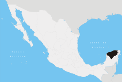 | ||||||||||||||
| Metros | |||||||||||||||
| Larger cities | |||||||||||||||
| Smaller cities |
| ||||||||||||||
| Municipalities |
| ||||||||||||||