Xiling District
Xiling (Chinese: 西陵区; pinyin: Xīlíng) is a district of Yichang, Hubei, People's Republic of China. It includes the central part of Yichang's urban area, on the left (northwestern) bank of the Yangtze River.
Xiling 西陵区 | |
|---|---|
District | |
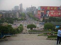 Looking down one of Yichang's main streets | |
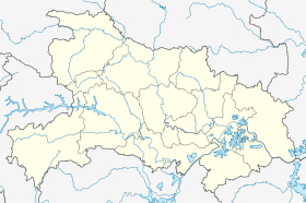 Xiling Location in Hubei | |
| Coordinates: 30°42′18″N 111°17′23″E | |
| Country | People's Republic of China |
| Province | Hubei |
| Prefecture-level city | Yichang |
| Township-level divisions |
further divided into:
|
| Established | December 13, 1986 |
| District seat | Xiling Subdistrict (西陵街道) |
| Area | |
| • Total | 89.9 km2 (34.7 sq mi) |
| Population (2010)[2] | |
| • Total | 512,074 |
| • Density | 5,700/km2 (15,000/sq mi) |
| Time zone | UTC+8 (China Standard) |
| Website | www |
History
In September 1949, the main part of the territory of modern-day Xiling was included in City Government Districts Two and Three (市人民政府第二、三區政府). Kangzhuang Road (康莊路), Fusui Road (福綏路) and Huaiyuan Road (懷遠路) were part of District One (第一區政府).[3] In August 1950, these districts were eliminated and the city was governed by the police offices and resident committees.[1]
In August 1952, the territory of modern-day Xiling District was divided amongst Yichang City People's Government's Second, Third, Fourth and Fifth Subdistrict Government Committees (“宜昌市人民政府第二、三、四、五街政委員會”). In March 1953, these committees were renamed as City Government Organ Subdistrict Offices (市政府的派出機關街道辦事處). In April 1956, these areas were named Binjianglu ("Riverfront Road") Subdistrict Office (濱江路街道辦事處), Jiefanglu ("Liberation Road") Subdistrict Office (解放路街道辦事處), Xueyuanjie ("School Street") Subdistrict Office (學院街街道辦事處), and Guloujie ("Drum Tower Street") Subdistrict Office (鼓樓街街道辦事處) respectively.[1]
In May 1960, the Yichang government decided to make the five then-existing subdistricts (街道辦事處) into three people's communes (人民公社). Binjianglu Subdistrict Office, Jiefanglu Subdistrict Office and Xueyuanjie Subdistrict Office were united into Jiefang ("Liberation") People's Commune (解放人民公社). Guloujie Subdistrict Office became Xiling People's Commune (西陵人民公社). Jiefang People's Commune consisted of five subcommunes (分社): Hepingli (和平里), Jiefanglu ("Liberation Road") (解放路), Xueyuanjie ("School Street") (學院街), Shiweijiguan (市委機關), and Yunjilu (雲集路). Xiling People's Commune consisted of four subcommunes: Minzhu ("Democracy") (民主), Xiling (西陵), Sanxia ("Three Gorges") (三峽) and Xiba (西坝).[1]
In 1967, Xiling People's Commune was renamed as Yichang City Dongfanghong ("The East is Red") People's Commune (宜昌市东方红人民公社).[1]
In May 1968, the Yichang Area Revolutionary Committee (宜昌地区革命委员会) approved the creation of Yichang City Jiefang Commune Committee (宜昌市解放公社革命委员会) and Yichang City Dongfanghong Commune Committee (宜昌市东方红公社革命委员会).[1]
In August 1980, the Yichang City Revolutionary Committee (宜昌市革命委员会) made Yichang City Dongfanghong People's Commune into Xiling Subdistrict and Yichang City Jiefang Renmin People's Commune into Yunji Subdistrict. Gezhouba Subdistrict and Yemingzhu Subdistrict came under the joint administration of Yichang and the Gezhouba Engineering Office (葛洲坝工程局).[1]
In an act of the State Council of the People's Republic of China (国函〔1986〕188号: 关于宜昌市成立三个市辖区的请示) and the government of Hubei province (湖北省民政厅) (关于宜昌市设立三个市辖区调整方案的意见) taken on December 13, 1986 and carried out in the following year, Xiling District, Wujiagang District and Dianjun District were officially established as districts.[1][2]
On April 3, 1987, Xiling District Preliminary Group (西陵区筹备组 was created. On June 2, 1987, the district's National People's Congress, Government, and Chinese People's Political Consultative Conference Preparation Groups (人大、政府、政协筹备小组) were created. On June 3, 1987, the Yichang City Xiling District Community Party Committee (中共宜昌市西陵区委员会 was created. On November 18, 1987, Xiling District held its first National People's Congress meeting (西陵区第一届人民代表大会第一次会议) and selected the first government for Xiling District.[1]
As of 1996, Xiling District had an area of 89.8 km2, a population of 344,000 and was made up of seven subdistricts, one township and one economic development zone including the now-disbanded Gulou Subdistrict (鼓楼街道).[2]
As of the Fifth National Population Census of the People's Republic of China in 2000, Xiling District had a population of 427,299 and was made up of seven subdistricts, one township, one economic development zone and one scenic area.[2]
As of the end of 2004, Xiling District was made up of six subdistricts (not including Gulou Subdistrict) and one township which were further divided into eighty-two residential communities and eleven villages.[2]
As of the Sixth National Population Census of the People's Republic of China in 2010, Xiling District had a population of 512,074 and was made up of six subdistricts, one township, one economic development zone and one scenic area.[2]
Administrative divisions
The district administers 9 subdistricts and 1 township:[1][2][4][5]
Subdistricts:
- Xiling Subdistrict (西陵街道), Xueyuan Subdistrict (学院街道), Yunji Subdistrict (云集街道), Xiba Subdistrict (西坝街道), Gezhouba Subdistrict (葛洲坝街道), Yemingzhu Subdistrict (夜明珠街道), Dongyuan Subdistrict (东苑街道), Nanyuan Subdistrict (南苑街道), Beiyuan Subdistrict (北苑街道)
The only township is Yaowan Township (窑湾乡)
Other area:
References
- 西陵区简介 [Xiling District Overview] (in Chinese). Xiling District People's Government. 17 November 2017. Retrieved 27 October 2018.
总面积89.9平方公里,常住人口54万。辖学院、云集、西陵、西坝、葛洲坝、夜明珠、窑湾等7个街道以及西陵经济开发区和解放路步行街。{...}1986年12月13日,国务院以国函〔1986〕188号文批复湖北省人民政府《关于宜昌市成立三个市辖区的请示》和湖北省民政厅《关于宜昌市设立三个市辖区调整方案的意见》,同意宜昌市设立西陵、伍家岗、点军3个市辖行政区。
(The basis for information that is not included in the quotation can be found at the webpage.) - 西陵区历史沿革 [Xiling District Historical Development] (in Chinese). XZQH.org. 14 July 2014. Retrieved 27 October 2018.
1987年设西陵区。【1986年12月13日,国务院(国函[1996][sic]188号)批准同意设立宜昌市西陵区、伍家岗区、点军区。】{...}1996年,西陵区面积89.8平方千米,{...}2010年第六次人口普查,西陵区常住总人口512074人,{...}全区现辖9个街道、1个乡:西陵街道、学院街道、云集街道、西坝街道、葛洲坝街道、夜明珠街道、东苑街道、南苑街道、北苑街道、窑湾乡。
- 宜昌市志 [Yichang City Annals].
1949年9月宜昌市各区基本情况表 (from the September 1949 Yichang District Basic Information List)
- 2011年统计用区划代码和城乡划分代码:西陵区 (in Chinese). National Bureau of Statistics of the People's Republic of China. December 2017. Retrieved 2013-01-02.
- 2017年统计用区划代码和城乡划分代码:西陵区 [2017 Statistical Area Numbers and Rural-Urban Area Numbers: Xiling District]. National Bureau of Statistics of the People's Republic of China. 2017. Retrieved 27 October 2018.
统计用区划代码 名称 420502001000 西陵街道 420502002000 学院街道 420502003000 云集街道 420502004000 西坝街道 420502005000 葛洲坝街道 420502006000 夜明珠街道 420502007000 东苑街道办事处 420502008000 南苑街道办事处 420502009000 北苑街道办事处 420502201000 窑湾乡 420502401000 峡口风景区