Wakkanai, Hokkaido
Wakkanai (稚内市, Wakkanai-shi, Ainu: ヤㇺワッカナイ Yam-wakka-nay meaning "cold water river"),[1] (Russian: Вакканай) is a city located in Sōya Subprefecture, Hokkaido, Japan. It is the capital of Sōya Subprefecture, and the northernmost city in Japan. It contains Japan's northernmost point, Cape Sōya, from which the Russian island of Sakhalin can be seen.
Wakkanai 稚内市 Вакканай | |
|---|---|
City | |
| Вакканай | |
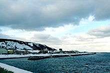
 View of Wakkanai from Wakkanai Park | |
 Flag  Seal | |
 Location of Wakkanai in Hokkaido Prefecture, highlighted in pink | |
 Wakkanai | |
| Coordinates: 45°24′56.4″N 141°40′23″E | |
| Country | Japan |
| Region | Hokkaido |
| Prefecture | Hokkaido |
| Government | |
| • Mayor | Hiroshi Kudo (since May 2011) |
| Area | |
| • Total | 761.47 km2 (294.01 sq mi) |
| Population (June 1, 2019) | |
| • Total | 33,869 |
| • Density | 44/km2 (120/sq mi) |
| Time zone | UTC+9 (Japan Standard Time) |
| - Tree | Sakura, rowan |
| - Flower | Rosa rugosa |
| Phone number | 0162-23-6161 |
| Address | 3-13-15 Chūō, Wakkanai-shi, Hokkaido 097-8686 |
| Website | www |
As of 1 June 2019, the city has an estimated population of 33,869 and a population density of 44.5 persons per km² (126 persons per mi²). The total area is 761.47 km2 (294.01 sq mi).[2][3]
History
Wakkanai was originally home to an Ainu population. The first Japanese settlement was established in 1685.[4]
- 1879: The village of Wakkanai was founded.
- 1897: Sōya Subprefecture established.
- 1901: Wakkanai village became Wakkanai town.
- 1949: Wakkanai town became Wakkanai city.
- 1955: Soya village was merged into Wakkanai city.
- 1959: Wakkanai Airport opened.
During World War II: The Imperial Japanese Navy used the harbor and port as a submarine base. Wakkanai was far enough north to be outside the range of American heavy bombers and was safe from air attack. Until the early to mid-1960s, the northern portion of the harbor remained divided by concrete sub-mooring pens. The large breakwater structure (which still exists) was actually a sub-repair facility. At the shore end there was a huge winching mechanism capable of hauling subs up into the partially enclosed structure where they could be repaired while completely out of the water. Built into the hills above the city there were several reinforced concrete bunker-type caves where (anecdotally) they were used either to store ammunition and armament, or as air raid shelters for the civilian populace. History would suggest the former use, rather than the latter. During a re-build/renovation of the harbor sometime during the 1960s or 1970s, the harbor was cleared of the concrete pens and the machinery was removed from the breakwater structure which was reconfigured.
Geography
Japan's northernmost point, Cape Sōya is located in Wakkanai, which is on a peninsula jutting towards Sakhalin Island in Russia, which it is 43 kilometres (27 miles) away from; on a clear day, the Russian island can be easily seen. There is also Benten-jima located northwest of Cape Sōya.
- Rivers: Koetoi River
- Lakes: Ōnuma Lake
Climate
Wakkanai has a humid continental climate (Köppen: Dfb) typical of Hokkaido but with strong influence of the ocean as island portions near the great land masses (such as the smaller islands of Nova Scotia),[5] with cold winters, warm summers and generally heavy precipitation from the Aleutian Low, whose winds hit the city direct from the Sea of Japan but with strong oceanic influence (46 °C). The winter is cold enough not to fall in a "Cfb" climate and the summers although very mild for typical climate "b" is warm enough to fall into a "Dfc", both in the classification of Koppen.[6] The mean annual temperature, at 6.8 °C (44.2 °F), is the second lowest for a significant population centre in Japan after Nemuro. Snowfall at 6.6 metres (260 in), the third highest for a big city in Japan after Asahikawa and Aomori and one of the highest anywhere in the world. For comparison, Nain in Canada receives 194 inches (4.9 m) of snow.
The Aleutian Low also makes the sunshine hours the lowest of Japan's major population centres and in the winter the wind speeds are the highest in Japan with an average of 20.2 km/h (12.6 mph), which adds to the −4.7 °C (23.5 °F) cold of a typical winter day. The city's port is usually usable throughout the year, but does occasionally freeze in cold winters.
| Climate data for Wakkanai (1981–2010) | |||||||||||||
|---|---|---|---|---|---|---|---|---|---|---|---|---|---|
| Month | Jan | Feb | Mar | Apr | May | Jun | Jul | Aug | Sep | Oct | Nov | Dec | Year |
| Record high °C (°F) | 7.4 (45.3) |
9.3 (48.7) |
13.1 (55.6) |
20.2 (68.4) |
26.9 (80.4) |
26.8 (80.2) |
29.9 (85.8) |
31.3 (88.3) |
29.7 (85.5) |
23.5 (74.3) |
17.4 (63.3) |
11.5 (52.7) |
31.3 (88.3) |
| Mean maximum °C (°F) | 3.1 (37.6) |
2.6 (36.7) |
6.8 (44.2) |
14.2 (57.6) |
19.7 (67.5) |
22.1 (71.8) |
25.5 (77.9) |
26.9 (80.4) |
24.0 (75.2) |
19.0 (66.2) |
13.2 (55.8) |
7.0 (44.6) |
27.3 (81.1) |
| Average high °C (°F) | −2.7 (27.1) |
−2.5 (27.5) |
1.2 (34.2) |
7.2 (45.0) |
12.0 (53.6) |
15.7 (60.3) |
19.7 (67.5) |
22.3 (72.1) |
19.7 (67.5) |
13.7 (56.7) |
6.1 (43.0) |
0.1 (32.2) |
9.4 (48.9) |
| Daily mean °C (°F) | −4.7 (23.5) |
−4.7 (23.5) |
−1.0 (30.2) |
4.4 (39.9) |
8.8 (47.8) |
12.7 (54.9) |
16.8 (62.2) |
19.6 (67.3) |
16.8 (62.2) |
11.1 (52.0) |
3.6 (38.5) |
−2.0 (28.4) |
6.8 (44.2) |
| Average low °C (°F) | −6.8 (19.8) |
−7.1 (19.2) |
−3.5 (25.7) |
1.8 (35.2) |
6.0 (42.8) |
10.1 (50.2) |
14.5 (58.1) |
17.3 (63.1) |
14.0 (57.2) |
8.1 (46.6) |
1.0 (33.8) |
−4.2 (24.4) |
4.3 (39.7) |
| Mean minimum °C (°F) | −12.7 (9.1) |
−12.7 (9.1) |
−9.5 (14.9) |
−2.7 (27.1) |
1.2 (34.2) |
5.5 (41.9) |
9.8 (49.6) |
13.2 (55.8) |
8.9 (48.0) |
1.8 (35.2) |
−6.2 (20.8) |
−9.6 (14.7) |
−13.9 (7.0) |
| Record low °C (°F) | −19.4 (−2.9) |
−18.3 (−0.9) |
−17.4 (0.7) |
−8.0 (17.6) |
−2.2 (28.0) |
2.1 (35.8) |
6.4 (43.5) |
8.9 (48.0) |
3.5 (38.3) |
−4.4 (24.1) |
−11.4 (11.5) |
−16.0 (3.2) |
−19.4 (−2.9) |
| Average precipitation mm (inches) | 84.3 (3.32) |
60.7 (2.39) |
50.3 (1.98) |
49.0 (1.93) |
67.6 (2.66) |
53.0 (2.09) |
90.6 (3.57) |
116.0 (4.57) |
123.5 (4.86) |
134.1 (5.28) |
120.9 (4.76) |
112.8 (4.44) |
1,062.7 (41.84) |
| Average snowfall cm (inches) | 173 (68) |
143 (56) |
102 (40) |
21 (8.3) |
0 (0) |
0 (0) |
0 (0) |
0 (0) |
0 (0) |
1 (0.4) |
53 (21) |
160 (63) |
656 (258) |
| Average precipitation days (≥ 1.0 mm) | 20.3 | 16.1 | 11.7 | 8.4 | 8.6 | 7.4 | 7.9 | 8.6 | 10.8 | 14.0 | 17.0 | 20.8 | 151.7 |
| Average snowy days | 30.1 | 26.2 | 24.2 | 9.2 | 1.2 | 0.0 | 0.0 | 0.0 | 0.0 | 3.4 | 17.7 | 28.2 | 140.0 |
| Average relative humidity (%) | 72 | 72 | 71 | 75 | 79 | 85 | 86 | 84 | 75 | 68 | 67 | 70 | 75 |
| Mean monthly sunshine hours | 45.6 | 80.3 | 138.6 | 171.8 | 185.6 | 166.3 | 146.8 | 148.5 | 177.1 | 135.9 | 57.6 | 30.1 | 1,484.4 |
| Source 1: Japan Meteorological Agency | |||||||||||||
| Source 2: Climatebase.ru (records) | |||||||||||||
Transportation
Air
Wakkanai Airport is located in Wakkanai.
Rail
JR Hokkaido runs a diesel train service on the Sōya Main Line from Asahikawa to Sapporo.
- Sōya Main Line : Yūchi – Bakkai – Minami-Wakkanai – Wakkanai
Sea

Heartland Ferry operates seasonal ferry service to Rebun Island and Rishiri Island. Ferry service to Korsakov on Sakhalin Island was terminated on September 18, 2015. Wakkanai governor KUDO Hiroshi pledged to restore ferry service to Sakhalin and in 2016, the route resumed operation between the months of June and September of each year and is commercially operated by the Commonwealth of Dominica flagged vessel Penguin 33, which is a High-speed craft owned by Penguin International Limited and operated by Sakhalin Shipping Company.[7][8]
Education
University
High schools
Private
- Wakkanai Otani High School
Tourist attractions
- The Daisuke Matsuzaka Museum, dedicated to the baseball pitcher "Dice-K" and opened in 2008, is located in Wakkanai, which is his father's hometown.[9]
- Wakkanai Park, home to the Centennial Tower, commemorating the 100th anniversary of the founding of the city,[10] and the Hoppo Memorial Museum[11]
- Cape Sōya, home to a monument to the northernmost point in Japan[10]
- Hokumon Jinja, a Shinto shrine
Sister cities and friendship cities
Friendship cities
Domestic

International

Sister ports

References
- アイヌ語地名リスト [Ainu Language Place Name List] (PDF) (in Japanese). Office of Ainu Measures Promotion, Department of Environment and Lifestyle, Hokkaido Government. Retrieved January 29, 2015.
- 稚内市の概要 [Outline of Wakkanai] (in Japanese). Wakkanai, Hokkaido Prefecture, Japan: City of Wakkanai. 2013. Retrieved 2013-11-09.
- 稚内市の人口と世帯 [Population and Households of Wakkanai] (in Japanese). Wakkanai, Hokkaido Prefecture, Japan: City of Wakkanai. 2013. Retrieved 2013-11-09.
- History of Wakkanai
- Muller, M. J. (2012-12-06). Selected climatic data for a global set of standard stations for vegetation science. Springer Science & Business Media. ISBN 9789400980402.
- "Koppen Climate Classification" (PDF).
- 稚内市. "Sakhalin regular line / Wakkanai-shi". www.city.wakkanai.hokkaido.jp.e.dh.hp.transer.com. Retrieved 2017-06-15.
- "HSL 北海道サハリン航路株式会社". hs-line.com (in Japanese). Retrieved 2017-06-15.
- ESPN.com article
- Morrison, Geoffrey (2016-12-31). "Touring Wakkanai And The Northernmost Point Of Japan". Forbes. Retrieved 2020-03-02.
- Nanda, Akshita (2016-11-06). "Exploring the northernmost tip of Japan". The Straits Times. Retrieved 2020-03-02.
- International interaction of Wakkanai
- Domestic Interaction of Wakkanai
External links


- Official Website (in Japanese)
Sapporo (capital) | ||||||||||
| ||||||||||
| ||||||||||
| ||||||||||
| ||||||||||
| ||||||||||
| ||||||||||
| ||||||||||
| ||||||||||
| ||||||||||
| ||||||||||
| ||||||||||
| ||||||||||
| ||||||||||
| ||||||||||
| Authority control |
|
|---|