Kaminokuni, Hokkaido
Kaminokuni (上ノ国町, Kaminokuni-chō) is a town located in Hiyama Subprefecture, Hokkaido, Japan.
Kaminokuni 上ノ国町 | |
|---|---|
Town | |
 Center of Kaminokuni-chō | |
 Flag  Emblem | |
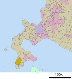 Location of Kaminokuni in Hokkaido (Hiyama Subprefecture) | |
 Kaminokuni Location in Japan | |
| Coordinates: 41°48′N 140°7′E | |
| Country | Japan |
| Region | Hokkaido |
| Prefecture | Hokkaido (Hiyama Subprefecture) |
| District | Hiyama |
| Government | |
| • Mayor | Nomoru Kudo |
| Area | |
| • Total | 547.58 km2 (211.42 sq mi) |
| Population (September 30, 2016) | |
| • Total | 5,161 |
| • Density | 9.4/km2 (24/sq mi) |
| Symbols | |
| • Tree | Thujopsis[1] |
| • Flower | Ezoyamatsutsuji |
| Time zone | UTC+9 (JST) |
| City hall address | 100 Odomari, Kaminokuni, Hiyama District, Hokkaido 049-0698 |
| Website | www |
As of September 2016, the town had an estimated population of 5,161, and a density of 9.4 per km². The total area is 547.58 km².
Geography
Kaminokuni is located on the southwest of the Oshima Peninsula and faces the Sea of Japan. Amano River flows through the central town. Esashi Line used to run along this river.
History
Strongman Takeda Nobuhiro (1431-1494), progenitor of the Kakizaki (later Matsumae) house, established a fort (tate) in Kaminokuni leading to the settlement of the area by other Wajin merchants and fishermen.
- 1879: The village of Kaminokuni was founded.[2]
- 1902: Kaminokuni Village was merged with neighboring villages to form the new village of Kaminokuni.
- 1967: Kaminokuni Village became Kaminokuni Town.
Education
- High school
- Junior high school
- Kaminokuni Junior High School (上ノ国中学校)
- Elementary school
- Kaminokuni Elementary School (上ノ国小学校)
- Kahoku Elementary School (河北小学校)
- Takisawa Elementary School (滝沢小学校)
Sister cities


Notable people from Kaminokuni
- Tatsuhiko Takimoto, author
References
External links

- Official Website (in Japanese)
| Authority control |
|
|---|
This article is issued from Wikipedia. The text is licensed under Creative Commons - Attribution - Sharealike. Additional terms may apply for the media files.