Samani, Hokkaido
Samani (様似町, Samani-chō), is a town located in Hidaka Subprefecture, Hokkaido, Japan.
Samani 様似町 | |
|---|---|
Town | |
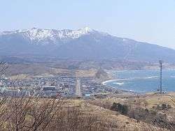 Panorama view of Mount Apoi and Samani Town | |
 Flag  Emblem | |
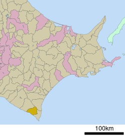 Location of Samani in Hokkaido (Hidaka Subprefecture) | |
 Samani Location in Japan | |
| Coordinates: 42°8′N 142°56′E | |
| Country | Japan |
| Region | Hokkaido |
| Prefecture | Hokkaido (Hidaka Subprefecture) |
| District | Samani |
| Area | |
| • Total | 364.33 km2 (140.67 sq mi) |
| Population (April 2017) | |
| • Total | 4,482 |
| • Density | 12/km2 (32/sq mi) |
| Symbols | |
| • Tree | Pinus parviflora Sieb. & Zucc. |
| • Flower | Callianthemum miyabeanum (ヒダカソウ, hidaka-sō) |
| Time zone | UTC+9 (JST) |
| City hall address | Ōdori 21, 1-Chōme, Samani-chō, Samani-gun, Hokkaidō 058-0014 |
| Website | www |
As of April 2017, the town has an estimated population of 4,482, with 2,242 households,[1] and a density of 12 persons per km2. The total area is 364.33 km2.
The local economy is dominated by agriculture, including breeding horses for racing, tourism and the harvesting of wild konbu.
Samani is at the end of the Wanman (ワンマン運転, Wanman Unten) train line that runs from Tomakomai.
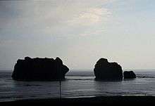
One of the best known sites in Samani is the Oya-ko rocks (親子岩, Oya-ko iwa) that sit just offshore. They are known by this name, meaning Parents-and-Child, because they are a formation of two larger rocks and smaller one. Oya-ko is nesting site for cormorants and other sea birds.
Mount Apoi (アポイ岳, Apoi-dake) is next to the town. An onsen (hot spring resort) is at the base of the mountain, which is a popular climb among tourists and locals.
References
- "Official website of Samani Town" (in Japanese). Japan: Samani Town. Retrieved 16 May 2017.
External links

- Official Website (in Japanese)
Sapporo (capital) | ||||||||||
| ||||||||||
| ||||||||||
| ||||||||||
| ||||||||||
| ||||||||||
| ||||||||||
| ||||||||||
| ||||||||||
| ||||||||||
| ||||||||||
| ||||||||||
| ||||||||||
| ||||||||||
| ||||||||||
| Authority control |
|
|---|