Ishigaki, Okinawa
Ishigaki (石垣市, Ishigaki-shi, Yaeyama: Isïgaksï, Ishanagzï) is a city in Okinawa Prefecture, Japan. It includes Ishigaki island and the disputed Senkaku Islands territory.[1] The city is the political, cultural, and economic center of the Yaeyama Islands.[2] New Ishigaki Airport serves the city.
Ishigaki 石垣市 Isïgaksï, Ishanagzï | |
|---|---|
 Top left: Mount Omoto, Top right: Mount Nosoko, 2nd row: Kabira Bay from Kabira Park, lower left: 730 Street in downtown Ishigaki, lower right: Shiraho natural reef, Bottom of left:Hirakubo peninsula from Tamatorizaki, Bottom right: Miyara old residence site | |
 Flag  Seal | |

| |
 Location of Ishigaki in Okinawa Prefecture | |
 Ishigaki | |
| Coordinates: 24°20′26″N 124°9′20″E | |
| Country | Japan |
| Region | Kyushu |
| Prefecture | Okinawa Prefecture |
| Government | |
| • Mayor | Yoshitaka Nakayama |
| Area | |
| • Total | 229.00 km2 (88.42 sq mi) |
| Population (October 1, 2016) | |
| • Total | 47,562 |
| • Density | 213/km2 (550/sq mi) |
| Time zone | UTC+9 (Japan Standard Time) |
| - Tree | Yaeyama kokutan (Diospyros ferrea) |
| - Flower | Sakishima tsutsuji (Rhododendron amanoi, Ohwi) |
| - Bird | Crested serpent eagle |
| - Butterfly | Rice paper butterfly |
| - Fish | Hamafuefuki (Lethrinus nebulosus) |
| - Shell | Black-lip oyster (Pinctada margaritifera) |
| Phone number | 0980-82-9911 |
| Address | 14 Misakichō, Ishigaki-shi 907-8501 |
| Website | www |
As of December 2012, the city has an estimated population of 48,816 and a population density of 213 persons per km2. The total area is 229.00 km2.[3]
It is also the location of the past-disputed Senkaku Islands (see below in the Geography section).
History
Ishigaki was founded in 1908 as Yaeyama Village, an amalgamation of the Ishigaki, Ōhama, and Miyara magiri. In 1914 it was renamed to Ishigaki Village, and grew to become Ishigaki Town in 1926. Ishigaki was elevated to city status on July 10, 1947.
Geography
The city of Ishigaki covers the entirety of Ishigaki Island (222 square kilometres (86 sq mi)).[4] The island is surrounded by coral reefs. The highest point on Ishigaki Island is Omotodake (525.5 metres (1,724 ft)).[5]
The uninhabited Senkaku Islands are located 150 kilometres (93 mi) north of the Ishigaki Island. The Senkaku Islands cover roughly 6.3 square kilometres (2.4 sq mi).[6][7]
Climate
Ishigaki has a tropical rainforest climate (Köppen climate classification Af) with frequent cyclones so not equatorial. "Summers" are hot and "winters" warm. Precipitation is abundant throughout the year; the rainiest months are August and September (due to tropical storm/typhoon) while the driest months are December and July.
| Climate data for Ishigaki, Okinawa | |||||||||||||
|---|---|---|---|---|---|---|---|---|---|---|---|---|---|
| Month | Jan | Feb | Mar | Apr | May | Jun | Jul | Aug | Sep | Oct | Nov | Dec | Year |
| Record high °C (°F) | 27.8 (82.0) |
29.1 (84.4) |
29.4 (84.9) |
32.9 (91.2) |
33.7 (92.7) |
34.6 (94.3) |
35.3 (95.5) |
35.6 (96.1) |
35.4 (95.7) |
33.2 (91.8) |
30.9 (87.6) |
29.0 (84.2) |
35.6 (96.1) |
| Average high °C (°F) | 21.2 (70.2) |
21.6 (70.9) |
23.5 (74.3) |
25.8 (78.4) |
28.3 (82.9) |
30.4 (86.7) |
32.0 (89.6) |
31.8 (89.2) |
30.7 (87.3) |
28.7 (83.7) |
25.8 (78.4) |
22.7 (72.9) |
26.9 (80.4) |
| Daily mean °C (°F) | 18.6 (65.5) |
19.1 (66.4) |
20.8 (69.4) |
23.3 (73.9) |
25.7 (78.3) |
28.0 (82.4) |
29.5 (85.1) |
29.2 (84.6) |
27.9 (82.2) |
25.9 (78.6) |
23.2 (73.8) |
20.1 (68.2) |
24.3 (75.7) |
| Average low °C (°F) | 16.5 (61.7) |
16.9 (62.4) |
18.5 (65.3) |
21.2 (70.2) |
23.6 (74.5) |
26.1 (79.0) |
27.6 (81.7) |
27.1 (80.8) |
25.8 (78.4) |
23.7 (74.7) |
21.1 (70.0) |
18.0 (64.4) |
22.2 (71.9) |
| Record low °C (°F) | 6.0 (42.8) |
5.9 (42.6) |
7.2 (45.0) |
10.0 (50.0) |
11.2 (52.2) |
16.5 (61.7) |
20.0 (68.0) |
17.4 (63.3) |
17.2 (63.0) |
14.0 (57.2) |
7.1 (44.8) |
6.6 (43.9) |
5.9 (42.6) |
| Average precipitation mm (inches) | 130.6 (5.14) |
139.4 (5.49) |
131.5 (5.18) |
155.1 (6.11) |
206.6 (8.13) |
206.6 (8.13) |
130.4 (5.13) |
261.6 (10.30) |
257.7 (10.15) |
204.5 (8.05) |
156.5 (6.16) |
126.3 (4.97) |
2,106.8 (82.94) |
| Average relative humidity (%) | 72 | 74 | 76 | 78 | 79 | 81 | 77 | 77 | 76 | 73 | 72 | 69 | 75 |
| Mean monthly sunshine hours | 85.9 | 82.1 | 112.0 | 125.3 | 162.3 | 208.7 | 264.5 | 235.2 | 193.6 | 158.4 | 115.8 | 100.7 | 1,844.5 |
| Source: JMA (1981-2010) [8] | |||||||||||||
Transportation
New Ishigaki Airport and Ishigaki Port serve the city.
Economy
Ishigaki produces sugarcane and pineapples. Tourism is also an important part of the economy of the city.[2]
Sights
The town of Ishigaki has various sights to offer.
- Gongen Do is a sightworthy Shinto shrine close to the center of Ishigaki town which was founded in 1614. The shrine was destroyed during a flood in 1771. The present buildings date from 1787.[9] The neighbouring building is Torin Ji, a buddhist temple which was founded in 1614 as well. It houses several statues dating from 1737 which possibly represent tutelary gods of Ishigaki Island.
- Close by is Miyaradunchi, a residential building dating from 1819. Its architecture with a hip roof consisting of red tiles is similar to samurai houses on mainland Japan, but there have never been samurai on the Yaeyama Islands.
- The Museum of the Yaeyama Islands, Shiritsu Yaeyama Hakubutsukan, is on Main Street in the center of Ishigaki town. Various kinds of boats and other items referring to the history and culture of the Yaeyama Islands can be seen. It is famous for being the southernmost museum of Japan.
- Fuzaki Kannon Do is a small Shinto shrine dating from 1742. It is 5 km west of the town on a hill offering a scenic view of Ishigaki and Iriomote, the neighbouring island.[10] The shrine is dedicated to Kannon, the Buddhist boddhisatva of mercy.
- Tojinbaka is tomb in a typical Chinese style about 6 km west the town on the ring road. 400 Chinese labourers who died during a rebellion on a ship sailing to America in 1852 are buried here.[11]
- Kabira Bay
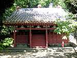 Shinto shrine Gongen Do
 Torin Ji Temple
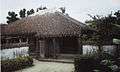 Miyara Donchi
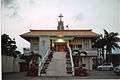 Catholic Church in Ishigaki
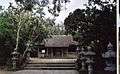 Shrine Fuzaki Kannon Do
 Tojinbaka Tomb
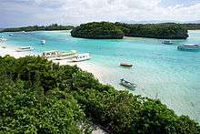 Kabira Bay
Notable people from Ishigaki
- Yukiya Arashiro (born 1984) professional cyclist
- Yudai Arashiro (born 1995) professional cyclist
- Yōkō Gushiken (born 1955) boxer
- Rimi Natsukawa (born 1973) folk singer
- Begin (band) (all members born 1968) pop musical group
Sister cities
Overseas

References
- "石垣(市)" [Ishigaki]. Nihon Daihyakka Zensho (Nipponika) (in Japanese). Tokyo: Shogakukan. 2012. OCLC 153301537. Archived from the original on 2007-08-25. Retrieved 2012-12-14.
- "Ishigaki". Encyclopedia of Japan. Tokyo: Shogakukan. 2012. OCLC 56431036. Archived from the original on 2007-08-25. Retrieved 2012-12-31.
- 石垣市の人口 [Population of Ishigaki] (in Japanese). Ishigaki, Okinawa Prefecture, Japan: City of Ishigaki. 2013. Archived from the original on 2013-01-31. Retrieved 2013-01-28.
- "平成27年全国都道府県市区町村別面積調 島面積" (PDF). Geospatial Information Authority of Japan. 2015-10-01. p. 111. Archived from the original (PDF) on 2016-06-15. Retrieved 2016-04-15.
- "Ishigakijima". Encyclopedia of Japan. Tokyo: Shogakukan. 2012. OCLC 56431036. Archived from the original on 2007-08-25. Retrieved 2012-12-14.
- "Senkaku". Encyclopedia of Japan. Tokyo: Shogakukan. 2012. OCLC 56431036. Archived from the original on 2007-08-25. Retrieved 2012-12-14.
- "尖閣諸島" [Senkaku Islands]. Nihon Rekishi Chimei Taikei (in Japanese). Tokyo: Shogakukan. 2012. OCLC 173191044. dlc 2009238904. Archived from the original on 2007-08-25. Retrieved 2012-12-07.
- "Ishigakijima Climate Normals 1981-2010" (in Japanese). Japan Meteorological Agency. Retrieved December 22, 2013.
- Chris Taylor: Japan, S. 716. Stefan Loose Verlag. Berlin 1998
- Yamakei: Ryukyu Nansei Shoto, p.106. Tokio 2003. ISBN 4-635-01718-4
- Yamakei: Ryukyu Nansei Shoto, p.105. Tokio 2003. ISBN 4-635-01718-4
External links
| Wikimedia Commons has media related to Ishigaki, Okinawa. |
| Wikivoyage has a travel guide for Ishigaki. |
- Official website

Naha (capital) | ||
| Core city | ||
| Cities |
| |
| Districts | ||
List of mergers in Okinawa Prefecture
| ||
| Authority control |
|
|---|