Hatepe eruption
The Hatepe eruption, named for the Hatepe Plinian pumice tephra layer,[1] sometimes referred to as the Taupo eruption and dated to either around 180 or 233 AD[2] was Taupo Volcano's most recent major eruption. It is considered New Zealand's largest eruption during the last 20,000 years. The eruption ejected some 120 km3 (29 cu mi) of material, of which 30 km3 (7.2 cu mi) was ejected in a few minutes. This makes it one of the most violent eruptions in the last 5000 years, comparable to the Minoan eruption in the 2nd millennium BC, the 946 eruption of Paektu Mountain and the 1815 eruption of Mount Tambora.
| Hatepe eruption | |
|---|---|
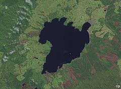 The Hatepe eruption's three main vents ran parallel to Lake Taupo's current southeastern shore. | |
| Volcano | Lake Taupo |
| Date | About 180 AD |
| Type | Phreatomagmatic, Ultra-Plinian |
| Location | Lake Taupo, North Island, New Zealand 38°49′S 175°55′E |
| VEI | 7 |
| Impact | Devastated local vegetation, expanded Lake Taupo, flooded the Waikato River |
Stages of eruption
The eruption went through several stages, with six distinct marker horizons identified. Despite the uniform composition of the erupted magma, a wide variety of eruptive styles were displayed, including weak phreatomagmatism, Plinian eruptions, and a huge pyroclastic flow. Rhyolitic lava domes were extruded some years or decades later, forming the Horomatangi reefs and Waitahanui bank.[3]
The main pyroclastic flow devastated the surrounding area, climbing over 1,500 m (4,900 ft) to overtop the nearby Kaimanawa Ranges and Mount Tongariro, and covering the land within 80 km (50 mi) with ignimbrite. Since New Zealand was not settled by the Māori until more than a thousand years later, the area had no known human inhabitants when the eruption occurred. Tsunami deposits of the same age have been found on the central New Zealand coast, evidence that the eruption caused local tsunamis, but much more widespread waves may have been generated (like those observed after the 1883 Krakatoa eruption).[4]
The Hatepe eruption further expanded the lake that had formed after the much larger Oruanui eruption around 26,500 years ago. The previous outlet was blocked, raising the lake 35 metres above its present level until it broke out in a huge flood, flowing for more than a week at roughly 200 times the Waikato River's current rate.
Dating the event
For many years it was believed, following research by Colin J. N. Wilson and others, that the eruption could be dated to exactly 186 AD.[5] This meant that it coincided with meteorological phenomena described by Fan Ye in Han China and by Herodian of Antioch in the Roman Empire.[6][7] This is now questioned.
Estimated dates previously suggested for the Taupo eruption have ranged from 131 to 233 AD. The earlier date was based on 14
C from carbonized vegetation enclosed in the eruption products. However, the 22 selected samples used to obtain an average date of 1,819 ± 17 years BP (131 AD) had much larger standard deviations than the average date itself.[7] Most if not all geologists now accept that the tephra or pumice fall from the eruption was far greater than previously thought, approximately 150 km3 (36 cu mi) instead of 14 km3 (3.4 cu mi). The later date of 233 AD ± 13 (95% confidence) was a result of radiocarbon dating by R. Sparks (1995).[2][8]. The presence of contaminating 14C-less magmatic carbon in pre-eruption groundwaters has been proposed as skewing towards older dates, leading to suggested dates for the Hatepe eruption decades or even centuries younger than previously thought.[9]
Humans had not settled in New Zealand at the time of the eruption, and would not for more than 1,000 years. The nearest human populations at the time were in Australia, more than 2,000 kilometres (1,200 mi) to the west.
References
- Talbot, J. P.; Self, S.; Wilson, C. J. N. (1994). "Dilute gravity current and rain-flushed ash deposits in the 1.8 ka Hatepe Plinian deposit, Taupo, New Zealand". Bulletin of Volcanology. 56 (6–7): 538–551. Bibcode:1994BVol...56..538T. doi:10.1007/BF00302834.
- Sparks, R. J.; Melhuish, W. H.; McKee, J. W. A.; Ogden, J.; Palmer, J. G. (1995). "14C calibration in the Southern Hemisphere and the date of the last Taupo eruption: evidence from tree-ring sequences". Radiocarbon. 37 (2): 155–163. doi:10.1017/S0033822200030599.
- Houghton, B.F. (2007). Field Guide—Taupo Volcanic Zone.
- Lowe, D. J., D.J.; de Lange, W. P. (2000). "Volcano-meteorological tsunamis, the c. AD 200 Taupo eruption (New Zealand) and the possibility of a global tsunami". The Holocene. 10 (3): 401–407. doi:10.1191/095968300670392643.
- Barton, John (2001). The First New Zealand Book?—an Eyewitness account of the Taupo eruption of AD 186. New Plymouth: Trustees of the Dalberton Library. ISBN 978-0-473-08268-0.
- Herodian of Antioch. "Chapter 14". History of the Roman Empire. Book 1.
Stars remained visible during the day; other stars, extending to an enormous length, seemed to be hanging in the middle of the sky.
- Wilson, C. J. N.; Ambraseys, N. N.; Bradley, J.; Walker, G. P. L. (1980). "A new date for the Taupo eruption, New Zealand". Nature. 288 (5788): 252–253. Bibcode:1980Natur.288..252W. doi:10.1038/288252a0.
- A continent on the move : New Zealand geoscience into the 21st century—Graham, Ian J. et al.; The Geological Society of New Zealand in association with GNS Science, 2008. ISBN 978-1-877480-00-3. page 66, 168.
- Kennedy, Ben; Duffy, Brendan; Holdaway, Richard N. (2018-10-05). "Evidence for magmatic carbon bias in 14 C dating of the Taupo and other major eruptions". Nature Communications. 9 (1): 4110. doi:10.1038/s41467-018-06357-0. ISSN 2041-1723. PMC 6173711. PMID 30291227.
External links
- Lake-floor relief map, from Dave Rowe Gavin; James Gavin Macaulay; Ude Shankar (October 2002). "Volume 10: High-tech Tools for Tackling Fisheries Problems in Lakes". Cite journal requires
|journal=(help) Summary: the main Hatepe eruption vents are marked by submarine peaks on the far side of Lake Taupo.