Viçosa, Minas Gerais
Viçosa is a Brazilian municipality in the state of Minas Gerais. Its population in July 2016 was estimated at 77,863 inhabitants.
Viçosa | |
|---|---|
Municipality | |
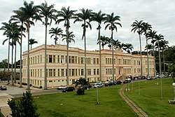 Federal University of Viçosa - Main Building | |
 Flag  Seal | |
| Nickname(s): College Town | |
| Motto(s): Culture and civility | |
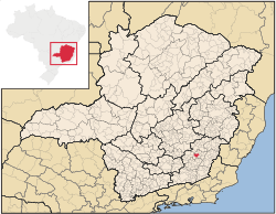 Location of Viçosa in the state of Minas Gerais | |
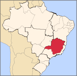
 Viçosa Location of Viçosa in Brazil | |
| Coordinates: 20°45′14″S 42°52′55″W | |
| Country | |
| Region | Southeast |
| State | |
| District | 10/13/1831 |
| Village | 09/30/1871 |
| County | 1/20/1873 |
| Government | |
| • [Mayor] | Ângelo Chequer (PSDB) |
| • [Deputy mayor] | Arnaldo Dias de Andrade PSB |
| Area | |
| • Total | 299.397 km2 (115.598 sq mi) |
| Elevation | 648 m (2,126 ft) |
| Population (2010)[1] | |
| • Total | 72,220 |
| • Estimate (2018)[2] | 78,286 |
| • Density | 240/km2 (620/sq mi) |
| Time zone | UTC-3 |
| • Summer (DST) | UTC-2 |
| Area code(s) | +55(31) |
| Website | www |
It is a city essentially oriented to education, with emphasis on the Federal University of Viçosa, founded in 1926 by the president of the Republic Arthur da Silva Bernardes, who was born in Viçosa. It also possesses other private higher education institutions, emphasizing the educational character of the city. It is a city that attracts many people from Brazil and other countries due to scientific and academic events that take place around the university, totaling approximately 500 annual events.
History
Foundation
Before colonization, the area of the Piranga River basin was inhabited by Botocudos and Puris Indians, who with the Tamoios belonged to the Tupi group. Although traversed by some bandeirantes in century XVII remained occupied by natives until then.
The white-European settlement of the region began in the eighteenth century by the settlements located on the banks of the Caminho Novo (New Path) - a road opened by the colonial government for gold to be taken straight from the Minas region to Rio de Janeiro, shortening the route and maintaining its monopoly, which used to be made through the Mantiqueira canyons, passing through the Serra do Mar and the bay of Ilha Grande, on the São Paulo coast, only to reach Rio de Janeiro. This settlement occurred at first timidly, since the Portuguese Crown prohibited the occupation of the "Sertões of East" region.
With the decay of the gold production in Minas Gerais, several explorers and their families moved from the mining towns to the Zona da Mata. This region was considered as an agricultural frontier, without major white-European housing outbreaks until the first half of the eighteenth century.
The current northern region of Zona da Mata would be populated by white-Europeans with the encouragement of the governor of the captaincy of Minas, who, around 1781, distributed to this privileged population hundreds of sesmarias destined to the search for gold. Population was strongly boosted throughout the nineteenth century by the expansion of coffee plantations. Besides this, other economic activities have developed, such as trade and other services associated with its cultivation, still under the regime of enslavement of black and indigenous people.
The white-European occupation of Viçosa began properly in the nineteenth century. On March 8, 1800, Father Francisco José da Silva obtained permission from the bishop of Mariana - Frei Cipriano to erect a hermitage in honor of Rita of Cascia Saint , where the chapel of Our Lord of Passos is situated today at Passos Street, center of the host district - this region became the patrimony of Rita of Cascia Saint. The construction of the chapel is the starting point of the process of occupation provided by the Catholic Church, to the detriment of other religious manifestations, which would become the town of Santa Rita do Turvo (Rita Saint of Turbid), toponym of the hermitage that marked the beginning of the town plus the name of the main river that crosses the locality - Turvo.
In 1813, with the increase of the town it was decided to construct a new catholic temple in the place of the present Place Silviano Brandão. The construction of a new catholic church to the holy patron saint in another place caused the axis of urban expansion to move towards a flatter area, near the São Bartolomeu Riverside valley, with better conditions to erect new buildings, favoring the growth of the town .
On October 13, 1831, the current town of Rio Pomba, 100 km from Viçosa, was elevated to the category of village, passing Santa Rita do Turvo to be one of its 14 initial districts (in 1837 they reached 20).
The initial layout of the city center has hardly changed over time, even with the local expansion and creation of new streets. However, by the end of the 19th century, the territory of Santa Rita do Turvo was significantly parceled out. The town was divided into three regions: The Patrimony of Santa Rita (Rita of Cascia), in Rua dos Passos; the Patrimony of the Mother Church, where the current sanctuary and the block between the streets Senador Vaz de Mello and Arthur Bernardes, Rosário Square, going from São Bartolomeu Stream to Conceição Stream; and the patrimony of San Francisco that covered the area where the Dr. Cristóvão Lopes de Carvalho Square, Padre Serafim Street and the Dom Viçoso Cemetery are currently located.
According to José Mário Rangel, on July 14, 1832 the district of Santa Rita do Turvo disembarked from the parish of Pomba and became a parish. On August 31, 1833 was founded the Parish of Santa Rita, which at the time was also a political division. In 1851 was inaugurated the first Church Matrix, built on the old necropolis that was in front of the chapel located in what today is the Place Silviano Brandão, having the dismantle of the same after finishing of the work.
As a result of Provincial Law No. 1,871, of September 30, 1871, Santa Rita do Turvo was elevated to a village of the same name. It was constituted then of five districts: Santa Rita do Turvo (headquarters), São Sebastião dos Aflitos de Arrepiados and Curato de Coimbra (dismembered from the municipality of Ubá), São Miguel do Anta (dismembered from Ponte Nova) and Barra do Bacalhao dismembered from Mariana). The town was elevated to the category of city, municipality, effectively, three years later (June 3, 1876), with the name of Viçosa de Santa Rita, in honor of the 7th Bishop of Mariana, Dom Antônio Ferreira Viçoso. On January 22, 1873, the installation of the municipality was inaugurated, with the inauguration of the building to be the headquarters of the Chamber and Chain, at the place where today is the property number 136 of the current Place Silviano Brandão, on the right corner with Rua dos Passos. The Chamber began functioning on April 12, 1877, when Brazil was still ruled by Dom Pedro II. Its first president was the Councilman Carlos Vaz de Mello, that later became senator of the Empire.
By provincial law nº 3171, of October 18, 1883, and state law nº 2, of September 14, 1891, the district of Santo Antônio dos Teixeiras was created and attached to the municipality of Viçosa de Santa Rita. By Provincial Law 3387, of July 10, 1886, the district of São Sebastião dos Aflitos de Arrepiados was renamed São Sebastião do Erval. By state decree nº 227, of November 6, 1890, and state law nº 2, of September 14, 1891, the district of São Vicente do Grama was created and attached to the municipality of Viçosa de Santa Rita
On December 21, 1885, during the administration of Arthur Bernardes, the then president of the City Council of Viçosa by two legislatures, Carlos Vaz de Mello, managed by its political influence that the railroad arrived in Viçosa. The arrival of the "iron train" of the Leopoldina Railway, whose station was six kilometers from Viçosa - at what is now called Estação Velha or Estação de Silvestre - was the landmark of the arrival of developmental progress to the city.
In 1911 the municipality would be called only from Viçosa.The distance from the train station in the city center made it difficult to board and disembark passengers, since it was only possible to get there by ox cart, carriages and other means. This situation lasted for almost 30 years, until the Leopoldina station was transferred to the city center, and its inauguration took place on August 21, 1914, when the local population had already reached two thousand inhabitants. From there the city was finally linked to the capital of the country, Rio de Janeiro. With the construction of the railway station near the central part of the city, consolidated by the construction of the new Mother Church of Santa Rita, the center expanded its scope and in the surroundings of the same began to establish commerce, hotels and new residences, mainly of architectonic style eclectic. The growth around the railway station is a common reference between the cities of Zona da Mata, Minas Gerais.
With this new connection between the city of Viçosa and the coast, the first families who would form the Lebanese and Italian colony of the municipality arrived in cities. Some Lebanese came as peddlers and began trading in fabrics, haberdashery and footwear, which was an inexpressive trade until the mid-twentieth century. Also at the same time came the first Italians, who were mostly craftsmen, tailors, caldereiros. Although small, along with the black population, these nuclei participated actively in the formation of Viçosa. They brought their customs, their beliefs and their values, enriching the local cultural patrimony.
In 1908 was founded the House of Charity of Viçosa, which today is the Hospital São Sebastião (initially installed at Av. Bueno Brandão, only moving to the present place at Rua Tenente Kummel, with the end of the construction of the building in 1930 ). In 1922 the Regional Hospital was inaugurated at Afonso Pena Street (as part of the Public Health Plan, then President of the State of Minas Gerais, Dr. Arthur Bernardes).
In 1913, a private company was founded with capital consisting of quotas, with the name of Gymnasio de Viçosa (institution that gave rise to the current State School Doctor Raimundo Alves Torres - ESEDRAT), in Silviano Brandão Square. In 1917 the Nossa Senhora do Carmo Normal School was founded in Viçosa (now the Carmo College) run by the Carmelite Sisters of Divine Providence and was attached to it for a short time before separating and dedicating themselves exclusively to education female. Most significantly, both have become high school quality references in the city and region.
A Escola Superior de Agricultura e Veterinária (The Higher School of Agriculture and Veterinary Science), ESAV, was founded in 1926, by the then president of Brazil and former mayor of viçosa, Arthur da Silva Bernardes. He participated in his construction, hired as assistant engineer, João Carlos Bello Lisboa. Its first director was Professor Peter Henry Rolfs, who brought a model of education applied in schools in Florida, United States, based on the triple "Teaching, Research and Extension" that soon spread throughout the rest of the country. In the year of 1948 the Superior School became Universidade Rural do Estado de Minas Gerais, (Rural University of the State of Minas Gerais), UREMG. In 1969, it was federalized, becoming the Federal University of Viçosa Foundation. Significant events for the history of the institution are reflected in the growth of the municipality - important personalities for the upper school are also important personalities for Viçosa. Its implantation within the urban perimeter constitutes a factor of crystallization in one of the vectors of growth of the city. The institution starts attracting people in search of jobs and brings students and teachers from various places in the country, promoting the growth and expansion of the city.
In the decade of 1950 the city underwent significant works of redevelopment, as well as the construction of important buildings. PH Rolfs and Santa Rita avenues were renovated, the old city hall building (located in Praça do Rosário) was completed and the Cine Brasil building (corner of Praça do Rosário with Rua Padre Serafim) was built, which would become a cultural reference for decades . The construction of the Colégio de Viçosa (Current Headquarters of the City Hall) was begun. The squares of the Rosário and Silviano Brandão were redesigned and the new Mother Church of Santa Rita was erected, next to the old one. The construction of the new Catholic temple, much larger and more solid than the previous one, at that time, is given as "landmark for the progress and expansion of the municipality".
In territorial division dated December 31, 1963, the municipality is constituted of three districts: Viçosa, Cachoeira de Santa Cruz and Silvestre. Law no. 001/92, dated January 14, 1992, created the district of São José do Triunfo. Currently, the Municipality of Viçosa has four districts: Viçosa (Headquarters), Cachoeira de Santa Cruz, São José do Triunfo and Silvestre.
The process of occupying the urban space of the city is closely linked to the implementation of the Federal University of Viçosa (UFV). Initially the institution itself took care of the students' housing demand, building, in the 1920s, the first accommodation (now also known as old housing) and in the late 1960s the female housing. At that same time Vila Giannetti was implanted in the campus of the university, destined to the dwelling of teachers, bringing to the city one of the rare examples of modernist urbanism existing in the interior of the country.
From the federalization of the institution in 1969 and the creation of new courses in the 1970s, there was a change in the daily life of the city, which started to have its dynamics developed due to the University. At that time, the students were no longer fully served by the university's own housing, and eventually settled in the center of the city in pensions or in the so-called republics (where is the residence of a group of students) because of the proximity of the area to the campus.The process of densification of the center and the neighborhoods close to it was intensified. The presence of buildings in the central area marked this decade, as well as the process of verticalization of the Ramos neighborhood, in its lower part near the center, and in the beginning of the Clélia Bernardes neighborhood, mainly along the Avenue Olívia de Castro Almeida.Paralelamente to this fact, teachers began to look for areas far from the city center, thus creating the first horizontal condominiums, such as the condominium Residencial Bosque do Acamari in 1983. It also marks the beginning of the verticalization process, with buildings with up to four floors. The verticalization trend continues in the neighborhood Ramos and Clélia Bernardes, as well as in the area of Silviano Brandão Square, Santa Rita Avenue and Rua Gomes Barbosa. Also, during this period, the first buildings of commercial use and services appeared. The Panorama building, 12 stories high, was the first to have elevators in the city, still in the 1970s.
The absence of passenger trains since the 1980s encouraged the deactivation of the line in 1994, in the stretches Três Rios - Liaison and Ponte Nova - Caratinga.
In the 1990s, the Center's verticalization process intensified, with taller buildings, with a total of about 10 floors. However, with the lack of land in the center proper and the role of UFV induction, the tendency to verticalization moves to Av. PH Rolfs and its surroundings, Ladeira dos Operários and José Antônio Rodrigues Street, near the "Four Pilasters ", As well as Santa Rita Avenue and Gomes Barbosa Street. It is also in the 90's that the neighborhoods of Fatima, Lourdes, São Sebastião, Santo Antônio, João Braz, among others, began to verticalize, although with smaller jigs, around five floors.
Since 2001, private higher education institutions, close to the BR-120, have been installed in the city, establishing a new urban growth vector. The installation of these institutions reinforce the vocation of the service sector. Historical facts linked to UFV directly influenced the historical and social evolution of the municipality.
The process of verticalization of the city and the unbridled arrival of new students caused, in addition to structural problems, complaints by the people of Vicosense about the quality of life. On March 17, 2011, after several popular demonstrations about non-compliance with the law of silence, it was imposed that nocturnal establishments that have sound insulation could only work until 3 o'clock, the others should close until 2 o'clock, as stated in the Code of Postures of the Municipality of Viçosa.
The local economy, based on the services sector, is dependent on the floating population, which resides mostly during the school period in the city. The urban expansion happens in an organic way, adding to already saturated regions and with an old infrastructure. There are currently discussions in society about the benefits and harms of not controlling the local growth model. There are problems of rainwater drainage, transportation, paving, occupancy in hazardous areas, suppression of water courses, visual pollution, sewage and water supply system, and problems with electricity supply. The University participates in the discussions, since it directly influences the city.
Despite the urban problems, the municipality stands out as a micro-regional pole, meeting a demand of almost 200 thousand inhabitants that resort to Viçosa in the search for health, education and commerce services. The municipality has become a cultural reference when promoting large events. In addition, research conducted by higher education institutions takes the name of the city to become scientific reference.
In April 2011 was inaugurated the Technology Park of Viçosa - TecnoParq - which is a partnership of UFV, Minas Government and City Hall. The Viçosa Technological Park, the first in Minas Gerais, has been under development since the beginning of the 2000s, with several incubated companies, as well as numerous already developed actions. With the inauguration of the headquarters, now has a space more appropriate to the development of ideas, which makes a technological park different from an industrial one. TecnoParq is housed in the revitalized and expanded facilities of the former Arthur Bernardes Agricultural School, linked to the extinct National Foundation of Child Welfare (Funabem). The facilities are located on the banks of the BR-120, about 5 kilometers from the campus of UFV
References
Capital: Belo Horizonte | |||||||||||||||||||||||||
|  | ||||||||||||||||||||||||
|
| |||||||||||||||||||||||||
| |||||||||||||||||||||||||
| |||||||||||||||||||||||||
| |||||||||||||||||||||||||
| |||||||||||||||||||||||||
| |||||||||||||||||||||||||
| |||||||||||||||||||||||||
| |||||||||||||||||||||||||
| |||||||||||||||||||||||||
| |||||||||||||||||||||||||