Montes Claros
Montes Claros is a city located in northern Minas Gerais state, in Brazil. The population is 394,350 (2015 est.) in an area of 3569 km².[5] It was made a seat of a municipality in 1831 and attained city status in 1857.
Montes Claros | |
|---|---|
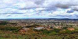 Partial view of Montes Claros | |
 Flag  Coat of arms | |
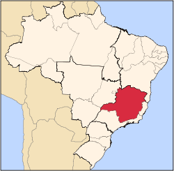
 Location in Minas Gerais state | |
 Montes Claros Location in Brazil | |
| Coordinates: 16°43′50″S 43°51′50″W | |
| Country | Brazil |
| Region | Southeast |
| State | Minas Gerais |
| Mesoregion | Norte de Minas |
| Microregion | Montes Claros |
| Government | |
| • Mayor | Humberto Guimarães Souto (PPS) |
| Area | |
| • Total | 3,568.941 km2 (1,377.976 sq mi) |
| Elevation | 678 m (2,224 ft) |
| Population (2014)[2] | |
| • Total | 390,212 |
| • Density | 110/km2 (280/sq mi) |
| Demonym(s) | Montes-clarense[3] |
| Time zone | UTC-03:00 (BRT) |
| • Summer (DST) | UTC-02:00 (BRST) |
| Postal code | 39400-000 |
| Area code | 38 |
| HDI (2010)[4] | 0.770 |
| Website | www |
History
The region was originally inhabited by the Anais and Tapuias Amerindians. The first Portuguese settlers arrived in this region during the eighteenth century. In 1707 they formed three great ranches: Jaiba, Olhos d'Água and Montes Claros. The latter was created by Antônio Gonçalves Figueira. In order to get his cattle to market Figueira opened up roads to Tranqueiras in Bahia and to the São Francisco River Soon the Fazenda de Montes Claros became the greatest producer of cattle in the north of Minas Gerais, and a small village was formed. It was officially founded in 1738 with as Arraial de Formigas. Later it would be renamed to Arraial de Nossa Senhora da Conceição and São José de Formigas. In 1768 the Espinosa-Navarro expedition, composed of twelve Bandeirantes. The settlers moved north from the coast in search of diamonds and gold in the streams, and to conquer the region from the native Amerindians.
In 1810 the town was made a bishopric. In 1831 the settlement had grown to a village and was renamed to Vila de Montes Claros de Formigas. In 1847 the first doctor arrived and set up practice. By 1857, Vila Montes Claros de Formigas had around 2,000 inhabitants and became the city of Montes Claros.
The 20th century brough fast development to the city. In 1912 the first telephone line was installed. In 1914 the first cinema (Cinema Recreio) was created. Electricity arrives in 1917. The first automobile arrives in 1920. In 1926 the first railroad service starts to operate. In 1938 the city implements a drinking water system. Finally in 1956 the city is connected to the national telephone system.
Neighboring municipalities
- North: São João da Ponte
- Northeast: Capitão Enéas
- East: Francisco Sá
- Southeast: Juramento, Glaucilândia
- South: Bocaiúva
- Southwest: Claro dos Poções
- West: São João da Lagoa, Coração de Jesus
- Northwest: Mirabela, Patis
Microregion of Montes Claros
Montes Claros is also a statistical microregion (number 36) consisting of 22 municipalities: Brasília de Minas, Campo Azul, Capitão Enéas, Claro dos Poções, Coração de Jesus, Francisco Sá, Glaucilândia, Ibiracatu, Japonvar, Juramento, Lontra, Luislândia, Mirabela, Montes Claros, Patis, Ponto Chique, São João da Lagoa, São João da Ponte, São João do Pacuí, Ubaí, Varzelândia, and Verdelândia. The population was 501,480 in 2000 and the area was 22,322.10 km². See Citybrazil
Distances
It is 418 km. from the capital, Belo Horizonte, and is connected by the following highways:
- BR 135 – Bocaiúva/Januária
- BR 365 – Pirapora/Uberlândia
- BR 251 – Rio-Bahia/Salinas/Coração de Jesus
- BR 122 – Janaúba
Climate
The climate is tropical with an annual average temperature of 24.2°C. The vegetation of the municipality is mainly Cerrado with areas of transition between cerrado and Caatinga.
Economy
- Primary sector:
Producer of dairy and beef cattle, followed by agriculture: beans, corn, manioc, cotton, and irrigated rice.
- Secondary sector:
The industrial sector began to increase with the arrival of electric power in 1965 and the participation of the government agency SUDENE in the industrial development of the region. Today industry is the main activity in the city. The factories installed are, among others, the largest factory of condensed milk in the world (Nestlé), one of the three factories of insulin in Latin America (BIOBRAS now Novo Nordisk Produção Farmacêutica do Brasil), a modern textile factory (COTENOR), and the seventh largest cement factory in Brazil (LAFARGE BRASIL)
Montes Claros is also recognized nationally as the capital of Carne de Sol, a local jerky-like dry beef and Arroz com Pequi, a very popular meal that is made of rice and Pequi. According to CAGED (Cadastro Geral de Empregados e Desempregados), Montes Claros is ranked #3 in the list of the cities of the state of Minas Gerais in number of employed people, only behind Belo Horizonte and Uberlândia.
Education and Health
Several higher education institutions are located in Montes Claros. There are three public universities: Universidade Estadual de Montes Claros (Unimontes), Instituto Federal do Norte de Minas Gerais (IFNMG) and a campus of the Universidade Federal de Minas Gerais (UFMG), and five private colleges: Universidade Paulista (UNIP), Universidade Norte do Paraná (Unopar), Faculdades Pitágoras, Faculdades Unidas do Norte de Minas (FUNORTE), Faculdade de Ciência e Tecnologia de Montes Claros (Facit), Faculdade de Saúde Ibituruna, and Faculdades Santo Agostinho.
In 2005 there were 1 public and 2 private hospitals with 996 beds. There were also 62 public and 78 private clinics.
Airport
Mário Ribeiro Airport has a runway with capability to receive planes as large as Boeing 737. It has a navigation system and a rescue and fire combat system. There are 8 daily flights to Belo Horizonte.
Municipal Human Development Index
- MHDI: .784 (2000)
- State ranking: 102 out of 853 municipalities
- National ranking: 968 out of 5,138 municipalities
- Life expectancy: 72
- Literacy rate: 90 For the complete list see Frigoletto
Tourism
Montes Claros has innumerous caves and 164 cataloged archaeological sites, among which the most important are the caves of Lapa Grande, where there is an underground river with a length of more than one kilometers. Lapa Grande is located in the Serra da Vieira, 12 kilometers from Montes Claros.
In the city itself there are several large parks, among which the most important are Parque Municipal Milton Prates, with a lake and zoo. In the rural area there is Parque Sapucaia, a forest reserve and Parque Guimarães Rosa along the banks of the Córrego Carrapato.
Notable people from Montes Carlos
- Ronildo Pereira de Freitas (born 1977), football player
- Darcy Ribeiro, anthropologist
- Yara Tupynambá (born 1932), artist
- Hydration, Overwatch League player for the Houston Outlaws
References
- "Área territorial oficial" [Official Territorial Area] (in Portuguese). Brazilian Institute of Geography and Statistics (IBGE). 2002-10-10. Retrieved 2014-12-03.
- "Estimativas de população para 1º de julho de 2014" (in Portuguese). Brazilian Institute of Geography and Statistics (IBGE). Retrieved 2014-12-03.
- "IBGE - Cidades@". O Brasil Município por Município. Brazilian Institute of Geography and Statistics (IBGE). Retrieved 2015-05-27.
- "Ranking decrescente do IDH-M dos municípios do Brasil" [Ranking of HDI-M of Brazilian Municipalities] (PDF) (in Portuguese). United Nations Development Programme (UNDP). 2010. Retrieved 2013-08-03.
- Instituto Brasileiro de Geografia e Estatística
External links
Capital: Belo Horizonte | |||||||||||||||||||||||||
|  | ||||||||||||||||||||||||
|
| |||||||||||||||||||||||||
| |||||||||||||||||||||||||
| |||||||||||||||||||||||||
| |||||||||||||||||||||||||
| |||||||||||||||||||||||||
| |||||||||||||||||||||||||
| |||||||||||||||||||||||||
| |||||||||||||||||||||||||
| |||||||||||||||||||||||||
| |||||||||||||||||||||||||