Hochelaga Archipelago
The Hochelaga Archipelago (French: Archipel d'Hochelaga), also known as the Montreal Islands, is a group of islands at the confluence of the Saint Lawrence and Ottawa rivers in the southwestern part of the province of Quebec, Canada.
| Native name: Archipel d'Hochelaga | |
|---|---|
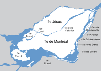 Map of the Hochelaga Archipelago | |
| Geography | |
| Location | Saint Lawrence River |
| Coordinates | 45°32′58″N 73°39′02″W |
| Total islands | 234 |
| Major islands | Île de Montréal, Île Jésus, Île Perrot, Île Bizard |
| Highest elevation | 234 m (768 ft) |
| Highest point | Mount Royal (Island of Montreal) |
| Administration | |
Canada | |
| Province | Quebec |
| City | Montreal |
| Additional information | |
| Discovered in 1535 by Jacques Cartier | |
Size
Estimates of the number of islands in the archipelago vary. The most widely accepted number seems to be 234,[1] although the number has been put as high as 325.[2]
Islands
The largest island in the group is the Island of Montreal, which contains most of the city of Montreal and the central section of its metropolitan area. The city has jurisdiction over 74 smaller islands in the archipelago, most notably Nuns' Island, Île Bizard, and the two islands that served as the site of Expo 67, namely Saint Helen's Island and the artificial Île Notre-Dame.
The second-largest island in the archipelago is Île Jésus, which along with the Îles Laval and several smaller islands makes up the city of Laval.
Other islands include the Îles de Boucherville, featuring a Québec National Park, Île Perrot, Salaberry-de-Valleyfield and the neighbouring Grande-Île, as well as the smaller Dorval Island and Dowker Island.
List of named islands
- Île à l'Aigle
- Île Avelle
- Île Barwick
- Île Béique
- Île Bellevue
- Île Bizard
- Île au Bois Blanc
- Île Bonfoin
- Îles de Boucherville, including:
- Île Charron
- Île de la Commune
- Île Dufault
- Île Grosbois
- Île Lafontaine
- Île Montbrun
- Île à Pinard
- Île Saint-Jean
- Île Sainte-Marguerite
- Île Tourte Blanche
- Île Bourdon
- Île Boutin
- Île Cadieux
- Île aux Canards
- Île aux Chats
- Île aux Cerfeuils
- Île aux Chèvres
- Île aux Plaines
- Île Claude
- Île Daoust
- Île Deslauriers
- Île Dixie
- Île Dorval
- Île Dowker
- Île au Foin
- Île Gagné
- Île Hiam
- Île Hog
- Île Jasmin
- Île Jésus
- Île Lamontagne
- Île Lapierre
- Îles Laval, including:
- Île Bigras
- Île Pariseau
- Île Ronde
- Île Verte
- Île Madore
- Île Ménard
- Île Mercier
- Île Migneron
- Île Mitan
- Île de Montréal
- Île du Moulin de Saint-François
- Île aux Moutons
- Île Notre-Dame
- Îles de la Paix, including:
- Île au Diable
- Île du Docteur
- Île à Tambault
- Île à Thomas
- Île aux Veaux
- Île Paton
- Île aux Plaines
- Île Perrot
- Île Perry
- Île de Pierre
- Île aux Pins
- Île aux Pruches
- Îles des Rapides de Lachine or Îles du Sault-Saint-Louis, including:
- Île aux Hérons
- Île aux Chèvres
- Île au Diable
- les Sept-Soeurs
- Île aux Sternes
- Île Roussin
- Île de Roxboro
- Île Saint-Joseph
- Île Saint-Laurent
- Île Sainte-Hélène
- Île Saint-Pierre
- Île Sainte-Thérèse
- Île Serre
- Île des Sœurs
- Île Sunset
- Île Todd
- Île aux Tourtes
- Île du Tremblay
- Île à la Truie
- Île aux Vaches
- Îles de Varennes
- Île Vert
- Île de la Visitation
- Île Wight
Name
The archipelago takes its name from Hochelaga, an Iroquoian settlement on the Island of Montreal that was later settled by the French and grew to become the modern city of Montreal.
References
- "Encyclopædia Britannica". Online encyclopedia. Retrieved 2008-01-11.
- "International Council on Monuments and Sites". 2000 Report on Canada. Retrieved 2008-01-11.
| Features |  | ||||||
|---|---|---|---|---|---|---|---|
| History | |||||||
| Geography | |||||||
| Economy |
| ||||||
| Politics | |||||||
| Public services | |||||||
| Education |
| ||||||
| Culture |
| ||||||
| Transportation |
| ||||||
| |||||||