U.S. Route 311
U.S. Route 311 is a United States highway that runs for 62 mi (100 km) from Winston-Salem, North Carolina to near Danville, Virginia. Along the route, it connects the cities of Winston-Salem, Madison, and Eden. The route runs northeast from Winston-Salem to Danville.
| |||||||
|---|---|---|---|---|---|---|---|

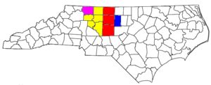
US 311 highlighted in red; former segment from 1973–2019 highlighted in blue | |||||||
| Route information | |||||||
| Length | 62 mi[1] (100 km) | ||||||
| Existed | 1927–present | ||||||
| Major junctions | |||||||
| South end | |||||||
| |||||||
| North end | |||||||
| Location | |||||||
| States | North Carolina, Virginia | ||||||
| Counties | NC: Forsyth, Stokes, Rockingham VA: Pittsylvania | ||||||
| Highway system | |||||||
| |||||||

U.S. 311 begins in Winston-Salem, at US 52 (exit 110B) in the downtown area, and proceeds northeast of the city. Starting in the vicinity of Madison, US 311 follows a number of different North Carolina state highways in short succession along with another major US Highway, US 220 before crossing the Virginia line. In Virginia, the route terminates shortly after crossing the border at the western end of the Danville Expressway.
In May 2018, North Carolina applied for, and received, permission from AASHTO to remove US 311 from the southernmost 37 miles (60 km) of the route, bringing it to its current routing from Winston-Salem to Danville.
Route description
_at_U.S._Route_58_Business_(Martinsville_Highway)_in_Callahans_Hills%2C_Pittsylvania_County%2C_Virginia.jpg)
US 311 begins at exit 110B from the US 52/NC 8 freeway in Winston-Salem, NC and leads into the downtown area. It follows N Martin Luther King Jr Dr for a short time before continuing northeast along New Walkertown Road. It travels northeast and intersects NC 66 at the edge of Walkertown, then turns to follow Harley Drive and turns again to follow Main Street through town. Leaving Walkertown, the road takes the local name of Walnut Cove Road. At the southern edge of the town of Walnut Cove NC 65 joins for a short 0.7 miles (1.1 km) concurrency. At the northern boundary of Walnut Cove, NC 89 has its terminus at US 311, and the highway turns northeast. North Carolina Highway 772 terminates at US 311 near Pine Hall and entering the town of Madison, US 311 takes an easterly route, meeting up with NC 704 along the way. East of Madison, it leaves NC 704 and joins with the Future Interstate 73/US 220 by-pass briefly to Mayodan, then leaving the freeway, it joins with NC 135 towards Eden. Three other NC routes join with 311 in Eden in short succession: NC 770, NC 87 and NC 14, then the 4 joined routes cross the Dan River along Van Buren Street in Eden. US 311 leaves Van Buren Street on a grade-separated interchange onto Meadow Road near the Eden Mall, heading northeast into a rural area before crossing into Virginia.
After the passing through the small communities of Berry Hill and Buford, it turns due west joining US 58 Business before the northern terminus of US 311 occurs at US 58, west of Danville at the western end of the Danville Expressway.
History

Established as an original U.S. Route in 1927, it originally traversed from West End, through Asheboro, High Point, Winston-Salem, Madison, and Stoneville, before entering Virginia and continuing to Roanoke, where it reached its parent route, U.S. 11. The alignment followed part of what was NC 70 and all of NC 77, both of which were decommissioned in 1934.
In 1933, US 311 was extended south through Pinehurst, Aberdeen, and Laurinburg, to Rowland, overlapping NC 241. A year later, US 220 was established and replaced US 311 south of Asheboro and north of Madison, severing the connection with its parent route. Sections further south were replaced by NC 2 (today's NC 211) and US 501. Later in 1966, US 311 was truncated in Randleman; by 1973, US 311 southern terminus was moved to US 220 Bypass, in Randleman.[3]
By 1952, US 311 was rerouted west of downtown Winston-Salem, following Waughtown Road, Stadium Drive, Claremont Avenue and 7th Street, to New Walkertown Road. In the mid-1980s, US 311 was moved onto new freeway through southeast Forsyth County. In 1996, the route through Winston-Salem changed again, going west on Interstate 40 then north along US 52/NC 8 to Martin Luther King Jr. Drive then east onto New Walkertown Road.[4]
In 1997, the first section of the East Belt was opened in High Point, rerouting US 311 onto the new freeway to Eastchester Drive then back into downtown High Point with concurrency with North Carolina Highway 68. The old alignment along North Main Street became US 311 Business. On November 20, 2004, the second section of the "East Belt" was opened, rerouting US 311 to I-85 Bus./US 29/US 70. On November 22, 2010, the third and final section of the "East Belt" was completed, linking Interstate 85; Also Interstate 74 was established as an concurrency of US 311 from Cedar Square Road to North Main Street.[5][6]
In September 2003, US 311 was extended north from Madison to NC 14/NC 87/NC 770 in Eden, via US 220 and NC 135. The extension was finally signed in August 2011.[3] The route was approved by American Association of State Highway and Transportation Officials (AASHTO) in November 2012, after an initial request by officials in Eden, to be extended to US 58 in Virginia; which in January 2013, NCDOT signed-off on extending the route and replacing parts of NC 700 and NC 770.[7][8][9] US 311 was signed in the field in Virginia, from Danville south to the state line (replacing secondary State Route 863) in September 2013.
Since 2003, a project called the "US 311 Connector" has been planned by NCDOT and the city of Winston-Salem. Estimated at $23.5 million (2003 dollars), the 2.8-mile (4.5 km) four-lane urban boulevard would connect between I-40 (exit 196) and I-40 Business (exit 8), linking US 311 with US 158 (Reidsville Road); it also included a landscaped medium with walking/bicycle trails parallel to it. By 2016, the project has ceased appearing in the State Transportation Improvement Program (STIP), though still part of the Winston-Salem 2035 Transportation Plan.[10][11]
In May 2018, AASHTO approved a request by NCDOT to eliminate 37.03 miles (59.59 km) between Randleman and Winston-Salem, moving the southern terminus from I-73 in Randleman to Martin Luther King, Jr. Boulevard in Winston-Salem, as all but 7.27 miles (11.70 km) of this section is freeway which already has other primary designations; those non-redundant sections would be reassigned secondary North Carolina routes.[12] In January 2019, NCDOT officially eliminated the section.[13]
Junction list
| State | County | Location | mi[1][14] | km | Destinations | Notes | |
|---|---|---|---|---|---|---|---|
| North Carolina | Forsyth | Winston-Salem | 37.5 | 60.4 | Southern terminus | ||
| Walkertown | Future Winston-Salem Northern Beltway[15] | ||||||
| 44.0 | 70.8 | ||||||
| Stokes | Walnut Cove | 52.8 | 85.0 | West end of NC 65 overlap | |||
| 53.5 | 86.1 | East end of NC 65 overlap | |||||
| 55.2 | 88.8 | ||||||
| Pine Hall | 60.8 | 97.8 | |||||
| Rockingham | Madison | 67.5 | 108.6 | North end of US 220 Business overlap, west end of NC 704 overlap | |||
| 69.0 | 111.0 | South end of US 220/US 220 Business overlap, east end of NC 704 overlap | |||||
| Mayodan | 72.0 | 115.9 | North end of US 220 overlap, west end of NC 135 overlap | ||||
| Eden | 81.0 | 130.4 | East end of NC 135 overlap, west end of NC 770 overlap | ||||
| 83.6 | 134.5 | South end of NC 87 overlap | |||||
| 85.2 | 137.1 | South end of NC 14 overlap | |||||
| 87.7 | 141.1 | North end of NC 14/NC 87 overlap, east end of NC 770 overlap | |||||
| 89.0 | 143.2 | ||||||
| 94.8 0.0 | 152.6 0.0 | North Carolina–Virginia state line | |||||
| Virginia | Pittsylvania | Bachelors Hall | 7.5 | 12.1 | Northern terminus | ||
1.000 mi = 1.609 km; 1.000 km = 0.621 mi
| |||||||
Special routes
High Point business loop
| |
|---|---|
| Location | High Point, North Carolina |
| Length | 6.0 mi[16] (9.7 km) |
| Existed | 1997–2009 |
Established in 1997, when mainline US 311 was placed on new freeway east of High Point, it was 2 miles (3.2 km) long following North Main Street from US 311 to Eastchester Drive. On December 2005, US 311 Business was extended south, through the downtown area, to I-85 Bus./US 29/US 70. However, on November 23, 2009, US 311 Business was decommissioned, a couple of years before the completion of the "East Belt."[5][17][18]
References
- Google (July 2, 2011). "US 311" (Map). Google Maps. Google. Retrieved July 2, 2011.
- "North Carolina Memorial Highways and other Named Facilities" (PDF). Retrieved August 26, 2012.
- "End of US Highway 311". Retrieved August 25, 2012.
- "NCRoads.com: U.S. 311". Retrieved August 25, 2012.
- "I-74 Segment 6". Archived from the original on August 13, 2012. Retrieved August 25, 2012.
- Johnson, Paul (November 2010). "High Point Enterprise - BYPASS READINESS: Ceremony to mark opening of new section of U.S. 311". The High Point Enterprise. Archived from the original on December 13, 2011. Retrieved August 25, 2012.
- Payne, Latala (January 29, 2012). "Preliminary plans begin for U.S. 311 extension". The Reidsville Review. Retrieved February 8, 2012.
- Crane, John (July 28, 2012). "Officials hope highway change will benefit mega park". GoDanRiver. Archived from the original on July 29, 2012. Retrieved August 25, 2012.
- "US 311 Route Change (2013-01-22)" (PDF). North Carolina Department of Transportation. January 22, 2013. Retrieved February 14, 2013.
- Staff. "2003 Transportation Needs Document" (PDF). Project Details. Winston-Salem Urban Area Metropolitan Planning Organization. Archived from the original (PDF) on February 6, 2012. Retrieved August 28, 2012.
- Staff. "Project List and Map of 2008-2035 Network" (PDF). City of Winston-Salem. Retrieved May 26, 2018.
- Special Committee on U.S. Route Numbering (May 22, 2018). "2018 Spring Meeting Report to the Council on Highways and Streets" (PDF) (Report). Washington, DC: American Association of State Highway and Transportation Officials. Archived (PDF) from the original on June 3, 2019. Retrieved May 26, 2018.
- "Route Change (2019-01-17)" (PDF). North Carolina Department of Transportation. January 17, 2018. Retrieved February 14, 2019.
- Google (February 16, 2013). "U.S. Route 311 in Virginia" (Map). Google Maps. Google. Retrieved February 16, 2013.
- "NCDOT: Winston-Salem Northern Beltway". Retrieved August 25, 2012.
- Google (August 25, 2012). "US 311 Bus - High Point" (Map). Google Maps. Google. Retrieved August 25, 2012.
- "US 311Bus Route Change (2005-12-30)" (PDF). North Carolina Department of Transportation. December 30, 2005. Retrieved February 22, 2013.
- "US 311Bus Route Change (2009-11-23)" (PDF). North Carolina Department of Transportation. November 23, 2009. Retrieved February 14, 2013.
External links

- Endpoints of U.S. Highway 311