North Carolina Highway 68
North Carolina Highway 68 (NC 68) is a north–south state highway in North Carolina. It serves as a connector between Interstate 40 (I-40)/ U.S. Route 421 (US 421) and Piedmont Triad International Airport (via I-73). On its routing from Thomasville to Stokesdale, NC 68 passes through urban High Point, the western outskirts of Greensboro, and the town of Oak Ridge. The segment from just north of the I-40/US 421 interchange to Pleasant Ridge Road in Guilford County is a limited access freeway.
| ||||
|---|---|---|---|---|
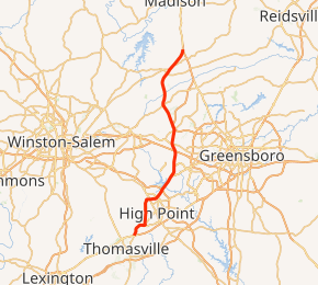
Route of NC 68 in red | ||||
| Route information | ||||
| Maintained by NCDOT | ||||
| Length | 30.8 mi[1] (49.6 km) | |||
| Existed | 1930–present | |||
| Major junctions | ||||
| South end | ||||
| ||||
| North end | ||||
| Location | ||||
| Counties | Davidson, Guilford, Rockingham | |||
| Highway system | ||||
| ||||

Route description
Beginning in the south at Business I-85/US 29/US 70, the route travels north out of Thomasville in Davidson County as National Highway, a name which referred to the former routing of US 29/70 (later US 29A/70A) along this segment. Crossing from Davidson County into neighboring Guilford County and the city of High Point, NC 68 is cosigned with English Road. Approximately one mile (1.6 km) within the city limits, NC 68 turns left onto Westchester Drive, a boulevard that bypasses High Point's downtown area. Arriving at the Main Street interchange, NC 68 continues onto Eastchester Drive, another boulevard. After passing Oak Hollow Mall, I-74 (High Point East Belt), and the Wendover Avenue interchange, NC 68 and Eastchester Drive continue north into neighboring Greensboro.[1][2]
Shortly after entering Greensboro, NC 68 meets Interstate 40/US 421, and becomes a limited access freeway after a traffic signal at Triad Center Drive. Continuing north as a divided four-lane highway, NC 68 has junctions with W. Market Street (Colfax exit) and I-73, the exit for Piedmont Triad International Airport. The road downgrades to an undivided primary road at the Pleasant Ridge Road junction. From there, the route heads north through the heart of Oak Ridge, North Carolina, passing the Oak Ridge Military Academy at the route's intersection with NC 150. After crossing the Haw River into Stokesdale, NC 68 crosses US 158 and joins NC 65 for a short 1-mile (1.6 km) concurrency, before splitting to the northeast en route to its northern terminus at US 220 in Rockingham County.[1][2] This interchange doubles as the current northern terminus of I-73 though no direct access is provided between I-73 and NC 68.[1]
History
The first NC 68 was an original state highway that traversed from NC 60, in Millers Creek (west of Wilkesboro), northwest through Glendale Springs, Jefferson and Crumpler, before crossing into Virginia.[3] By 1928, NC 68 was rerouted west of Jefferson onto new primary routing west to the Tennessee state line; the old alignment becoming NC 681.[4] In 1929, all of NC 68 was replaced by an extension of NC 16.[4][5]
The second and current NC 68 was established in 1930 as a new primary routing from US 70/US 170/NC 10, northeast of High Point, to NC 65, in Stokesdale.[5][6] In 1936, NC 68 was rerouted south through High Point to US 29A/US 70A (Lexington Avenue); its old alignment, along Penny Road, became a secondary road.[7][8] In 1941, NC 68 was extended north on new primary routing to US 220 (Sylvania Road).[9][10]
In 1952, NC 68 was extended north to its current terminus with US 220, replacing part of old US 220.[11][12] Between 1950-1953, NC 68 was extended south to English Street.[13][14] In 1956 or 1957, NC 68 was extended to its current southern terminus, sharing a concurrency with US 29A/US 70A, until 1991.[15] In 1982, NC 68 was placed on new freeway connecting I-40 and the Piedmont Triad International Airport, its old alignment along Bull Road (today's Regional Road) a secondary road.[16]
Future
Future NCDOT plans call for the construction of a new four-lane highway connecting NC 68 and US 220. Starting with a new interchange with I-73 (near Pleasant Ridge Road), improvements will be made along a short section of existing NC 68 before going northwest onto new construction that will bypass east of Oak Ridge and connect with US 220 in Summerfield. This section will become part of I-73.[17] North of Oak Ridge, safety improvements are to be done between East Harrell Road (SR 2111) and Bartonshire Drive (SR 4831). The estimated cost is $1.96 million. Property acquisition is expected to start in December 2014.[18][19]
Major intersections
| County | Location | mi[1] | km | Destinations | Notes |
|---|---|---|---|---|---|
| Davidson | Thomasville | 0.0– 0.2 | 0.0– 0.32 | Southern terminus; interchange | |
| Guilford | High Point | 9.0– 9.1 | 14.5– 14.6 | I-74 exit 67 | |
| Greensboro | 14.9– 15.1 | 24.0– 24.3 | To Piedmont Triad Farmers Market; I-40 exit 210 | ||
| 16.1– 16.4 | 25.9– 26.4 | Market Street – Colfax | Interchange | ||
| 16.7– 17.3 | 26.9– 27.8 | Cornerstone Drive | Interchange | ||
| 17.5– 17.9 | 28.2– 28.8 | I-73 exit 110; exit from I-73 to NC 68 southbound and entrance to I-73 northbound from NC 68 northbound only | |||
| 18.7– 19.0 | 30.1– 30.6 | I-73 exit 111 | |||
| Oak Ridge | 21.9 | 35.2 | |||
| Stokesdale | 26.6 | 42.8 | |||
| 27.3 | 43.9 | West end of NC 65 overlap | |||
| 28.0 | 45.1 | East end of NC 65 overlap | |||
| Rockingham | | 30.8 | 49.6 | Northern terminus; interchange; northern terminus of I-73, no access to I-73/US 220 southbound / from I-73/US 220 northbound; Continuation as US 220 North | |
1.000 mi = 1.609 km; 1.000 km = 0.621 mi
| |||||
References
- Google (May 1, 2019). "North Carolina Highway 68" (Map). Google Maps. Google. Retrieved May 1, 2019.
- State Transportation Map (Map) (2013–14 ed.). Cartography by North Carolina State Tax Commission. North Carolina Department of Transportation. 2013.
- The State Highway System of North Carolina (Map) (1924 ed.). Cartography by North Carolina State Tax Commission. North Carolina State Highway Commission. 1924.
- The State Highway System of North Carolina (Map) (1928 ed.). Cartography by North Carolina State Tax Commission. North Carolina State Highway Commission. 1928.
- The State Highway System of North Carolina (Map) (1929 ed.). Cartography by North Carolina State Tax Commission. North Carolina State Highway Commission. 1929.
- The State Highway System of North Carolina (Map) (1930 ed.). Cartography by North Carolina State Tax Commission. North Carolina State Highway Commission. 1930.
- The State Highway System of North Carolina (Map) (1935 ed.). Cartography by North Carolina State Tax Commission. North Carolina State Highway Commission. 1935.
- The State Highway System of North Carolina (Map) (1936 ed.). Cartography by North Carolina State Tax Commission. North Carolina State Highway Commission. 1936.
- The State Highway System of North Carolina (Map) (1940 ed.). Cartography by North Carolina State Tax Commission. North Carolina State Highway Commission. 1940.
- The State Highway System of North Carolina (Map) (1941 ed.). Cartography by North Carolina State Tax Commission. North Carolina State Highway Commission. 1941.
- North Carolina Primary Highway System (Map) (1951 ed.). Cartography by North Carolina State Tax Commission. North Carolina State Highway Commission. 1951.
- North Carolina Primary Highway System (Map) (1952 ed.). Cartography by North Carolina State Tax Commission. North Carolina State Highway Commission. 1952.
- North Carolina Primary Highway System (Map) (1950 ed.). Cartography by North Carolina State Tax Commission. North Carolina State Highway Commission. 1950.
- North Carolina Primary Highway System (Map) (1953 ed.). Cartography by North Carolina State Tax Commission. North Carolina State Highway Commission. 1953.
- "US Route Changes (1991-07-16)" (PDF). North Carolina Department of Transportation. July 16, 1991. Retrieved March 23, 2014.
- "NC Route Changes (1982-03-01)" (PDF). North Carolina Department of Transportation. March 1, 1982. p. 4. Retrieved March 23, 2014.
- Project #I-5110 / I-73 Connector (PDF) (Map). North Carolina Department of Transportation. Retrieved October 26, 2013.
- "NCDOT: NC 68 Improvements". Retrieved November 24, 2011.
- "NCDOT: NC 68 Preferred Project Alternative Map" (PDF). Retrieved November 24, 2011.
External links

- NCRoads.com: N.C. 68