Greensboro Urban Loop
The Greensboro Urban Loop is a partially completed 43.1-mile (69.4 km) beltway around Greensboro, North Carolina, United States. The loop carries Interstate 73 (I-73), I-85, I-785, I-840, and U.S. Route 421 (US 421). It is primarily located within Greensboro city limits, though it crisscrosses the city line many times. The right-of-way of the Urban Loop and its interchanges between Elm-Eugene Street and Huffine Mill Road was annexed by the city of Greensboro in 2005. As of December 2019, 33.7 miles (54.2 km) of the loop is open, with 5.86 miles (9.43 km) under construction between Lawndale Drive and US 29.
| |
|---|---|

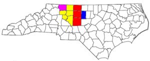
Completed section highlighted in red Section under construction highlighted in dark blue | |
| Route information | |
| Maintained by NCDOT | |
| Length | 43.1 mi[1] (69.4 km) |
| Existed | 2002–present |
| Component highways | |
| Major junctions | |
| Beltway around Greensboro | |
| From | |
| To | Lawndale Drive in Greensboro |
| Location | |
| Counties | Guilford |
| Highway system | |


Route description
The current terminus of the route is an interchange with US 29, from which the Urban Loop heads southeast as I-785/Future I-840. Turning south at an interchange with Huffine Mill Road, the road intersects US 70 shortly after. 2.2 miles (3.5 km) later, the Urban Loop comes to an interchange with I-40, I-85, and Business 85, at which point I-785 and Future I-840 both end and I-85 enters the Urban Loop as it heads southwest.
The road winds its way southwest as I-85, intersecting Youngs Mill Road and Alamance Church Road before joining with US 421 and turning west. After meeting Elm-Eugene Street, the Urban Loop comes to an interchange complex with I-73/US 220 and Business 85/US 29/US 70. Here, I-73 joins the Urban Loop from the south as I-85 leaves it to the southwest. The two interstates officially share a wrong-way concurrency for approximately 1 mile (1.6 km), though the collector-distributor roads of the interchanges cause the two routes to not share the same roadbed in either direction.
Winding its way northwest, the Urban Loop intersects Gate City Boulevard with a diverging diamond interchange and Wendover Avenue with a partial cloverleaf interchange before reaching another interchange with I-40. US 421 leaves the Urban Loop as I-840 begins, and the road continues due north as I-73/I-840. After a single-point urban interchange with Friendly Avenue, the road curves north-northeast before coming to an interchange with Bryan Boulevard. Here, I-73 leaves the Urban Loop to the west, and the road continues as I-840, running northeast and east for 4.82 miles (7.76 km). The loop intersects US 220 before terminating at Lawndale Drive.
A 5.86-mile (9.43 km) section currently under construction runs between Lawndale Drive and US 29, intersecting North Elm Street and Yanceyville Street.[2]
History
Early development
A June 1948 document from the city Planning & Zoning Commission described the loop as part of "a comprehensive thoroughfare system for Greensboro." At one time, the road was a parkway similar to Wendover Avenue and named Painter Boulevard, but the city did not have enough money to build it, and federal help would require a road like an Interstate Highway.[3] It was named for Pennell Churchman Painter, the first city manager of Greensboro, serving from 1921 to 1929.[4]
Painter Boulevard appeared as a freeway loop in the 1967 City of Greensboro Transportation Plan. In June 1977, a thoroughfare plan (including what would become the Urban Loop) was adopted by the City of Greensboro, Guilford County and the North Carolina Board of Transportation. In July 1989, North Carolina Highway Trust Fund Law was enacted, which provides a trust fund for designated urban loops. By November 1989, an updated thoroughfare plan was approved by the city, county and state. Planning and environmental impact studies of the Urban Loop began in 1989-1990. In 1995, a Record of Decision was made approving the Greensboro Urban Loop; finalizing its routing and approval of a I-85 bypass. By this point, the Painter Boulevard name was no longer used.
Initial construction
In 2002, the first segment of the urban loop opened, a 2.21-mile (3.56 km) four-lane connector, today a part of I-785/Future I-840, between I-40/I-85 and US 70; it was unsigned and internally designated SR 3269. By 2006, Future I-840 trailblazers were added, though from I-40/I-85 it was only signed "To US 70." On February 21, 2004, the 12.9-mile (20.8 km) southeast segment of the urban loop opened. On completion, I-85 was rerouted onto it, leaving its old alignment through Greensboro as Business 85.[5] The southwest section between the present day I-73/US 220 interchange and the I-73/Bryan Boulevard interchanges opened in March 2008. I-73 was signed south of I-40, though north of I-40, I-73 and I-840 were unsigned. At the time, signs for each direction simply read "To I-40" and "To Bryan Boulevard."
Interstate 40 relocation

Upon completion of the southwest section, I-40 was rerouted onto the southern portion of the loop, sharing the route with I-73 to the west and I-85 to the east. The existing I-40 through Greensboro was redesignated Interstate 40 Business (Business 40). On September 12, 2008, after complaints by local residents about traffic noise and motorists on the confusion between I-40 and Business 40 through Greensboro, NCDOT officials received permission from the Federal Highway Administration (FHWA) to reroute I-40 back through the city of Greensboro and decommission Business 40. This left I-40 on its original route, while US 421 was rerouted onto the Urban Loop where it remains today.
Later construction
On July 31, 2013, NCDOT got approval from the FHWA to co-sign the eastern section of the Urban Loop (Future I-840) with I-785, establishing the new route in North Carolina,[6] though I-785 would not be signed until the completion of the segment of the loop between US 29 and US 70.
The next section to go to construction was part of the northwest section between I-73/Bryan Boulevard and US 220 (Battleground Avenue) in October 2013.[7] Next was the northeast section from US 29 to US 70 in 2014.[8] In October 2017, ahead of the completion of the northwest section and as a new section of I-73 opened,[9] both I-73 and I-840 were signed on the portion of the Urban Loop between I-40 and Bryan Boulevard, marking the first time I-840 was signed as a proper route.
The northeast section was completed in December 2017,[8] signed solely as I-785, at which point the designation was also signed on the eastern section of the loop between US 70 and I-40/I-85. The northwest section opened in March 2018, extending I-840 to US 220.[7] The next section, between US 220 and Lawndale Drive, opened on December 30, 2019.[10][11]
Future
The last section of the Greensboro Urban Loop under construction is the 5.86-mile (9.43 km) segment between Lawndale Drive and US 29, featuring interchanges with North Elm Street and Yanceyville Street.[2] Construction began in May 2018[12] and will be opened in two sections. The first, from Lawndale Drive to North Elm Street, is expected to open by the end of 2020, with the last segment to US 29 opening in 2021 or 2022.[10][11] Upon completion of this last segment, I-840 will be posted along its entire length, including the concurrency with I-785.
After the Greensboro Urban Loop is completed, NCDOT and Greensboro DOT plan to add two additional interchanges: Fleming–Lewiston Road (SR 2136), and Cone Boulevard (SR 2565). Plans for these additional interchanges have existed since 2004; however, because they are to be constructed after the loop's completion, there is no current time table or funding for these projects at this time.[13][14][15]
Exit list
The entire route is in Guilford County.
| Location | mi[1] | km | Exit | Destinations | Notes |
|---|---|---|---|---|---|
| Greensboro | 0.0 | 0.0 | 103 A–B | A: B: | Western terminus of I-840 and northern terminus of US 421 overlap; left exit from inner loop |
| 1.6 | 2.6 | 104 | West Friendly Avenue | Single-point urban interchange | |
| | 3.6 | 5.8 | 107 3 | A: Bryan Boulevard – Downtown B: | Northern terminus of I-73 overlap; inner loop exit signed as I-73 exits 107 A–B; outer loop exit signed as I-840 exits 3B-A |
| Greensboro | 6.7 | 10.8 | 6 | Single-point urban interchange | |
| 8.4 | 13.5 | 8 | Lawndale Drive | Single-point urban interchange; temporary terminus of Greensboro Urban Loop | |
| 10.4 | 16.7 | 10 | North Elm Street | Future interchange[13] | |
| 11.8 | 19.0 | 11 | Yanceyville Street | Future interchange[13] | |
| | 14.3 | 23.0 | 14A–B | A: B: | Temporary terminus of Greensboro Urban Loop; current northern terminus of I-785 and western terminus of hidden I-840 overlap |
| 17.8 | 28.6 | 17 | Huffine Mill Road | ||
| Greensboro | 18.9 | 30.4 | 18 | ||
| 21.1 | 34.0 | 21 | North end of I-85 overlap, south end of I-785 and east end of hidden I-840 | ||
| 23.1 | 37.2 | 129 | Youngs Mill Road | ||
| 25.2 | 40.6 | 128 | Alamance Church Road | ||
| 27.3 | 43.9 | 126 A–B | A: B: Old US 421 – Greensboro | South end of US 421 overlap | |
| 29.6 | 47.6 | 124 | South Elm–Eugene Street | ||
| | 31.6 | 50.9 | 122 A–C | A: To Groometown Road / To Grandover Parkway B / 95: C: | Southern terminus of I-73 concurrency; signed as exit 122 from inner loop and exit 95 from outer loop; no access from US 220 southbound to inner loop nor from outer loop to US 220 northbound; exit 122A only accessible from inner loop |
| 32.9 | 52.9 | 97 A–C | A: B: C: To Groometown Road / To Grandover Parkway | South end of I-85 overlap; exit 97 signed from southbound I-73; unnumbered from southbound I-85; exit 97C only accessible from outer loop; no access from inner loop to Business 85 nor from Business 85 to outer loop | |
| 35.8 | 57.6 | 100 | Gate City Boulevard | Diverging diamond interchange | |
| 38.4 | 61.8 | 102 | Wendover Avenue | ||
| Greensboro | 0.0 | 0.0 | 103 A–B | A: B: | West end of I-840 and northern end of US 421 overlap; northbound exit left |
1.000 mi = 1.609 km; 1.000 km = 0.621 mi
| |||||
References
- Google (August 29, 2013). "Greensboro Urban Loop" (Map). Google Maps. Google. Retrieved August 29, 2013.
- North Carolina Department of Transportation. Greensboro Urban Loop and Interchanges (PDF) (Map). North Carolina Department of Transportation. Retrieved December 31, 2019.
- Wireback, Taft (July 23, 2017). "70 years of road planning in Greensboro takes concrete shape". News & Record. Retrieved July 23, 2017.
- "This day in history". News & Record. December 15, 2015. Retrieved March 30, 2017.
- Special Committee on U.S. Route Numbering (May 15, 2004). "Report of the Special Committee on U.S. Route Numbering to the Standing Committee on Highways" (PDF) (Report). Washington, DC: American Association of State Highway and Transportation Officials. p. 5. Archived (PDF) from the original on October 16, 2017. Retrieved November 24, 2014.
- "I-785 Route Change (2013-07-31)" (PDF). North Carolina Department of Transportation. July 31, 2013. Retrieved August 28, 2013.
- https://www.ncdot.gov/projects/greensboro-urban-loop/western-loop/Pages/default.aspx
- https://www.ncdot.gov/projects/greensboro-urban-loop/eastern-loopb/Pages/default.aspx
- https://www.ncdot.gov/projects/i-73-greensboro/Pages/default.aspx
- "New section of Greensboro Urban Loop opens". High Point, NC: WGHP. December 30, 2019. Retrieved December 31, 2019.
- Wireback, Taft (December 30, 2019). "New section of the Greensboro Urban Loop opens. It's expected to reduce 'cut-through' traffic that has plagued area neighborhoods". Greensboro, North Carolina: News & Record. Retrieved December 31, 2019.
- Wireback, Taft (May 27, 2018). "Greensboro Urban Loop's last section is in the works". Greensboro, North Carolina: News & Record. Retrieved December 31, 2019.
- "NCDOT: Greensboro Urban Loop". North Carolina Department of Transportation. Retrieved December 31, 2019.
- "Fleming Road Extension/Western Urban Loop Interchange" (PDF). Greensboro DOT & North Carolina DOT. December 16, 2004. Retrieved August 31, 2013.
- "Cone Boulevard Extension/Eastern Urban Loop Interchange" (PDF). Greensboro DOT & North Carolina DOT. August 17, 2004. Retrieved August 31, 2013.
External links

- Greensboro Urban Loop | AARoads Interstate Guide
- Map of the Greensboro Urban Loop and Interchanges
- Greensboro Urban Area Bicycle, Pedestrian & Greenway Master Plan (October, 2006)
- NCDOT Urban Loop Project (September 19, 2012)