Troisdorf
Troisdorf (German pronunciation: [ˈtʁoːsdɔɐ̯f] is a town in the Rhein-Sieg-Kreis (district), in North Rhine-Westphalia, Germany.
Troisdorf | |
|---|---|
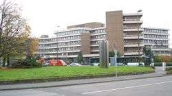 Town hall of Troisdorf | |
 Coat of arms | |
Location of Troisdorf within Rhein-Sieg-Kreis district 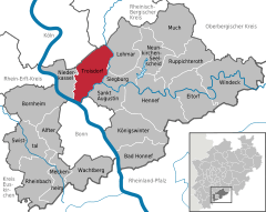  | |
 Troisdorf 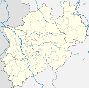 Troisdorf | |
| Coordinates: 50°48′58″N 07°09′20″E | |
| Country | Germany |
| State | North Rhine-Westphalia |
| Admin. region | Köln |
| District | Rhein-Sieg-Kreis |
| Subdivisions | 12 |
| Government | |
| • Mayor | Klaus-Werner Jablonski (since October 2009) (CDU) |
| Area | |
| • Total | 62.17 km2 (24.00 sq mi) |
| Elevation | 55 m (180 ft) |
| Population (2018-12-31)[1] | |
| • Total | 74,903 |
| • Density | 1,200/km2 (3,100/sq mi) |
| Time zone | CET/CEST (UTC+1/+2) |
| Postal codes | 53840, 53842, 53844 |
| Dialling codes | 02241, 02203, 02246, 0228 |
| Vehicle registration | SU |
| Website | www.troisdorf.de |
Geography
Troisdorf is located approximately 22 kilometers south of Cologne and 13 kilometers north east of Bonn.[2]
Division of the town
Troisdorf consists of 12 districts (population as of April, 2014):[2]
- Troisdorf-Mitte (16,414 inhabitants)
- Altenrath (2,292 inhabitants)
- Bergheim (5,750 inhabitants)
- Eschmar (3,078 inhabitants)
- Friedrich-Wilhelms-Hütte (7,161 inhabitants)
- Kriegsdorf (3,129 inhabitants)
- Müllekoven (1,793 inhabitants)
- Oberlar (6,100 inhabitants)
- Rotter See (3,918 inhabitants)
- Sieglar (8,668 inhabitants)
- Spich (12,765 inhabitants)
- West (5,367 inhabitants)
- (total 76,435 inhabitants)
History
Troisdorf became a free city in 1952. In 1969, the urban area expanded with the annexation of the township of Sieglar and the villages of Altenrath and Friedrich-Wilhelms-Hütte (total population in 1969: about 51,000). The first large settlements in this area go back to the 9th and 10th century (Eschmar and Sieglar 832, Bergheim 987). The first churches in this area were built around 700 AD in Bergheim (St. Lambertus).
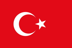
Troisdorf is home to about 9600 foreign nationals. The two most numerous foreign national groups are Turks (3100) and Greeks (1600). On June 4, 1972, Troisdorf founded the first advisory council for foreign citizens in Germany. In the years following the Peaceful Revolution and German reunification of 1989/1990 many migrants from Russia and other East European countries settled in Troisdorf.
Demographics
On April, 2014, Troisdorf had a population of 76,435 according to official records.[2] 11% of the population are foreign migrants.
Troisdorf has a predominantly Christian population: Roman Catholics, Protestants, Baptists, Jehovah's Witnesses and other Christian denominations, along with Muslim, Orthodox Christian and Jewish populations of non-indigenous origin. Troisdorf is one of the German cities where its mosque includes a minaret, built for the local Islamic community.
Mayors
volunteers:
- 1969–1975: Josef Ludwig (CDU)
- 1975–1993: Hans Jaax (SPD)
- 1993–1998: Uwe Göllner (SPD)
- 1998–1999: Walter Bieber (SPD)
professionals:
- 1999–2009: Manfred Uedelhoven (CDU)
- since October 21, 2009: Klaus-Werner Jablonski (CDU)
Notable places
Europe's only picture-book museum is located in Troisdorf at the Burg Wissem castle.
Twin towns - sister cities
Troisdorf is twinned with:[3]

.svg.png)


Notable persons
- John Siberch, pioneering printer and friend of Erasmus
- Tom Buhrow, German news anchor
- Lena Schöneborn, Olympic champion in Modern Pentathlon 2008
- Sabine Lisicki, German professional tennis player
- Rupert Neudeck, founder of the Cap Anamur, a German humanitarian aid organisation
- Paul Schäfer, founder Colonia Dignidad, a German sect in Chile
- Walter Stern, art critic and broadcaster
- Mitchell Weiser, association football player
References
- "Bevölkerung der Gemeinden Nordrhein-Westfalens am 31. Dezember 2018" (in German). Landesbetrieb Information und Technik NRW. Retrieved 10 July 2019.
- "Willkommen in Troisdorf / Zahlen – Daten – Fakten" (PDF) (in German). Town of Troisdorf. p. 3. Retrieved 25 March 2015.
- "Partner- und Patenstädte". troisdorf.de (in German). Troisdorf. Retrieved 2019-11-23.
External links
- Official website (in English)
- Official website (in German)
Towns and municipalities in Rhein-Sieg-Kreis | ||
|---|---|---|
| Authority control |
|
|---|