Rhein-Sieg-Kreis
The Rhein-Sieg-Kreis is a Kreis (district) in the south of North Rhine-Westphalia, Germany. Neighboring districts are Rheinisch-Bergischer Kreis, Oberbergischer Kreis, Altenkirchen, Neuwied, Ahrweiler, Euskirchen, Rhein-Erft-Kreis, the urban district of Cologne. The federal city of Bonn is nearly completely surrounded by the district.
Rhein-Sieg-Kreis | |
|---|---|

| |
| Country | Germany |
| State | North Rhine-Westphalia |
| Adm. region | Cologne |
| Capital | Siegburg |
| Area | |
| • Total | 1,153.51 km2 (445.37 sq mi) |
| Population (31 December 2018)[1] | |
| • Total | 599,780 |
| • Density | 520/km2 (1,300/sq mi) |
| Time zone | UTC+01:00 (CET) |
| • Summer (DST) | UTC+02:00 (CEST) |
| Vehicle registration | SU |
| Website | http://www.rhein-sieg-kreis.de |
History
The district as known today was created in 1969, during the reorganization of the districts in North Rhine-Westphalia, by merging Sieg District with the District of Bonn (from which Bonn itself was separated in 1887 to become an urban district). Sieg District was created in 1825.
Geography
Geographically Rhein-Sieg District covers the valley of the river Sieg and also, since the merger with the District of Bonn, that of the Rhine around Bonn, as well an area in the most easterly part of the Eifel.
Coat of arms
 |
The red lion is the symbol of the dukes of Berg, who owned a large part of the district. The black cross in the shield is the symbol of Cologne, because another part of the district was owned by the bishops of Cologne. The yellow sword is the symbol of Saint Michael, the patron of the mighty Michaelsberg Abbey in Siegburg. |
Demographics
Number of 1st and 2nd generation foreigners in Rhein-Sieg-Kreis by top 10 country of origin per 31 December 2007[2]
| Rank | Ancestry | Number |
|---|---|---|
| 1 | 13,255 | |
| 2 | 3,982 | |
| 3 | 3,024 | |
| 4 | 2,825 | |
| 5 | 1,353 | |
| 6 | 1,284 | |
| 7 | 1,272 | |
| 8 | 1,244 | |
| 9 | 1,203 | |
| 10 | 994 |
Towns and municipalities
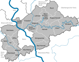
| Towns | Municipalities |
|---|---|
References
- "Bevölkerung der Gemeinden Nordrhein-Westfalens am 31. Dezember 2018" (in German). Landesbetrieb Information und Technik NRW. Retrieved 10 July 2019.
- "Ausländer_2006-2007_Kreise.xls" (PDF). Retrieved 2013-03-12.
External links
| Wikimedia Commons has media related to Rhein-Sieg-Kreis. |
- Official Website (German, English, French)
