Rheinbach
Rheinbach is a town in the Rhein-Sieg-Kreis district (Landkreis), in North Rhine-Westphalia, Germany. It belongs to the administrative district (Regierungsbezirk) of Cologne.
Rheinbach | |
|---|---|
 Aerial view of Rheinbach | |
 Coat of arms | |
Location of Rheinbach within Rhein-Sieg-Kreis district   | |
 Rheinbach 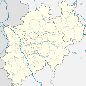 Rheinbach | |
| Coordinates: 50°38′N 6°57′E | |
| Country | Germany |
| State | North Rhine-Westphalia |
| Admin. region | Cologne |
| District | Rhein-Sieg-Kreis |
| Subdivisions | 9 |
| Government | |
| • Mayor | CDU |
| Area | |
| • Total | 69.74 km2 (26.93 sq mi) |
| Elevation | 173 m (568 ft) |
| Population (2018-12-31)[1] | |
| • Total | 27,063 |
| • Density | 390/km2 (1,000/sq mi) |
| Time zone | CET/CEST (UTC+1/+2) |
| Postal codes | 53359 |
| Dialling codes | 02226 |
| Vehicle registration | SU |
| Website | www.rheinbach.de |
Geography
Situated 15 km (9 mi) south-west of Bonn and 35 km (22 mi) south of Cologne, Rheinbach lies at the edge of the Eifel region and within the borders of Rhineland's nature reserve.
History
Around 80 AD, the Eifel Aqueduct, one of the longest aqueducts of the Roman Empire, was running through what is today Rheinbach's town centre.[2] The first written documentation of Rheinbach dates back to 762, when Pepin the Short, then King of the Franks, gave lands to the Prüm Abbey.[3] In the Middle Ages, Rheinbach came to prominence because of its witch-hunts.

First referred to as a town in 1298, the Archbishop of Cologne purchased Rheinbach and the surrounding villages in 1343. Till 1789, Rheinbach was part of the Electorate of Cologne. In 1794, Rheinbach was incorporated into France within the Département de Rhin-et-Moselle before coming under the auspices of Prussia in 1815.
Around 1947, a considerable number of displaced people from the Sudetenland settled in Rheinbach. Having brought their traditions of glasscraft, Rheinbach became famous for its glass art and today hosts a glass art museum and a specialized school.
Coat of arms
The coat of arms was made official in 1915 by Wilhelm II, German Emperor and King of Prussia. The black cross with the silver background stands for the archdiocese of Cologne. The Eagle stems from the coat of arms from the Counts of Are-Hochstaden. The blue key refers to the Holy Saint Peter, the patron saint of the Archdiocese of Cologne.[4]
Governance

Besides the town proper, Rheinbach administratively comprises the surrounding villages and hamlets, including Flerzheim.
As of 2016, the town council has a Christian Democratic (CDU) majority with 17 seats; the Social Democrats (SPD) hold 10 seats, while the Greens (Die Grünen), the Independents (UWG) and the Liberals (FDP) hold three each.
Infrastructure
Education
A local hub for education, Rheinbach is the seat of the Hochschule Bonn-Rhein-Sieg, a university of applied science which specializes in business and biomedical sciences.
There are three secondary schools in Rheinbach. The municipal Gymnasium was founded in 1852 and is one of the oldest public secondary schools in the Bonn region; the Vinzenz-Pallotti-Kolleg is one of the few boarding and private schools in Germany; the Catholic run St.-Joseph-Gymnasium was historically a girls-only school and is now coeducational.
Transport
Rheinbach lies in proximity to the Bundesautobahn 61 which connects it with Cologne. The S-Bahn RB23 connects Rheinbach with Bad Münstereifel and Bonn. Rheinbach is part of the regional bus network of Cologne (Regionalverkehr Köln).
Twin towns - sister cities
Rheinbach is twinned with:[5]
.svg.png)


Rheinbach and the similarly named town of Rhinebeck, New York, USA, participate in a student exchange program.[6]
Notable people
- Pius Heinz, winner of the Main Event of 2011 World Series of Poker
- Peter Lavies, Wisconsin tavernkeeper, postmaster, moneylender and legislator
- Tim Lobinger, pole vaulter
- Michael Preisinger, writer
- Markus Pröll, footballer
- Norbert Röttgen, German politician and former federal minister under Angela Merkel
References
- "Bevölkerung der Gemeinden Nordrhein-Westfalens am 31. Dezember 2018" (in German). Landesbetrieb Information und Technik NRW. Retrieved 10 July 2019.
- Klaus Grewe: Aquädukte. Wasser für Roms Städte. Der große Überblick – vom Römerkanal zum Aquäduktmarmor. Regionalia Verlag, Rheinbach 2014, ISBN 978-3-95540-127-6, p. 295.
- Heinrich Beyer: Urkundenbuch zur Geschichte der, jetzt die Preussischen Regierungsbezirke Coblenz und Trier bildenden mittelrheinischen Territorien. Aus den Quellen herausgegeben von Heinrich Beyer. Erster Band: Von den ältesten Zeiten bis zum Jahre 1169. Hölscher, Coblenz 1860, S. 20.
- civitec, Zweckverband (2015-12-14). "Stadtwappen". rheinbach.de (in German). Retrieved 2017-04-14.
- "Partnerschaftsstädte". rheinbach.de (in German). Rheinbach. Retrieved 2019-11-28.
- http://rhinebeckexchange.org/
External links
- Official site (in German)
- University of Applied Sciences Bonn-Rhein-Sieg (in German)
Towns and municipalities in Rhein-Sieg-Kreis | ||
|---|---|---|
| Authority control |
|
|---|