Ruppichteroth
Ruppichteroth is a municipality in the Rhein-Sieg district, in the southern part of North Rhine-Westphalia, Germany. It is located approximately 30 kilometers east of Bonn.
Ruppichteroth | |
|---|---|
 Coat of arms | |
Location of Ruppichteroth within Rhein-Sieg-Kreis district 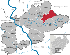  | |
 Ruppichteroth 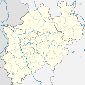 Ruppichteroth | |
| Coordinates: 50°50′38″N 7°29′01″E | |
| Country | Germany |
| State | North Rhine-Westphalia |
| Admin. region | Köln |
| District | Rhein-Sieg-Kreis |
| Subdivisions | 3 |
| Government | |
| • Mayor | Mario Loskill |
| Area | |
| • Total | 61.95 km2 (23.92 sq mi) |
| Highest elevation | 361 m (1,184 ft) |
| Lowest elevation | 80 m (260 ft) |
| Population (2018-12-31)[1] | |
| • Total | 10,408 |
| • Density | 170/km2 (440/sq mi) |
| Time zone | CET/CEST (UTC+1/+2) |
| Postal codes | 53809 |
| Dialling codes | 02295, 02247 |
| Vehicle registration | SU |
| Website | www.ruppichteroth.de |
Districts
In 1969, the old municipality of Winterscheid became part of Ruppichteroth. Since then the municipality consists of three districts:
- Ruppichteroth
- Schönenberg
- Winterscheid
History
Ruppichteroth was first mentioned in 843.
Twin towns
References
- "Bevölkerung der Gemeinden Nordrhein-Westfalens am 31. Dezember 2018" (in German). Landesbetrieb Information und Technik NRW. Retrieved 10 July 2019.
External links
- Official site (in German)
Towns and municipalities in Rhein-Sieg-Kreis | ||
|---|---|---|
| Authority control |
|
|---|
This article is issued from Wikipedia. The text is licensed under Creative Commons - Attribution - Sharealike. Additional terms may apply for the media files.