Lalgudi taluk
Lalgudi taluk is an administrative area of Tiruchirapalli district of the Indian state of Tamil Nadu. The headquarters of the taluk is the town of Lalgudi. The taluk of Lalgudi was formed 100 years ago by the British East India Company. Lalgudi taluk consists of two revenue blocks named Pullambadi block and Lalgudi block.
Lalgudi | |
|---|---|
| Coordinates: 10.87°N 78.83°E | |
| country | |
| state | Tamil Nadu |
| Region | Chola Nadu |
| zone | cental |
| District | Tiruchirappalli district |
| division | Lalgudi |
| language | |
| • Official | Tamil |
| Time zone | UTC+5.30 |
| PIN | 621 601 |
| Telephone code | 0431 |
| Vehicle registration | TN-48 |
Transport
The taluk is well connected by roadways as well as railways. NH227 runs longitudinally across the taluk. Government and private buses connect the villages with taluk and district headquarters, and the major towns and cities of central Tamil Nadu. Lalgudi, Pullambadi, Dalmiapuram and Valadi are the major railway stations. The nearest airport is the Tiruchirapalli International Airport.
Urban areas
Number of revenue villages
The taluk hosts 78 villages. 45 are under the revenue block of Lalgudi. The remaining 33 villages are under the revenue block of Pullambadi.
Rivers
Kollidam, Peruvalai, Iyan, Panguni, and Pullambadi are the important channels which traverse the taluk.
Demographics
According to the 2011 census, Lalgudi had a population of 254,705 with 124,855 males and 129,850 females. There were 1040 women for every 1000 men. The taluk had a literacy rate of 75.56%. The under-6 age group held 11,821 Males and 11,296 Females.[1]
References
- "Provisional Population Totals – Tamil Nadu-Census 2011" (PDF). Census Tamil Nadu. Archived from the original (PDF) on 17 June 2013. Retrieved 4 July 2013.
| District headquarters | 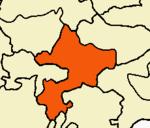 | ||||||
|---|---|---|---|---|---|---|---|
| Country | |||||||
| State | |||||||
| Region | |||||||
| Divisions | |||||||
| Taluks | |||||||
| Revenue blocks | |||||||
| Municipal corporations | |||||||
| Municipalities | |||||||
| Rivers | |||||||
| History |
| ||||||
| Places of interest |
| ||||||
| Educational institutions |
| ||||||
| |||||||