Salween River
The Salween, known in China as the Nu River, is a river about 2,815 kilometres (1,749 mi) long that flows from the Tibetan Plateau into the Andaman Sea in Southeast Asia.
| Salween Nu River | |
|---|---|
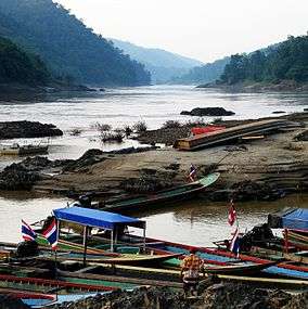 Salween River forming the boundary between Myanmar and Thailand | |
 Salween drainage area | |
| Native name | ᥑᥨᥒᥰ/ၶူင်း (nam Khoong) (Tai languages) |
| Location | |
| Country | China, Myanmar, Thailand |
| Provinces (PRC) | Tibet Autonomous Region, Yunnan |
| States (Myanmar) | Shan, Kayah, Kayin, Mon |
| Province (Thailand) | Mae Hong Son |
| Cities | Nagqu, Mawlamyaing |
| Physical characteristics | |
| Source | Tanggula Mountains |
| • location | Unknown glacier, Nagqu, Tibet, China |
| • coordinates | 32°43′15″N 92°13′33″E |
| • elevation | 5,350 m (17,550 ft) |
| Mouth | Andaman Sea |
• location | Mawlamyaing, Burma |
• coordinates | 16°11′39″N 97°35′00″E |
• elevation | 0 m (0 ft) |
| Length | 2,815 km (1,749 mi) |
| Basin size | 324,000 km2 (125,000 sq mi) |
| Discharge | |
| • average | 4,978 m3/s (175,800 cu ft/s)[1] |
| Basin features | |
| Tributaries | |
| • left | Moei River |
It drains a narrow and mountainous watershed of 324,000 square kilometres (125,000 sq mi) that extends into the countries of China, Burma and Thailand. Steep canyon walls line the swift and powerful Salween. Its extensive drainage basin supports a biodiversity comparable with the Mekong and is home to about 7 million people. In 2003, key parts of the mid-region watershed of the river were included within the Three Parallel Rivers of Yunnan Protected Areas, a UNESCO World Heritage Site.[2]
The people who live on the Salween are relatively isolated from the rest of the world. The river is only navigable up to 90 kilometres (56 mi) from the mouth, and only in the rainy season.
The Burma Road was constructed between 1937 and 1938 during the Second Sino-Japanese War and crossed the river at the Huitong bridge. The Huitong bridge was blown by the retreating Chinese army and the river became the frontline from 1942 to 1944. The Salween Campaign of World War II, was launched in order to liberate occupied China and open the Burma Road again and connect it to the Ledo Road.
Logging began on the mountains surrounding the Salween in the late 20th century, and has damaged the river's ecology. In recent years, there have been a number of proposals to dam the Salween River, both upstream in China and downstream in Myanmar, which have prompted social and environmental concerns as well as widespread opposition.[3][4] Construction of at least one upstream dam on a tributary of the Salween is currently underway in China's Yunnan province, with many more expected to follow.
Names
The Salween, officially Thanlwin River,[5] is a transcription of Burmese သံလွင်မြစ် (IPA: [θàɰ̃lwɪ̀ɰ̃ mjɪʔ]). Names of the river in other local languages include Thai: แม่น้ำสาละวิน, Phlone: ကၟံင့်ယှောတ်ခၠေါဟ်; S'gaw Karen: ဃိၣ်လီၤကျိ; and Mon: သာန်လာန် [san lon].
In China, the river is known as Nu River or Nujiang (Chinese: 怒江; pinyin: Nù Jiāng), after the Nu people living in the area.[6] Among the Tai people of Yunnan, it is Hong River (Tai Nuea language: ᥑᥨᥒᥰ xoong; Tai Long language: ၶူင်း xuung). The river's upper reaches in Tibet is known as Nagqu (Tibetan: ནག་ཆུ, Wylie: nag chu, ZYPY: Nagqu , "black river", Chinese: 那曲).
Geography
.jpg)
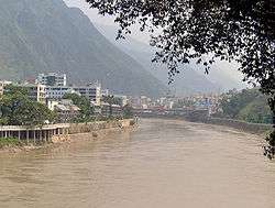
The Salween rises at 5,450 metres (17,880 ft)[7] in the Tanggula Mountains on the Tibetan Plateau, near the headwaters of the Mekong and Yangtze rivers.[8] It initially flows west but then very shortly makes a great bend to the east, entering the Chinese province of Yunnan and the Three Parallel Rivers of Yunnan Protected Area, a World Heritage Site. Here, the Salween—called the Nu or Nu Jiang[8]—has been proposed for a series of enormous dams that would theoretically generate more power than Three Gorges Dam, currently the world's largest hydroelectric station. It then makes a wide southward arc between the Tibetan and Yunnan-Guizhou Plateaus, dropping into what is often known as the "Grand Canyon of the East" or "China's Grand Canyon",[8] a 4,000-metre (13,000 ft)-deep gorge that takes it past the Chinese border into northeastern Burma through Shan State and Kayah State.[9]
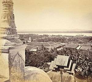
A sharp bend west and another south takes the Salween between the great mountain ranges of eastern Burma, the Daen Lao Range, a subrange of the Shan Hills, followed by the Dawna Hills in the east and the Karen Hills in the west,[10] the river then receives the Pai River also from the left and flows through Salawin National Park to join the Moei River from the east as it approaches Thailand, where it is called the Salawin, forming the Burma-Thailand boundary for about 120 kilometres (75 mi), before re-entering Burma, passing through Karen State and Mon State.[9] The river finally breaks out of its gorge about 250 kilometres (160 mi) from the mouth, and slows down dramatically as it courses through a series of agricultural valleys. About 89 kilometres (55 mi) from the mouth the river finally widens and deepens enough to become navigable for large watercraft. In quick succession it receives Dontham River from the right and Gyaing River from the left, from where the river turns west, flowing under Thanlwin Bridge and widening into a small river delta at Mawlamyaing (formerly Moulmein). This region is the most heavily developed on the river and contains most of the basin's population.
Near the mouth the river has an average annual discharge of 1,659 cubic metres per second (58,600 cu ft/s), although this varies widely. The river's base flow is provided by Tibetan glaciers, although it swells dramatically by the time it reaches the lowlands near the coast, especially in monsoon season.[11]
Basin
The Salween basin is one of the largest in Southeast Asia, encompassing approximately 324,000 square kilometres (125,000 sq mi), and spreading across three countries and four Burmese states. For much of its length, the Salween's course is nearly parallel to that of the much larger Mekong in the east.[8] Although the commonly accepted name is Salween, the river is known by a handful of other names regionally: Nu in China, Thanlwin in southern Burma, and Salawin on the border of Thailand and Burma.
Several major sub-continental drainage basins border on the Salween. The Mekong basin forms nearly the entire eastern boundary of the watershed, while the Irrawaddy River flows southwards on the west side of the basin. The smallest boundary is formed by the Yangtze to the extreme north. These three rivers bound nearly 80 percent of the Salween basin, but there are other smaller drainage areas to the southeast and southwest, some emptying into the Andaman Sea/Indian Ocean and some into the Gulf of Thailand.[12]
Geology
Much of the watershed consists of one canyon generally paralleling the crustal convergence of the Indian subcontinent and mainland Asia. When India collided with Asia approximately 50 million years ago, many geographical features in the region were forced upwards to great heights, forming such landmarks as the Himalayas, Qinghai Mountains, the Tibetan Plateau, and the eastern Burma massif.[13] To date, India's plate has pushed the boundary of the original Asian continent nearly 2,000 kilometres (1,200 mi) northwards. Evidence suggests that the southern Tibetan Plateau saw uplift as recently as 15-10 million years ago.[14] The orogenic belt generally trends east to west near the northern part of the Subcontinent and makes a southward arc along with the Salween River on the eastern side.[13] The upper course of the Salween flows through a region dominated by marine sedimentary rock that originally lay at the bottom of the Indian Ocean. This rock was uplifted to a height of thousands of metres by the India-Asia orogeny and is rapidly being eroded away by the Salween.[13] Fault lines are strewn throughout the Salween basin, also generally following the pattern of the mountains and river.
Natural history
One of the most diverse ecoregions in the world is supported by the Salween drainage basin.[8] The river and its valley supports about 140 species of fish, 7,000 species of plants, 10–15 genera of turtles, and 80 threatened species.[8] Many of the species are endemic to the Salween.[8] The Three Parallel Rivers of Yunnan Protected Areas in the upper third of the river's course alone has 6,000 plant species. The Salween, the upper basin especially, is so diverse that it has up to 25% of the world's animal species and 50% in China alone.[15][16] According to UNESCO, the upper regions of the Salween in China, where it runs parallel to the Mekong and Yangtze rivers, "may be the most biologically diverse temperate ecosystem in the world".
History
Indigenous people that lived on the river include Karen, Nu, Lisu, Shan, Karenni, Wa, Tai, Mon, and Yintailai.[17] The river has served as the only connection between villages in the region for thousands of years. Although unnavigable by larger craft such as barges or ferries, the river was widely used for transportation by small boats, because the rugged surrounding terrain had no major roads or paths.[18] The southern part of the river has often been the setting of conflicts between the Burmese and Thai over political issues. The majority of the population living on the river has always been very poor, even in poverty, and the region remains largely agricultural.[9]
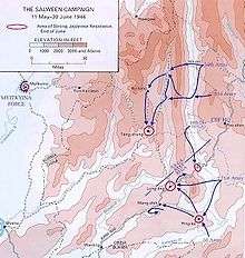
The river canyon was the scene of the Burma Campaign including the Salween Campaign in World War II, which was the final major battle fought by the Chinese against Japan in 1944–1945 in order to open up the blockaded Burma Road supply route from India, in combination with a second campaign to remove Japanese forces from northern Burma. During the war, this important route was the primary artery along which supplies travelled into Yunnan and then into the heart of China.
The Campaign involved Chinese troops led by American General Joseph Stilwell and assisted by US army air forces who crossed the upper Salween on 11 May 1944 in order to drive Japanese forces from Yunnan into northern Burma. On 11 May, about 40,000 Chinese of the Chinese Expeditionary Force crossed the Salween initially and a further 60,000 arrived later. About 17,000–19,000 Chinese and 15,000 Japanese were killed in the resulting battle. The higher number of Chinese casualties was caused by the fact that the Japanese had time to prepare their fortifications on the south side of the river. The Chinese continued to take towns and cities on the river back from Japan through 1945.[19]
World War II also marked the first time the Salween was used as a national border, as Burma ceded the lands of Shan State east of the Salween to Thailand, causing the river to become the national border for 120 kilometres (75 mi).[20]
Many of the natural resources in the Salween basin remained unexploited until the twentieth century as well. Prior to extensive logging activity in the upper watershed, the Salween's flow varied much less between the rainy and dry seasons, allowing for fertile riverbanks fed by soil deposits from the river. With the clear-cutting of the forests during the 20th century, specifically in 1997,[21] soil began to erode away in great amounts and was unable to hold water, thus lowering the river's baseflow during the dry season and causing floods of greater size during the monsoon. The erosion has also made the Salween very silty. The construction of logging roads made it even easier for Burmese interests to enter the area, exploiting other resources and severely damaging the native way of life.[22][23][24] Although strict limitations have been imposed on logging, illegal practices continue, including one in 2009 involving the discovery of teak logs floating in the river on the Thailand-Burma border.[21]
Dams

Since the 1970s, the countries along the river, especially China, have been pressing to build a series of hydroelectric and irrigation dams on the Salween River, some of which would be among the largest in the world if constructed.[3] The dams were proposed to generate more electricity for the growing population of China, help improve the power supply in surrounding regions of South Asia, and to divert water to irrigation in China, Thailand and Burma. As of 2013, China has not ratified the United Nations Convention on the Law of Non-Navigational Uses of International Watercourses which would regulate development, management, and use of transboundary waters such as the Salween.[25]
However, a series of problems have been associated with dams on the Salween. The Salween is one of the longest free-flowing rivers in Southeast Asia and is one of only two major free-flowing rivers in China.[3] The river supports thousands of species of plants and animals and is vital to the livelihoods of the many native cultures that live alongside it. It provides water for approximately 7-10 million people and supplies irrigation water to low-lying rice paddies abutting the Andaman Sea. Creating dams on the Salween would involve flooding hundreds of villages and towns and the reduced flow on the lower Salween would cause seawater to infiltrate inland, making the lower Salween valley unsuitable for growing crops. Because of poor logging practices in the upstream watershed, the historically silty Salween has become many times as turbid as its natural state. A reservoir on the Salween would fill much faster than projected, reducing the overall lifespan of dam projects. One of the largest problems is also that the dams would not have much positive impact on the people that actually live in the Salween region.[26] There have been many public outcries to damming the Salween, ranging from petitioning to large-scale protests.[27] There is also controversy over the representation of local opinion in the media. Investigative journalist Liu Jianqiang found little support for the dam projects among locals in China, who feared they would not get adequate compensation.[28] The damming has even been regarded as a "military thrust against" the native people, specifically the Karen people.[29]
In 2003, Huaneng Power International Inc. and the provincial government of Yunnan province, China, signed an agreement to build 13 dams and two reservoirs on the lower reaches of the Salween through Yunnan, some of which lie within the Three Parallel Rivers World Heritage Site.[30] One is said to be larger than the widely controversial Three Gorges Dam. In China, the dam proposals served as a watershed movement for a bourgeoning environmental movement, which mobilized in opposition to the project.[2] In response to protests, Chinese Premier Wen Jiabao, who was trained as a geologist,[25] announced in February 2004 a suspension of the dam project until a full environmental review could be conducted. The Chinese Ministry of the Environment also opposes the dams. Ultimately, the Chinese government announced it would reduce the 13-dam project to 4 dams, but controversy continued.[17] In May 2009, Wen again sought a suspension of the project pending environmental review, though one dam was already nearly complete on a tributary river. Analysts believed that the project will continue to move forward after Wen stepped down in 2012[31] which proved to be the case as extensive plans were revived in China for these and other projects in 2013. The number of proposed dams in the revived plan was reduced from 13 to 5.[25] In 2017, it was announced that, in response to widespread public opposition to damming the Nu River, the Yunnan provincial government intends to focus on protecting and transforming the river into a national park and eco-tourism attraction.[4][32]
The Thai and Burmese governments have also entertained proposals for the construction of dams on the river. On April 5, 2006 the Thai and Burma governments signed a $6 billion USD agreement to build the TaSang Dam. Another Thai-Burma project is for the Hatgyi Dam. A feasibility survey was started in May 2006, but was abandoned until sometime in 2007, due to a military offensive by the State Peace and Development Council against Karen people in the area. The dam's builder, the Electricity Generating Authority of Thailand, had hoped to have the feasibility study completed by April 2006, with construction to start in November 2007.[33] In July 2012, it was reported that the Burmese government was moving forward with construction of the Hatgyi dam.[34]

Dams in China
A total of 27 dams on the Salween (Nu River) in China are completed, under construction, cancelled or planned as of March 2014. Those dams are listed below from downstream to upstream.[35][36]
- Guangpo Dam – Cancelled, 700 MW
- Yansangshu Dam – Cancelled, 1,000 MW
- Saige Dam – Programmed, 1,000 MW
- Shitouzhai Dam – Cancelled, 440 MW
- Liuku Dam – Programmed, 180 MW
- Lushui Dam – Cancelled, 2,400 MW
- Yabiluo Dam – Programmed, 1,800 MW
- Bijiang Dam – Cancelled, 1,500 MW
- Fugong Dam – Cancelled, 400 MW
- Lumadeng Dam – Cancelled, 2,000 MW
- Maji Dam – Programmed, 4,200 MW
- Bingzhongluo Dam – Cancelled, 1,600 MW
- Songta Dam – Programmed, 3,600 MW
- Emi Dam – Planned.
- Angqu Dam – Planned.
- Luola Dam – Planned, 1050 MW
- Lalong Dam – Planned
- Yeba Dam – Planned
- Nujiangqiao Dam – Planned, 800 MW
- Kaxi Dam – Planned
- Tongka Dam – Planned
- Xinrong Dam – Planned, 420 MW
- Luohe Dam – Planned, 600 MW
- Reyu Dam – Planned, 1,050 MW
- Shading Dam – Planned, 210 MW
- Jiqian Dam – Completed, 2 MW
- Chalong Dam – Completed, 10.8 MW
Dams in Burma
At least seven dams are planned on the river's stretch in Burma. List below from upstream to downstream.[37]
- Kunlong Dam – Planned, 1,400 MW
- Nong Pha Dam – Planned
- Tasang Dam – Planned, 7,000 MW
- Ywathit Dam – Planned, 4,500 MW est.
- Weigyi Dam – Planned
- Dagwin Dam – Planned
- Hatgyi Dam – Planned, 1,365 MW
Tributaries
The Salwin's chief tributaries are the Nam Yu River, Nam Oi River, Hsipa Haw River, Nam Nim River, Nam Ting River, Nam Kyek River, Nam Nge River, Nam Nang River, Nam Kao River, Nam Hka River, and Nam Pang River — its largest tributary,— the Nam Hsim River, Me Sili River, and Me Sala River; the Nam Hang River, Nam Pang River, Nam Teng River, Nam Pawn River, the Thaung-yin River and the Yonzalin River.[38]
- Moei River
- Pang River
- Teng River
- Pawn River
- Hka River
- Pai River
- Yuam River
- Hsim River
- Ataran River
- Gyaing River
- Haungthayaw River
Protected areas
The Salween river flows through the following protected areas:
- Three Parallel Rivers of Yunnan Protected Areas (China)
- Salawin National Park (Thailand)[39]
- Salawin Wildlife Sanctuary (Thailand)
See also
References
- "Water Resources of Myanmar". AQUASTAT. Archived from the original on 2010-07-27. Retrieved 2010-09-21.
Website gives Salween discharge as 157 cubic kilometers per year, which translates to roughly 4,978 m3/s
- Yanfei Sun and Dingxin Zhao, "Environmental Campaigns," in Kevin O'Brien ed. Popular Protest in China, Harvard University Press, 2008.
-
Michael Buckley (2015-03-30). "The Price of Damming Tibet's Rivers". New York Times. New Delhi. p. A25. Archived from the original on 2015-03-31. Retrieved 2015-04-01.
Two of the continent’s wildest rivers have their sources in Tibet: the Salween and the Brahmaputra. Though they are under threat from retreating glaciers, a more immediate concern is Chinese engineering plans. A cascade of five large dams is planned for both the Salween, which now flows freely, and the Brahmaputra, where one dam is already operational.
- Yeophantong, Pichamon (2017). "River activism, policy entrepreneurship and transboundary water disputes in Asia". Water International. 42 (2): 163–186. doi:10.1080/02508060.2017.1279041.
- https://unstats.un.org/unsd/geoinfo/UNGEGN/docs/8th-uncsgn-docs/inf/8th_UNCSGN_econf.94_INF.75.pdf
- Chellaney, Brahma (15 September 2011). Water: Asia's New Battleground. Georgetown University Press. pp. 260–. ISBN 978-1-58901-771-9. Retrieved 29 September 2011.
- "Die Quelle des Saluen (= Nag Chu, Tibet)". Retrieved 2012-10-21.
- "Salween River". Ecoregions: Earth's most special places. World Wildlife Foundation. Retrieved 2009-12-03.
- "The Salween River". Salween Watch. Archived from the original on 2009-09-10. Retrieved 2009-12-03.
- Burma -Geography Archived 2012-02-07 at the Wayback Machine
- "Abstract" (PDF). Hydrogeographical Approach to the Upper Salween Basin USRB. Upper Salween River Basin USRB. Retrieved 2009-12-03.
- Drainage (Map). Cartography by University of Aberdeen. University of Aberdeen. Retrieved 2009-12-03.
- "The Marine Geological Record of Neogene Erosion in Asia: Interpreting the sedimentary record to understand tectonic and climatic evolution in the wake of India-Asia Collision". University of Aberdeen. Retrieved 2009-12-03.
- "New findings from Tibetan Plateau suggest uplift occurred in stages". UC Santa Cruz. 2008-03-24.
- "Nu (Salween) River". International Rivers. Retrieved 2009-12-04.
- "China's Nu River: Dam Projects Threaten Magnificent World Heritage Site" (PDF). International Rivers. Salween Watch. Retrieved 2009-12-04.
- "Salween River". Foundation for Ecological Recovery. Retrieved 2009-12-04.
- Ooi, Keat Gin (2004). Southeast Asia: a historical encyclopedia, from Angkor Wat to East Timor. 1. ABC-CLIO. p. 291. ISBN 978-1-57607-770-2.
- "Air Supply on the Salween River Front". The Quartermaster Review. U.S. Army Quartermaster Museum. March–April 1945.
- Southeast Asia: a historical encyclopedia, from Angkor Wat to East Timor, p. 327
- "Shipment of teak logs seized from Salween: Find raises prospect of new logging scandal". Bangkok Post. 2009-08-14. Retrieved 2009-12-05.
- "The Salween—my river, my natural belonging" (PDF). Watershed. Foundation for Ecological Recovery. November 1998 – February 1999. Retrieved 2009-12-04.
- Burma Project (2006-03-14). "Villagers in Burma Reject Plans to Dam the Salween River". EarthRights International. Retrieved 2009-12-04.
- "SPDC road construction plans creating problems for civilians". Karen Human Rights Group. 2006-01-27. Archived from the original on 2009-07-29. Retrieved 2009-12-04.
- Andrew Jacobs (May 4, 2013). "Plans to Harness Chinese River's Power Threaten a Region". The New York Times. Archived from the original on 2013-05-05. Retrieved May 5, 2013.
- "Flooding the future: Hydropower and Cultural Survival in the Salween River Basin". EarthRights International. Retrieved 2009-12-04.
- "Abhisit cool to opponents of Salween River dam project". Bangkok Post. 2009-11-24.
- Jianqiang, Liu (2007-02-28). "Fog on the Nu River". China Dialogue. Retrieved 2009-12-04.
- Talenywun, Don (2009-08-15). "The politics of dam construction along the Salween". Mizzima. Archived from the original on 2009-11-04. Retrieved 2009-12-04.
- Yardley, Jim (2005-12-23). "Vast dam proposal is a test for China". New York Times. Archived from the original on 2011-05-01. Retrieved 2009-12-04.
- Mitch Moxley, 'The fight to keep Nu River flowing', Global Post, 22 April 2010.
- The Mekong Eye. "Will Hydropower Turn the Tide on the Salween River?". Retrieved 10 June 2017.
- "Recent Dam and Water Diversion Plans". Salween Watch. Retrieved 2009-12-04.
- Charlie Campbell, Salween River Dammed by Peace, The Irrawaddy, 3 July 2012.
- Dong, Luan. "INTERACTIVE: Mapping China's "Dam Rush"". Wilson Center. Retrieved 15 June 2014.
- "The Last Report on China's Rivers". China's Rivers Report. March 2014. Retrieved 15 June 2014.
- "Current Status of Dam Projects on Burma's Salween River" (PDF). Salween Watch. 13 March 2013. Retrieved 16 November 2014.
- Beach, Frederick Converse; Rines, George Edwin (1908). The Americana: a universal reference library, comprising the arts and sciences, literature, history, biography, geography, commerce, etc., of the world (Now in the public domain. ed.). Scientific American compiling department. pp. 988–. Retrieved 29 September 2011.
- Salawin National Park website Archived 2009-01-15 at the Wayback Machine
Further reading
- Three Parallel Rivers of Yunnan Protected Areas at whc.unesco.org
- Three Parallel Rivers Protected Area at www.eoearth.org
- Nature Conservancy: Gongshan Nature Reserve The Nature Conservancy
- Rivers Watch East and Southeast Asia
- NuJiang River Project
- Hydrometeorological Approach to the Upper Salween River (USRB) - copyright by Dr. Christophe Lienert, Geographical Institute of the University of Berne and Kunming Institute of Botany
- China Rivers Project
- Last Descents River Expeditions
- A history of first raft and kayak descents of the Salween in Tibet and Yunnan, China.
External links
| Wikimedia Commons has media related to Salween River. |
- Phoel, Cynthia M., "Bargaining Power", in Oxfam Exchange, Fall 2004.
- Salween River Watch NGO
- Three Parallel Rivers of Yunnan Protected Areas
- Three Parallel Rivers Protected Area
- NuJiang River Project
- Salween First Descent
- Water Diversion from the Salween to the Chaophraya River
- Joint Statement of Concern by Shan Civil Society Organizations Regarding Public Meeting by Burmese Government and Hydrochina to Promote Dams on the Salween and Nam Ma Rivers