Min River (Fujian)
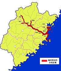
The Min River (simplified Chinese: 闽江; traditional Chinese: 閩江; pinyin: Mǐn Jiāng; Foochow Romanized: Mìng-gĕ̤ng; Pe̍h-ōe-jī: Bân-kang; Kienning Colloquial Romanized: Ma̿ing-gó̤ng) is a 577 kilometres (359 mi)-long river in Fujian province, People's Republic of China. It is the largest river in Fujian, and an important water transport channel. Most of northern and central Fujian is within its drainage area.
 | |
.svg.png) | |
| Native name | (simplified Chinese: 闽江; traditional Chinese: 閩江; pinyin: Mǐn Jiāng) (Chinese) |
|---|---|
| Physical characteristics | |
| Mouth | |
⁃ location | East China Sea |
| Length | 577 km (359 mi) |
| Basin size | 60,922 km2 (23,522 sq mi) |
| Discharge | |
| ⁃ average | 1,980 m3/s (70,000 cu ft/s) |
| Basin features | |
| Tributaries | |
| ⁃ left | Renshou, Jianxi and tributaries |
| ⁃ right | Xixi, Jinxi, Shaxi, Youxi, Dazhang |

The provincial capital, Fuzhou, sits on the lower Min River, with its historic center being on the northern side of the river, even closer to its fall into the East China Sea; the location historically made it an important port.
Alternate Source
The source of the Min River is generally regarded as the Bexi Brook, (which becomes known as the Futun after the inflow of the Xixi Brook) in the far northwest of the basin, for a total length of 577km. However, the furthest hydrological source is actually the Suixi Brook by 12.5km over the Bexi/Futun. Likewise, the point in the basin with the furthest straight line distance to the river mouth is the source of the Lanxi Brook. The Suixi and the Lanxi combine to form the Jinxi River, which itself probably contributes more water into the Min River System than the Futun at the point where the two rivers meet.
See also
| Wikimedia Commons has media related to Min River (Fujian). |
- List of rivers in China
- Min River (disambiguation) - for other rivers with the same name