Yalong River
The Yalong River (Chinese: 雅砻江, p Yǎlóngjiāng, w Ya-lung Chiang, IPA [jàlʊ̌ŋ tɕjàŋ]) or Nyag Chu (Tibetan: ཉག་ཆུ་, z Nyag Qu) is an 822-mile (1,323 km) long river in Sichuan province in southwestern China. It is a tributary of the Yangtze River. Its source is on the Tibet-Qinghai Plateau in southeast Qinghai, and its confluence with the Yangtze is in Panzhihua in southwestern Sichuan. Along its route, the Yalong travels between the Shaluli Mountains to the west and the Daxue Mountains to the east. In Liangshan Prefecture, the river wraps 150 km (93 mi) around the Jinping Mountains creating the Jinping Bend. Here, water from the Yalong River has been diverted under the mountains as part of the Jinping-II Dam hydroelectric project.
| Yalong River | |
|---|---|
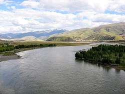 The Yalong River at Ganzi | |
 Map of the Yalong River drainage basin | |
| Location | |
| Country | China |
| Physical characteristics | |
| Source | Bayan Har Mountains |
| ⁃ coordinates | 34°12′27″N 97°36′24″E |
| ⁃ elevation | 4,920 m (16,140 ft) |
| Mouth | Yangtze River |
⁃ location | Panzhihua, Sichuan |
⁃ coordinates | 26°36′20″N 101°48′5″E |
⁃ elevation | 985 m (3,232 ft) |
| Length | 1,323 km (822 mi) |
| Basin features | |
| Tributaries | |
| ⁃ left | Anning |
| ⁃ right | Muli |
Dams
The Yalong is being heavily developed, primarily for hydroelectric power. A total of 23 dams are completed, under construction or planned for the river. Those dams are listed below from downstream to upstream.[1][2]
- Tongzilin Dam – Under construction, 600 MW
- Ertan Dam – Completed, 3,300 MW
- Guandi Dam – Completed, 2,400 MW
- Jinping 2 Dam – Completed, 4,800 MW
- Jinping 1 Dam – Completed, 3,600 MW
- Kala Dam – Programmed, 1,060 MW
- Yangfanggou Dam – Programmed, 2,200 MW
- Mengdigou Dam – Programmed, 1,700 MW
- Lenggu Dam – Planned, 2,300 MW
- Yagen Dam – Programmed, 1,500 MW
- Lianghekou Dam – Under construction, 3,000 MW
- Gongbagou Dam – Planned, 500 MW
- Gongke Dam – Planned, 400 MW
- Xinlong Dam – Planned, 500 MW
- Yingda Dam – Planned, 500 MW
- Tongha Dam – Planned, 200 MW
- Geni Dam – Planned, 200 MW
- Ada Dam – Planned, 250 MW
- Reba Dam – Planned, 250 MW
- Renqingling Dam – Planned, 300 MW
- Wenbosi Dam – Planned, 150 MW
- Danikanduo Dam – Planned, 7.2 MW
- Yangri Dam – Planned, 1 MW
Notes
- Dong, Luan. "INTERACTIVE: Mapping China's "Dam Rush"". Wilson Center. Retrieved 15 June 2014.
- "The Last Report on China's Rivers". China's Rivers Report. March 2014. Retrieved 15 June 2014.
References
- "Yalong River." Britannica Concise Encyclopedia. 2005. Encyclopædia Britannica Premium Service. 16 July 2005 <http://www.britannica.com/ebc/article?tocId=9383068>.
External links
- . New International Encyclopedia. 1905.