Kangxiwar
Kangxiwar (Chinese: 康西瓦; Uyghur: كەڭشىۋەر ; formerly Kengshewar[2]) is the location of a deserted town on the southwest side of the Kunlun Mountains. It is on the Karakash River in the western Xinjiang Uyghur Autonomous Region of the People's Republic of China. According to Chinese sources, Kangxiwar means "place with mine" in Uyghur.[3]
Kangxiwar | |
|---|---|
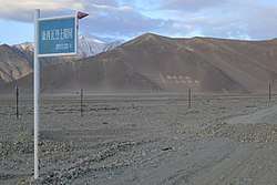 Kangxiwar memorial signage | |
 Kangxiwar  Kangxiwar | |
| Coordinates: 36°12′20″N 78°45′45″E | |
| Country | China |
| Region | Xinjiang |
| Prefecture | Hotan Prefecture |
| County | Pishan County |
| Township | Xaidulla |
| Elevation | 4,000 m (13,000 ft) |
| Kangxiwar | |||||||
|---|---|---|---|---|---|---|---|
| Chinese name | |||||||
| Traditional Chinese | 康西瓦 | ||||||
| Simplified Chinese | 康西瓦 | ||||||
| |||||||
| Uyghur name | |||||||
| Uyghur | كەڭشىۋەر | ||||||
| |||||||
Present day, there is a highway maintenance crew house and a military cemetery located here.[4] China National Highway 219 (G219), the Xinjiang-Tibet Highway, runs through here.[3] Following the G219 southeast will lead to Dahongliutan and Tianshuihai,[4] the latter of which is in Aksai Chin. China National Highway 580 is under construction connecting Kangxiwar directly with Hotan.[5] It is scheduled to be completed in 2022.[6]
Kangxiwar Daban[4] or Koshbel Pass[7][8] (lit. '"twin pass"'[9]) is a mountain pass located at the elevation of 4,250 metres (13,940 ft) downstream to the west.
History
Before modern era, the area was a thoroughfare of the caravan trade route between Leh and Tarim Basin. The Hindutash Pass, a historical mountain pass through the Kunlun Mountains is just north of here.[10] This place was previously referred to as Sumgal.[2] Literally meaning "three fords" in Tibetic languages,[11] it was a historical ford along with caravan camp. The caravan camp which had a shed[12] was located slightly downstream to the west on the north bank of the Karakash River[13][10] Another camp Ak-Koom was located slightly upstream to the east at the joining of two valleys.[14] During the 1860s at the time of Dungan Revolt, lawlessness led to the valley being frequented by Kyrgyz robbers who would capture caravans and sell the caravaners into slavery in Badakshan. A fort was setup down stream to the west at Xaidulla to help protect the caravans.[15]
By the 1930s, it was recorded by European travelers that a settlement of Kyrgyz nomads was located at Kangxiwar.[16][17]
During the 1962 Sino-Indian War, the PLA's Xinjiang Military Region headquarter was operated out of Kangxiwar,[18] although certain activities were supervised directly by People's Liberation Army General Staff Department.[19] The Chinese soldiers who perished during the Indo-China war were buried at a military cemetery in Kangxiwar along the G219 highway.[20][4] The cemetery contains the graves of over 100 PLA soldiers.[21]
See also
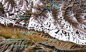 NASA satellite image showing the towns of Sumgal in Ladakh and Pusa in southwestern Hotan, and the Hindu-tash Pass connecting them. The pass is marked in bright red.
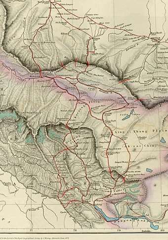 An 1878 traveller's map showing trade routes between Kashmir and the Tarim Basin. The route to Hotan vias the Hindutash Pass branches off from the Karakash valley at Kangxiwar. Warning: the lat/long information is not everywhere correct.
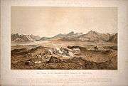 "The Chain of the Kuenlúen, from Súmgal, in Turkistán" by Hermann Schlagintweit
References
- Du Zheng; Qingsong Zhang; Shaohong Wu (2000). Mountain Geoecology and Sustainable Development of the Tibetan Plateau. Springer Science & Business Media. p. 352. ISBN 978-0-7923-6688-1.
Kangxiwar at an elevation of about 4000m asl has a precipitation of only 36.6 mm.
- Jeannette Hooft Visser; Jenny Visser-Hooft (1935). Wissenschaftliche ergebnisse der Niederländischen Expeditionen in den Karakorum und die angrenzenden gebiete in den jahren 1922, 1925 und 1929/30 (in German). In kommission bei F.A. Brockhaus. p. 14.
Sie folgten dem Kara-kash-Tal einige Kilometer nordwärts, um dann von Sumgal (gegenwärtig Kengshewar) über den Ilchi-davan (vermutlich der Paß, der jetzt Hindutash genannt wird) über das K'un-lun-Gebirge bis Bushia (jetzt Pusha)
- 国际展望 (Guoji Zhanwang / World Outlook Magazine) (21 March 2005). "专访中国海拔最高的烈士陵园" (in Chinese). Sina Military News. Retrieved 7 January 2020.
这就是被称为“新藏线”的219国道。在219国道的新疆段,人们可以很容易地找到一个以居民地形式标识的地形点——康西瓦。康西瓦,维语的意思是“有矿的地方”。
- "45 Days Ride along Dragon's Backbone: Kashgar to Lhasa". TibetTour.org. Retrieved 7 January 2020.
The milestone 425.5 marks Kangxiwa Daban which is 4250M-high. Ride down hard against the wind. When wading across two small rivers near to the interjection of Kangwaxi Revolutionary Martyrs Cemetery, you get to the destination today- the Kangxiwa High-way Keepers' House. ... Reach the Hongliutan ... ride to Tianshuihai Army Service Station
- Zeng, Tao-rui; Wang, Lin-feng (2019). "The Reliability and Stability Analysis of High Shear Slope in Cold Region Based on First Order Quadratic Matrix". Science Technology and Engineering. kns.ccpd.cnki.net (21). ISSN 1671-1815. Retrieved 7 January 2020.
Taking the K86 + 780 ~ K86 + 840 soil high cut slope of the highway section from Hetian to Kangxiwa of G580 line as an example,the reliability calculation of soil high cut slope in the cold region was carried out
- 中国交通新闻网 (18 November 2019). "580国道和康项目一标完成路面摊铺" [G580 Hotan-Kangxiwar Project first milestone completed, road surface paved]. Ministry of Transport of the People's Republic of China. Retrieved 7 January 2020.
日前,580国道新疆和田至康西瓦公路项目一标主线沥青路面完成摊铺,为2022年全线通车奠定了坚实基础。
- Lonely Planet; Stephen Lioy; Bradley Mayhew; Megan Eaves (1 May 2019). Lonely Planet Tibet. Lonely Planet Global Limited. p. 311. ISBN 978-1-78868-583-2.
The road climbs again over the 4250m Koshbel Pass to the truck stop of Dahongliutan (4200m), which offers basic food and lodging.
- "Koshbel Duban". dangerousroads.org. Retrieved 16 January 2020.
- Sven Anders Hedin; Nils Peter Ambolt (1967). Central Asia Atlas, Memoir on Maps: Index of geographical names, by D.M. Farquhar, G. Jarring and E. Norin. Sven Hedin Foundation, Statens etnografiska museum. p. 49.
'twin pass' ... Koshbel Dawan (of Kengshewar)
- Trotter, H. (1878). "On the Geographical Results of the Mission to Kashghar, under Sir T. Douglas Forsyth in 1873-74". Journal of the Royal Geographical Society of London. 48: 183. doi:10.2307/1798763. ISSN 0266-6235. JSTOR 1798763.
On the Kárákásh River, above Fotásh, is a camping-ground called Sumgal, from which Robert Schlagintweit crossed the Kuen Luen Range by the Hindu-tágh Pass, estimated by him at 17,379 feet high. ... The road by the Hindu-tágh Pass can only be used by foot-passengers.
- Journal of the Royal Asiatic Society of Great Britain and Ireland. Royal Asiatic Society of Great Britain & Ireland. 1863. p. 91.
Gsum "three" ... It is a name very frequent in Tíbet ... Súmgal, in Turkistán ... -- gsum rgal, "the three fords."
- Report on the Trade and Resources of the Countries on the North-western Boundary of British India. Printed at the Government Press. 1862. p. 22.
Sumgal - An "Aghil" or cattle shed in good pasture land in the Karakash valley.
- Adolf von Schlagintweit; Robert von Schlagintweit (1863). Results of a Scientific Mission to India and High Asia: Route-book of the western parts of the Himalaya, Tibet, and Central Asia : and geographical glossary from the languages of India and Tibet, including the phonetic transcription and interpretation. F. A. Brockhaus. p. 122.
A Sumgal, 36° 8', 78° 5'; 13,215 ft, on the right bank of the Karakásh river (fuel and grass abundant).
- Hayward, G. W. (1870). "Journey from Leh to Yarkand and Kashgar, and Exploration of the Sources of the Yarkand River". Journal of the Royal Geographical Society of London. 40: 33–166. doi:10.2307/1798640. ISSN 0266-6235. JSTOR 1798640.
(p33) middle of last map insert (p47) Near here, at Ak-koom, a wide valley known to the Kirghiz as Karajilga, joins from the eastward (p165) Ak-Koom 36°6'N 79°5'E
- Johnson, W. H. (1867). "Report on His Journey to Ilchi, the Capital of Khotan, in Chinese Tartary". Journal of the Royal Geographical Society of London. 37: 18–37. doi:10.2307/1798517. ISSN 0266-6235. JSTOR 1798517.
(p18) the risk of being taken captive and sold as a slave in Badakshan (p37) Shadula - Encampment near a guard-house
- Sven Anders Hedin; Nils Peter Ambolt (1968). Central Asia Atlas, Memoir on Maps: Records on surveys, by N.P. Ambolt and E. Norin. Sven Hedin Foundation, Statens etnografiska museum. p. 45.
Thus it was decided that Norin and Liu should go east as far as possible while Ambolt was to proceed to Kengshewar, the nearest inhabited place on the upper Karakash river, to meet an auxiliary caravan which had been organized by the Swedish missionaries at Yarkand on our request.
- The Geographical Journal. Royal Geographical Society. 1930. p. 508.
Only after crossing a side spur running down from the Kunlun range did we meet a small Qirghiz settement near Kengshewar.
- W. Mott; J. Kim (2 April 2006). The Philosophy of Chinese Military Culture: Shih vs. Li. Palgrave Macmillan US. pp. 143–. ISBN 978-1-4039-8313-8.
In response, China deployed two infantry regiments, several autonomous infantry battalions, and supporting artillery--about 6,300 soldiers--under the Xinjiang Military Region's Kangxiwa (Kangxiwar) Headquarters.
- M. Taylor Fravel (25 August 2008). Strong Borders, Secure Nation: Cooperation and Conflict in China's Territorial Disputes. Princeton University Press. p. 186. ISBN 978-1-4008-2887-6.
Moreover, if attacked, the PLA troops at Galwan were permitted to report directly to the GSD, not through the normal chain of command via the Kangxiwar headquarters and Xinjiang MD.
- Du, Wenjuan (1 January 2016). Tales from Tibet. Beijing Book Co. Inc. p. 138. ISBN 978-7-5001-4327-7.
When they walked into the Kangxiwar Martyrs' Cemetery a couple of days later, Zhang's master told him that the soldiers buried underneath died young in the Sino-Indian War in 1962.
- "驻疆某红军师官兵赴康西瓦烈士陵园缅怀先烈(组图)" [Xinjiang Red Army division visits Kangxiwar Martyrs Cemetery in memory of their sacrifice (gallery)] (in Chinese). People's Daily. 22 July 2015. Retrieved 7 January 2020.
海拔4280米的康西瓦革命烈士陵园,长眠着100多位为国捐躯的革命先烈。