Sultanhanı
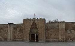
Sultanhanı is a town and district in Aksaray Province, Turkey. It is named after the famous han within the town. It became a district in 2017.
Sultanhanı | |
|---|---|
Town | |
 | |
 Sultanhanı Location in Turkey | |
| Coordinates: 38°15′N 33°33′E | |
| Country | |
| Province | Aksaray Province |
| Government | |
| • Body | Sultanhanı Municipality |
| Elevation | 945 m (3,100 ft) |
| Population (2019) | |
| • Total | 11,147 |
| Time zone | UTC+2 (EET) |
| • Summer (DST) | UTC+3 (EEST) |
| Area code(s) | 0382 |
| Licence plate | 68 |
| Website | http://www.sultanhani.bel.tr/ |
Geography
Sultanhanı is at 38°15′N 33°33′E. The distance to Aksaray is about 40 kilometres (25 mi) and to the south coast of Lake Tuz is 20 kilometres (12 mi). The population of the town is 11147 as of 2019 [1]
History
Presently, Sultanhanı is not on one of the main highways of Turkey. But it was one of the most important stops in caravan routes during the Middle Ages. The 4,866 square metres (52,380 sq ft) Seljuk han, which was commissioned by Alaattin Keykubat ('Alā' ad-Dīn Kay Qubād) is considered one of the best preserved hans of the Seljuk period.[2] After the age of discovery, like other caravan routes the Sultanhanı han became neglected.
Another milestone in local history was the Battle of Sultanhanı (also called the Battle of Aksaray) in 1256, where a Mongol army under the command of Baiju defeated the Seljuks.[3]
Economy
Although the land around Sultanhanı is quite salty, the town economy is flourishing. Main agricultural products are cereal and sugar cane, produced by mechanized agriculture. There is a sugar mill in the town. Another profitable business is ancient rug and carpet restoration. Some people are employed in stock breeding.
See also
References
- Population page
- "Sultanhanı" (in Turkish). Mayor. Retrieved 20 September 2011.
- Prof. Yaşar Yüce-Prof. Ali Sevim: Türkiye tarihi Cilt I, AKDTYKTTK Yayınları, İstanbul, 1991 p 130
Sultanhanı in Aksaray Province of Turkey | |||||||||||||||||||||||||||
|---|---|---|---|---|---|---|---|---|---|---|---|---|---|---|---|---|---|---|---|---|---|---|---|---|---|---|---|
| Districts | 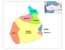 Districts of Aksaray | ||||||||||||||||||||||||||
| |||||||||||||||||||||||||||
Metropolitan municipalities are bolded. | |||||||||||||||||||||||||||