Ortaköy, Aksaray
Ortaköy is a town and district of Aksaray Province in the Central Anatolia region of Turkey, located north-west of the city of Aksaray, nearer to Kırşehir. According to 2000 census, population of the district is 58,873 of which 26,961 live in the town of Ortaköy.[3][4] The district covers an area of 725 km2 (280 sq mi),[5] and the average elevation is 1,140 m (3,740 ft).
Ortaköy | |
|---|---|
District | |
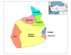 Location of Ortaköy, Aksaray within Turkey. | |
 Ortaköy Location of Ortaköy, Aksaray within Turkey. | |
| Coordinates: 38°44′10″N 34°02′25″E | |
| Country | |
| Region | Central Anatolia |
| Province | Aksaray |
| Government | |
| • Governor | Harun BAŞIBÜYÜK |
| • Mayor | Mahmut ÜTÜK (AKP) |
| Area | |
| • District | 725.19 km2 (280.00 sq mi) |
| Elevation | 1,140 m (3,740 ft) |
| Population (2012)[2] | |
| • Urban | 18,384 |
| • District | 35,519 |
| • District density | 49/km2 (130/sq mi) |
| Time zone | UTC+2 (EET) |
| • Summer (DST) | UTC+3 (EEST) |
| Postal code | 68xxx |
| Area code(s) | 0382 |
| Licence plate | 68 |
| Website | www.ortakoy.gov.tr |
This is a rural district centred on the small, quiet town of Ortaköy.
Places of interest
- Yunus Emre Türbesi - a tomb 25 km from the town, one of the many places in Turkey that claims to be the final resting place of the legendary folk-poet Yunus Emre.
Notes
- "Area of regions (including lakes), km²". Regional Statistics Database. Turkish Statistical Institute. 2002. Retrieved 2013-03-05.
- "Population of province/district centers and towns/villages by districts - 2012". Address Based Population Registration System (ABPRS) Database. Turkish Statistical Institute. Retrieved 2013-02-27.
- Turkish Statistical Institute. "Census 2000, Key statistics for urban areas of Turkey" (XLS) (in Turkish). Retrieved 2008-04-03.
- GeoHive. "Statistical information on Turkey's administrative units". Retrieved 2008-04-03.
- Statoids. "Statistical information on districts of Turkey". Retrieved 2008-04-21.
References
- Falling Rain Genomics, Inc. "Geographical information on Ortaköy, Turkey". Retrieved 2008-04-03.
- Turkish Ministry of Culture and Tourism. "General information on Ortaköy, Aksaray" (in Turkish). Archived from the original on 2016-03-04. Retrieved 2008-04-03.
External links
- District governor's official website (in Turkish)
- District municipality's official website (in Turkish)
- Aksaray governor's office (in Turkish, English, and French)
- Aksaray (in Turkish)
| Province: | ||
|---|---|---|
| District: |
| |
| Towns: | ||
| Villages: |
| |
Ortaköy, Aksaray in Aksaray Province of Turkey | |||||||||||||||||||||||||||
|---|---|---|---|---|---|---|---|---|---|---|---|---|---|---|---|---|---|---|---|---|---|---|---|---|---|---|---|
| Districts | Districts of Aksaray | ||||||||||||||||||||||||||
| |||||||||||||||||||||||||||
Metropolitan municipalities are bolded. | |||||||||||||||||||||||||||
This article is issued from Wikipedia. The text is licensed under Creative Commons - Attribution - Sharealike. Additional terms may apply for the media files.