Shediac
Shediac (2016 population: 6,664[1]) is a Canadian town in Westmorland County, New Brunswick. The town is known as the "Lobster Capital of the World" and hosts an annual festival every July which promotes its ties to lobster fishing. At the western entrance to the town is a 90-ton sculpture called The World's Largest Lobster.[2]
Shediac | |
|---|---|
Town | |
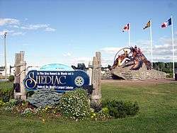 Entrance to the town | |
Seal  Coat of arms | |
| Nickname(s): Lobster Capital of the World | |
| Motto(s): | |
 Shediac | |
| Coordinates: 46.2195°N 64.54403°W | |
| Country | Canada |
| Province | New Brunswick |
| County | Westmorland County |
| Parish | Shédiac Parish |
| Founded | 18th century |
| Incorporated | 1903 |
| Government | |
| • Type | Town Council |
| • Mayor | Roger Caissie |
| • Governing Body | Shediac Town Council |
| Area | |
| • Total | 53.95 km2 (20.83 sq mi) |
| Elevation | Sea level to 33 m (0 to 108.3 ft) |
| Population (2016)[1] | |
| • Total | 6,664 |
| • Density | 123.5/km2 (320/sq mi) |
| Time zone | UTC-4 (Atlantic (AST)) |
| • Summer (DST) | UTC-3 (ADT) |
| Canadian Postal code | E4P |
| Area code(s) | 506 |
| Telephone Exchange | 312 351 530 531 532 533 |
| NTS Map | 021I02 |
| GNBC Code | DACUC |
| Highways | |
| Website | http://www.shediac.org |
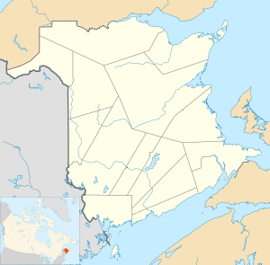
Geography
Shediac is situated primarily on Route 133 around Shediac Bay, a sub-basin of the Northumberland Strait.
.jpg)
The town is located southwest and adjacent to the community of Pointe-du-Chêne, once the eastern terminus of the European and North American Railway as well as a stopover for Pan-Am's transatlantic "clipper" air service featuring large seaplanes. Imperial Airways' flying boat service to Foynes in Ireland also used the facilities.
History
Hundreds of years ago, the Mi'kmaq encampment of "Es-ed-ei-ik" was one of the major camps in southeast New Brunswick. The Mi'kmaq word "Es-ed-ei-ik" which means "running far in" (in reference to the tide, which has a long range over the shallow, sandy beaches) eventually transformed into Gédaique.[3]
Acadians first arrived at Shediac in 1751 as a result of the Acadian Exodus from peninsular Nova Scotia.[4] During the French and Indian War, French officer Charles Deschamps de Boishebert made his headquarters at both Shediac and Cocagne, New Brunswick. In the autumn of 1755, Boishebert established himself on the south shore of Cocagne Bay, a place known as Boishebert's Camp. The following year, Boishebert moved to Miramichi, New Brunswick, specifically to Beaubears Island.[5] After the war, Acadians returned to the region in 1767.
Today many Francophone residents use the spelling Shédiac; however, the town's name upon its incorporation did not feature an accented "e", and correspondingly the official geographic name for the community is Shediac.
Shediac Bay Yacht Club
Shediac Bay Yacht Club is on the Register of 'Canada's Historic Places' for being the location of a local wharf for nearly a century. The previous Shediac Bay Yacht Club House was designed by Roméo Savoie.[6]
Demographics
|
Income (2015)[1]
|
Mother tongue (2016)[1]
| |||||||||||||||||||||||||||||||||||||||||||||||||||||||||||||||||||||||||||||
Notable people
| |
New Brunswick | |

| |
| Location | Shediac New Brunswick Canada |
|---|---|
| Coordinates | 46°14′26.12″N 64°31′50.05″W |
| Year first constructed | 1914 (first) |
| Year first lit | n/a (current) |
| Foundation | concrete base |
| Construction | wooden building |
| Tower shape | 2-storey square prism building surmounted by a square frustum with balcony and octagonal prism lantern |
| Markings / pattern | white building, red lantern roof and range line |
| Tower height | 14 metres (46 ft)[7] |
| Focal height | 12 metres (39 ft)[7] |
| Light source | main power |
| Range | 22 nautical miles (41 km; 25 mi)[7] |
| Characteristic | Iso Y 4s. |
| Admiralty number | H1332.1 |
| CHS number | CCG 1111 |
| NGA number | 7748 |
| ARLHS number | CAN-940[8] |
- Georges-Antoine Belcourt (1803–1874), missionary
- Edna May Williston Best (1880–1923), feminist
- Emile Duprée (1936 – ), former professional wrestler and promoter
- René Duprée (1983 – ), professional wrestler, former WWE wrestler, son of Émile Dupree
- Muriel McQueen Fergusson (1899–1987), Canadian senator
- Gord Gallant (1950 – ), professional hockey player
- Placide Gaudet (1850–1930), journalist, historian
- Daniel Lionel Hanington (1835–1909), former Premier of New Brunswick
- Rosa Laricchiuta (1974 – ), professional singer
- Joseph E. Leblanc (born 1916), politician
- Samuel Lee (1756–1805), judge, politician
- Anna Malenfant (1905–1988), singer, educator and composer
- Edward R. McDonald (1872–1952), lawyer, politician, mayor, inventor of the Crossword Game, 1926
- Olivier-Maximin Melanson (1854–1926), Acadian businessman and politician
- A. P. Paterson (1870–1957), politician
- Scott Pellerin (b. 1970), former professional hockey player
- Pascal Poirier (1852–1933), writer, lawyer, senator
- Jean George Robichaud (1883–1969), politician
- Ferdinand Joseph Robidoux (1875–1962), lawyer, politician
- Wes Sheridan, Canadian politician
- Albert James Smith (1822–1883), former Premier of New Brunswick
- Ernest A. Smith (1864 – ?), Canadian politician
- Elsie Wayne (1932–2016), politician
- John Clarence Webster (1862–1950), physician, historian
See also
References
- "Census Profile, 2016 Census: Shediac, New Brunswick". Statistics Canada. Retrieved August 18, 2019.
- "BigThings.ca: Town of Shediac, New Brunswick". Big Things: The Monuments of Canada. Retrieved November 12, 2014.
- Rand, Silas Tertius (January 1, 1875). A First Reading Book in the Micmac Language: Comprising the Micmac Numerals, and the Names of the Different Kinds of Beasts, Birds, Fishes, Trees, &c. of the Maritime Provinces of Canada. Also, Some of the Indian Names of Places, and Many Familiar Words and Phrases, Translated Literally Into English. Nova Scotia Printing Company.
- Webster, p. 3
- Webster, p. 5
- "Shediac Bay Marina". Canada's Historic Places. Parks Canada. Retrieved August 18, 2019.
- List of Lights, Pub. 110: Greenland, The East Coasts of North and South America (Excluding Continental U.S.A. Except the East Coast of Florida) and the West Indies (PDF). List of Lights. United States National Geospatial-Intelligence Agency. 2016.
- "Northern New Brunswick". The Lighthouse Directory. University of North Carolina at Chapel Hill. Retrieved April 2, 2017.
Further reading
- Webster. A History of Shediac. 1928
- Belliveau, John Edward (2003) Running Far In: The Story of Shediac. Halifax, Nova Scotia: Nimbus Publishing Ltd, ISBN 1-55109-431-2
Bordering communities
Places adjacent to Shediac | ||||||||||
|---|---|---|---|---|---|---|---|---|---|---|
| ||||||||||
External links
| Wikimedia Commons has media related to Shédiac. |
| Subdivisions |
|
|---|---|
| Cities | |
| Towns | |
| |
| Authority control |
|
|---|