South Khorasan Province
South Khorasan Province (Persian: استان خراسان جنوبی Ostān-e Khorāsān-e Jonūbī ) is a province located in eastern Iran. Birjand is the centre of the province. The other major cities are Ferdows, Tabas and Qaen. In 2014, it was placed in Region 5.[3]
South Khorasan Province استان خراسان جنوبی | |
|---|---|
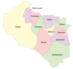 South Khorasan counties | |
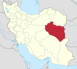 Location of South Khorasan Province in Iran | |
| Coordinates: 32.8653°N 59.2164°E | |
| Country | |
| Region | Region 5 |
| Capital | Birjand |
| Counties | 11 |
| Area | |
| • Total | 151,913 km2 (58,654 sq mi) |
| Population (2016)[1] | |
| • Total | 768,898 |
| • Density | 5.1/km2 (13/sq mi) |
| Time zone | UTC+03:30 (IRST) |
| • Summer (DST) | UTC+04:30 (IRST) |
| Main language(s) | Persian |
| HDI (2017) | 0.757[2] high · 27th |
| Website | sko.ir |
| South Khorasan Province Historical population | ||
|---|---|---|
| Year | Pop. | ±% |
| 2006 | 700,852 | — |
| 2011 | 732,642 | +4.5% |
| 2016 | 768,898 | +4.9% |
| amar.org.ir Includes all areas that were not part of the province during the previous censuses | ||
This new province, is but the old Quhistan which was included into greater Khorasan in the Iranian administrative planning. However, historically Qohistan forms a separate entity, with a distinct culture, history, environment and ecology.
South Khorasan is one of the three provinces that were created after the division of Khorasan in 2004. While at the beginning, the newly created "South Khorasan" included only Birjand County and some new counties detached from that county (i.e. Nehbandan, Darmian and Sarbisheh), in subsequent years, all northern and western cities and territories of the old Quhistan (such as Qaen, Ferdows and Tabas) have been annexed into the South Khorasan.
South Khorasan Province consists of 11 counties: Birjand County, Ferdows County, Tabas County, Qaen County, Nehbandan County, Darmian County, Sarbisheh County, Boshruyeh County, Sarayan County, Zirkuh County and Khusf County.
History

Greater Khorasan has witnessed the rise and fall of many dynasties and governments in its territory throughout history. Various tribes of the Arabs, Turks, Kurds,[4] Mongols, Turkemen and Afghans brought changes to the region time and time again.
Ancient geographers of Iran divided Iran ("Iran-Shahr") into eight segments of which the most flourishing and largest was the territory of Greater Khorasan. Esfarayen, among other cities of the province, was one of the focal points for residence of the Aryan tribes after entering Iran.
The Parthian empire was based near Merv in Khorasan for many years. In Parthians times, Esfarayen was one of the important villages of Nishapur.
During the Sassanid dynasty the province was governed by a Spahbod (Lieutenant General) called "Padgoosban" and four margraves, each commander of one of the four parts of the province.
Khorasan was divided into four parts during the Muslim conquest of Persia, each section being named after the four largest cities, Nishapur, Merv, Herat, and Balkh.
In the year 651, the army of Islamic Arabs invaded Khorasan. The territory remained in the hands of the Abbasid clan until 820, followed by the rule of the Iranian Taherid clan in the year 896 and the Samanid dynasty in 900.
Mahmud of Ghazni conquered Khorasan in 994 and in the year 1037 Toghrül, the first of the Seljuq empire rulers conquered Nishapur.
Mahmud of Ghazni retaliated against the invaders several times, and finally the Ghaznavids defeated Sultan Sanjar. But there was more to come, as in 1157 Khorasan was conquered by the Khwarazmids and because of simultaneous attacks by the Mongols, Khorasan was annexed to the territories of the Mongol Ilkhanate.
In the 14th century, a flag of independence was hoisted by the Sarbedaran movement in Sabzevar, and in 1468, Khorasan came into the hands of Tamerlane and the city of Herat was declared as capital.
In 1507, Khorasan was occupied by Uzbek tribes. After the death of Nader Shah in 1747, parts of it were occupied by the Afghans for a short period.
In these periods, Birjand was a small part of Quhistan which almost encompasses the borders of today South Khorasan. The main cities of Quhistan were Toon (now Ferdows) and Qaen. Birjand grew in recent centuries, especially during the Qajar dynasty and found its important role in this region.
This region was a place of refuge for some movements like the Ismaili, and was the target of Arab refugees who escaped from the tyranny of the Abbasid caliphate. Zoroastrian vestiges also exist in the area.
During the Qajar period, Britain supported the Afghans to protect their East India Company. Herat was thus separated from Persia, and Nasser-al-Din Shah was unable to defeat the British to take back Herat. Finally, the Paris Treaty was concluded in 1903 and Iran was compelled not to challenge the British for Herat and other parts of what is today Afghanistan.
Finally Khorasan was divided into two parts: the eastern part, which was the most densely populated region came under British occupation, and the other western section remained part of Iran.
Khorasan was the largest province of Iran until it was divided into three provinces on September 29, 2004. The provinces approved by the parliament of Iran (on May 18, 2004) and the Council of Guardians (on May 29, 2004) were Razavi Khorasan, North Khorasan, and South Khorasan.
South Khorasan today
The major ethnic groups in this region are the Persians, as well as sizeable ethnic Baloch and Pashtun populations.[5] South Khorasan is known for its famous rugs as well as its saffron, barberry which are produced in almost all parts of the province.

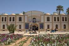
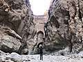
Attractions
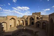
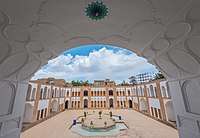
South Khorasan has many historical and natural attractions, but besides these, South Khorasan encompasses various religious buildings and places of pilgrimage as well.
The Cultural Heritage of Iran lists 1179 sites of historical and cultural significance in all three provinces of Khorasan.
Some of the popular attractions of South Khorasan are:
Colleges and universities
- University of Birjand
- Birjand University of Medical Sciences
- Islamic Azad University of Birjand
- Islamic Azad University of Ferdows
- Birjand University of Technology[6]
- Payame Noor University [7]
- University of Applied Science and Technology (south khorasan branch)
- Academy of Tarbiat-e Moalem
- Academy of Amuzesh-e Aly
- Academy of Amuzesh-e Modiriat Dolaty


See also
- Khorasan
- Razavi Khorasan
- North Khorasan
References
- "National census 2016". amar.org.ir. Retrieved 2017-03-14.[]
- "Sub-national HDI - Area Database - Global Data Lab". hdi.globaldatalab.org. Retrieved 2018-09-13.
- "همشهری آنلاین-استانهای کشور به ۵ منطقه تقسیم شدند (Provinces were divided into 5 regions)". Hamshahri Online (in Persian). 22 June 2014 (1 Tir 1393, Jalaali). Archived from the original on 23 June 2014. Check date values in:
|date=(help) - "Kurds in Khorasan". CSKK. Retrieved 2014-08-12.
- "Ethnologue report for Southern Pashto: Iran (1993)". SIL International. Ethnologue: Languages of the World. Retrieved 5 May 2012.
- http://www.birjandut.ac.ir
- http://www.skpnu.ac.ir
External links
- The text of the law for division of Khorasan into three provinces (in Persian)
- Cultural Heritage Foundation of Khorasan
Places adjacent to South Khorasan Province | |
|---|---|
| Capital |  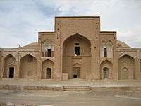 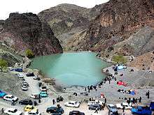 | ||||||||||||||||||||||
|---|---|---|---|---|---|---|---|---|---|---|---|---|---|---|---|---|---|---|---|---|---|---|---|
| Counties and cities |
| ||||||||||||||||||||||
| Sights |
| ||||||||||||||||||||||
| populated places | |||||||||||||||||||||||
| Authority control |
|
|---|