Fars Province
Fars Province (/fɑːrs/; Persian: استان فارس, Ostān-e Fārs, pronounced [ˈfɒː(ɾ)s]), also known as Pars (پارس, Pārs) as well as Persis and Persia,[5] is one of the thirty-one provinces of Iran. With an area of 122,400 km², it is located in Iran's southwest, in Region 2,[6] and its administrative center is Shiraz. As of 2011, Fars had a population of 4.6 million people, of which 67.6% were registered as urban dwellers (urban/suburbs), 32.1% villagers (small town/rural), and 0.3% nomad tribes.[7]
Fars Province استان فارس | |
|---|---|
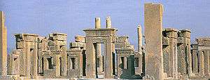
.jpg) 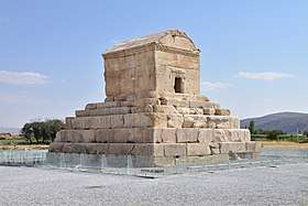 _(cropped).JPG) .jpg) _(cropped).jpg) 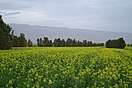 Clockwise from top: The Tomb of Cyrus the Great in Pasargadae, Arg of Karim Khan in Shiraz, a canola field in Alamarvdasht, Bishapur valley, Naqsh-e Rostam, and ruins of the Tachara in Persepolis. | |
 Location of Fars within Iran | |
| Coordinates: 29°37′N 52°32′E | |
| Country | |
| Region | Region 2 |
| Capital | Shiraz |
| Counties | 36 |
| Area | |
| • Total | 122,608 km2 (47,339 sq mi) |
| Population (2016)[1] | |
| • Total | 4,851,274 |
| • Estimate (2020) | 5,051,000[2] |
| • Density | 40/km2 (100/sq mi) |
| Time zone | UTC+03:30 (IRST) |
| • Summer (DST) | UTC+04:30 (IRST) |
| Area code(s) | 071 |
| Main language(s) | Persian Qashqai Luri[3][4] Dialects of Fars |
| Fars Province Historical population | ||
|---|---|---|
| Year | Pop. | ±% |
| 2006 | 4,336,878 | — |
| 2011 | 4,596,658 | +6.0% |
| 2016 | 4,851,274 | +5.5% |
| amar.org.ir | ||
Fars is the historical homeland of the Persian people.[8][9] It was the homeland of the Achaemenid and Sasanian Persian dynasties of Iran, who reigned on the throne by the time of the ancient Persian Empires. The ruins of the Achaemenid capitals Pasargadae and Persepolis, among others, demonstrate the ancient history of the region. Due to the historical importance of this region, the entire country has historically been also referred to as Persia in the West.[9][10]
Etymology
The Persian word Fârs (فارس) is the Arabized form of the earlier form Pârs (پارس), which is in turn derived from Pârsâ (𐎱𐎠𐎼𐎿), the Old Persian name for the Persis region. The names Parsa and Persia originate from this region.[11]
History
Persis

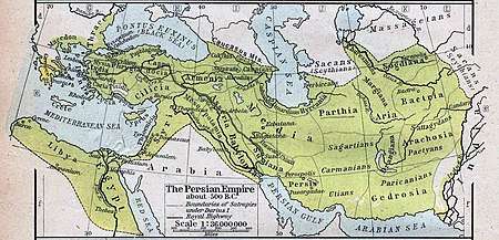
The ancient Persians were present in the region from about the 10th century BC, and became the rulers of the largest empire the world had yet seen under the Achaemenid dynasty which was established in the mid 6th century BC, at its peak stretching from Thrace-Macedonia, Bulgaria-Paeonia and Eastern Europe proper in the west, to the Indus Valley in its far east.[12] The ruins of Persepolis and Pasargadae, two of the four capitals of the Achaemenid Empire, are located in Fars.
The Achaemenid Empire was defeated by Alexander the Great in 333 BC, incorporating most of their vast empire. Shortly after this the Seleucid Empire was established. However it never extended its power in Fars beyond the main trade routes, and by the reign of Antiochus I or possibly later Persis emerged as an independent state that minted its own coins.[13]
The Seleucid Empire was subsequently defeated by the Parthians in 238 BC, but by 205 BC, the Seleucid king Antiochus III had extended his authority into Persis and it ceased to be an independent state.[14]
Babak was the ruler of a small town called Kheir. Babak's efforts in gaining local power at the time escaped the attention of Artabanus IV, the Parthian Arsacid Emperor of the time. Babak and his eldest son Shapur I managed to expand their power over all of Persis.
The subsequent events are unclear, due to the sketchy nature of the sources. It is however certain that following the death of Babak around 220, Ardashir who at the time was the governor of Darabgird, got involved in a power struggle of his own with his elder brother Shapur. The sources tell us that in 222, Shapur was killed when the roof of a building collapsed on him.
At this point, Ardashir moved his capital further to the south of Persis and founded a capital at Ardashir-Khwarrah (formerly Gur, modern day Firouzabad).[15] After establishing his rule over Persis, Ardashir I rapidly extended the territory of his Sassanid Persian Empire, demanding fealty from the local princes of Fars, and gaining control over the neighboring provinces of Kerman, Isfahan, Susiana, and Mesene.
Artabanus marched a second time against Ardashir I in 224. Their armies clashed at Hormizdegan, where Artabanus IV was killed. Ardashir was crowned in 226 at Ctesiphon as the sole ruler of Persia, bringing the 400-year-old Parthian Empire to an end, and starting the virtually equally long rule of the Sassanian Empire, over an even larger territory, once again making Persia a leading power in the known world, only this time along with its arch-rival and successor to Persia's earlier opponents (the Roman Republic and the Roman Empire); the Byzantine Empire.
The Sassanids ruled for 425 years, until the Muslim armies conquered the empire. Afterwards, the Persians started to convert to Islam, this making it much easier for the new Muslim empire to continue the expansion of Islam.
Persis then passed hand to hand through numerous dynasties, leaving behind numerous historical and ancient monuments; each of which has its own values as a world heritage, reflecting the history of the province, Iran, and West Asia. The ruins of Bishapur, Persepolis, and Firouzabad are all reminders of this. Arab invaders brought about a decline of Zoroastrian rule and made Islam ascendant from the 7th century.
Administrative divisions
Fars province is located in the south of Iran. It neighbours Bushehr Province to the west, Hormozgān Province to the south, Kerman and Yazd provinces to the east, Isfahan province to the north and Kohgiluyeh and Boyer-Ahmad Province to the northwest. According to the latest divisions, the province contains the following counties: Abadeh, Sarvestan, Jahrom, Eqlid, Rostam, Estahban, Darab, Nayriz, Bavanat, Larestan, Qir and Karzin, Khorrambid, Lamerd, Kazerun, Fasa, Firuzabad, Zarrin Dasht, Mamasani, Shiraz, Marvdasht, Sepidan, Arsanjan, Pasargad, Kavar, Khonj, Farashband, Gerash, Kharameh, Mohr.
Climate and wildlife
There are three distinct climatic regions in the Fars Province. First, the mountainous area of the north and northwest with moderate cold winters and mild summers. Secondly, the central regions, with relatively rainy mild winters, and hot dry summers. The third region located in the south and southeast, has cold winters with hot summers. The average temperature of Shiraz is 16.8 °C, ranging between 4.7 °C and 29.2 °C.[16]
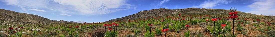
The geographical and climatic variation of the province causes varieties of plants; consequently, variation of wildlife has been formed in the province. Additional to the native animals of the province, many kinds of birds migrate to the province every year.[17] Many kinds of ducks, storks and swallows migrate to this province in an annual parade. The main native animals of the province are gazelle, deer, mountain wild goat, ram, ewe and many kinds of birds. In the past, like in Khuzestan Plain, the Persian lion had occurred here.[18][19]
The province of Fars includes many protected wildlife zones. The most important protected zones are:
- Toot Siah (Black Berry) Hunt Forbidden Zone, which is located at the end of Boanat region.
- Basiran Hunt Forbidden Zone, which is located 4 kilometers south to Abadeh;
- Bamu National Park, which is located north-east of Shiraz;
- Estahban Forest Park (Parke Jangaly), which is located on the outskirts of Touraj mountain;
- Hermoodlar Protected Zone, which is located east to Larestan.[17]
Arjan Meadow 22 km2 (8.5 sq mi) and Lake Parishan 40 km2 (15 sq mi) are designated Wetlands of International Importance under the Ramsar convention.

Economy
Agriculture is of great importance in Fars.[20] The major products include cereal (wheat and barley), citrus fruits, dates, sugar beets and cotton. Fars has major petrochemical facilities, along with an oil refinery, a factory for producing tires, a large electronics industry, and a sugar mill. Tourism is also a large industry in the province. UNESCO has designated an area in the province, called Arzhan (known as Dasht e Arjan) as a biosphere reserve. Shiraz, provincial capital of Fars, is the namesake of Shirazi wine. A large number of wine factories existed in the city.
Demographics
The main ethnic group in the province constitutes of Persians (including Larestani people and the Basseri), while Qashqai, Lurs, Kurds, Arabs, Georgians, and Circassians constitute minorities.[21]
Due to the geographical characteristics of Fars and its proximity to the Persian Gulf, Fars has long been a residing area for various peoples and rulers of Iran. However, the tribes of Fars including, Mamasani Lurs, Khamseh and Kohkiluyeh have kept their native and unique cultures and lifestyles which constitute part of the cultural heritage of Iran attracting many tourists.
Among the hundreds of thousands of Georgians and Circassians that were transplanted to Persia under Shah Abbas I, his predecessors, and successors, a certain amount of them were to guard the main caravan routes; many were settled around Āspās and other villages along the old Isfahan-Shiraz road. By now the vast majority Caucasians that were settled in Fars have lost their cultural, linguistic, and religious identity, having mostly being assimilated into the population.[21]
The province has a population of 4.6 million approximately.
Most Populous Cities
The following sorted table, lists the most populous cities in Fars with a population of more than 50,000 according to 2016 Census results announced by Statistical Center of Iran.[22] Aftar Shiraz, Marvdasht, Jahrom, and Fasa are the most populous cities of the province.
| Rank | City | County | Date of Official Foundation of Municipality |
Population |
|---|---|---|---|---|
| 1 | Shiraz | Shiraz | 1907 | 1,565,572 |
| 2 | Marvdasht | Marvdasht | 1950 | 148,858 |
| 3 | Jahrom | Jahrom | 1925 | 141,634 |
| 4 | Fasa | Fasa | 1926 | 110,825 |
| 5 | Kazerun | Kazerun | 1931 | 96,683 |
| 6 | Sadra | Shiraz | 2009 | 91,863 |
| 7 | Darab | Darab | 1930 | 70,232 |
| 8 | Firuzabad | Firuzabad | 1944 | 65,417 |
| 9 | Lar | Larestan | 1938 | 62,045 |
| 10 | Abadeh | Abadeh | 1925 | 59,116 |
| 11 | Nurabad | Mamasani | 1962 | 57,058 |
Transportation
Shiraz Airport is the main international airport of the province and the second in the country. The cities of Jahrom, Lar and Lamerd also have airports linking them with Shiraz and Tehran and nearby Persian Gulf countries such as the UAE and Bahrain. Shiraz is along the main route from Tehran to southern Iran.
Higher education
The Fars Province is home to many higher education institutes and universities. The main universities of the province include Shiraz University, Shiraz University of Medical Sciences,[23] Shiraz University of Technology, Jahrom University, Jahrom University of Medical Sciences, Fasa University of Medical Sciences, Islamic Azad University of Shiraz and Islamic Azad University of Jahrom.
Notable people
- Mansur Hallaj Persian mystic, killed in the 9th century AD.
- Salman the Persian A companion of the Islamic prophet Muhammad and the first Persian who converted to Islam.
- Saadi, writer, poet, born and died in Shiraz.
- Hafez Shirazi, poet, born and died in Shiraz.
- Mulla Sadra an Iranian Shia Islamic philosopher and theologian.
- Qotb al-Din Kazeruni was born in Kazerun.
- Reza Malekzadeh was born in Kazerun.
- Christiane Amanpour's father is originally from Sarvestan, Fars.
- Sibawayh, one of the founders of Arabic grammar, died in Shiraz.
- Karim Khan, founder of the Zand dynasty.
- Lotf Ali Khan, the last ruler of the Zand dynasty.
- Barbad, the Persian musician of the Sassanid era, born in Jahrom
- Hakim Salman Jahromi, The special doctor of Abbas the Great was from Jahrom
- Ibn Muqaffa, or Ruzbeh Dadwayh, Persian writer and translator from the 8th century AD.
- Zahra Kazemi, photographer, born in Shiraz.
- Ladan and Laleh Bijani, famous conjoined twins, born in Shiraz.
- Khwaju Kermani, buried in Shiraz.
- Jamshid Amouzegar
- Seyyed Zia'eddin Tabatabaee was born in Shiraz.
- Ibn Khafif, a 9th-century sage, is buried in Shiraz.
- Sheikh Ruzbehan
- Afshin Ghotbi, Football Manager of Iranian National Team
- Meulana Shahin Shirazi, Persian Jewish poet and wiseman.
- Junayd Shirazi
- Mohsen Kadivar
- Ata'ollah Mohajerani was a representative of Shiraz in the Majlis.
- Saeed Emami
- Gholam Reza Azhari
- Siyyid Mírzá 'Alí-Muhammad, the Báb
- Mohammad Hashem Pesaran, the most honored Iranian economist.
- Firouz Naderi, an Iranian-American scientist and the Associate Director of NASA's Jet Propulsion Laboratory (JPL), responsible for Project Formulation and Strategy. He was born in Shiraz.
- Ebrahim Golestan, filmmaker and literary figure
- Kaveh Golestan, photojournalist and artist.
- Habibollah Peyman, Iranian politician
- Mohsen Safaei Farahani, Iranian politician
- Simin Daneshvar, academic, renowned novelist, fiction writer and translator
References
- "National census 2016". amar.org.ir. Retrieved 2017-03-14.[]
- https://amar.org.ir/%D8%AF%D8%A7%D8%AF%D9%87%D9%87%D8%A7-%D9%88-%D8%A7%D8%B7%D9%84%D8%A7%D8%B9%D8%A7%D8%AA-%D8%A2%D9%85%D8%A7%D8%B1%DB%8C/%D8%AC%D9%85%D8%B9%DB%8C%D8%AA-%D9%88-%D9%86%DB%8C%D8%B1%D9%88%DB%8C-%DA%A9%D8%A7%D8%B1/%D8%AC%D9%85%D8%B9%DB%8C%D8%AA#55811019--
- "پرتال سازمان ميراث فرهنگي، صنایع دستی و گردشگري > استانها > فارس > آداب و رسوم". 11 January 2012. Archived from the original on 11 January 2012.
- http://www.sil.org/iso639-3/documentation.asp?id=luz
- Sykes, Percy (1921). A History of Persia. London: Macmillan and Company. p. 43.
- "استانهای کشور به ۵ منطقه تقسیم شدند" [The Provinces of the Country Were Divided Into 5 Regions]. Hamshahri Online (in Persian). 22 June 2014. Archived from the original on 23 June 2014.
- "National Population and Housing Census, 2011".
- Austin, Peter (1 January 2008). One Thousand Languages: Living, Endangered, and Lost. University of California Press. ISBN 9780520255609 – via Google Books.
- Xavier de Planhol (24 January 2012). "FĀRS i. Geography". Encyclopædia Iranica. IX. pp. ?–336.
The name of Fārs is undoubtedly attested in Assyrian sources since the third millennium B.C.E. under the form Parahše. Originally, it was the "land of horses" of the Sumerians (Herzfeld, pp. 181-82, 184-86). The name was adopted by Iranian tribes which established themselves there in the 9th century B.C.E. in the west and southwest of Urmia lake. The Parsua (Pārsa) are mentioned there for the first time in 843 B.C.E., during the reign of Salmanassar III, and then, after they migrated to the southeast (Boehmer, pp. 193-97), the name was transferred, between 690 and 640, to a region previously called Anšan (q.v.) in Elamite sources (Herzfeld, pp. 169-71, 178-79, 186). From that moment the name acquired the connotation of an ethnic region, the land of the Persians, and the Persians soon thereafter founded the vast Achaemenid empire. A never-ending confusion thus set in between a narrow, limited, geographical usage of the term—Persia in the sense of the land where the aforesaid Persian tribes had shaped the core of their power—and a broader, more general usage of the term to designate the much larger area affected by the political and cultural radiance of the Achaemenids. The confusion between the two senses of the word was continuous, fueled by the Greeks who used the name Persai to designate the entire empire. It lasted through the centuries of Arab domination, as Fārs, the term used by Muslims, was merely the Arabicized version of the initial name.
- M. A. Dandamaev (1989). A Political History of the Achaemenid Empire. BRILL. pp. 4–6. ISBN 9004091726.
- Zangiabadi, A., and M. Akbari. "Assessment and Analysis of Development Indicator in Township of Fars Province." (2011): 113-122.
- David Sacks, Oswyn Murray, Lisa R. Brody; Oswyn Murray; Lisa R. Brody (2005). Encyclopedia of the ancient Greek world. Infobase Publishing. pp. 256 (at the right portion of the page). ISBN 978-0-8160-5722-1.CS1 maint: multiple names: authors list (link)
- The Cambridge History of Iran, Vol. 3 (1), p. 299
- The Cambridge History of Iran, Vol. 3 (1), p. 302
- Kaveh Farrokh (2007). Shadows in the Desert: Ancient Persia at War. Osprey Publishing. pp. 176–9. ISBN 9781846031083.
- کشور, پورتال سازمان هواشناسی. "اقلیم استان فارس". www.irimo.ir.
- "Iran fars-shiraz". www.irantour.org.
- Humphreys, P., Kahrom, E. (1999). Lion and Gazelle: The Mammals and Birds of Iran. Images Publishing, Avon.
- Firouz, E. (2005). The complete fauna of Iran. I. B. Tauris. pp. 5–67. ISBN 978-1-85043-946-2.
- "Farmers' participation in agricultural development: The case of Fars province, Iran". www.indjst.org.
- P. Oberling, "FĀRS vii. Ethnography", Encyclopaedia Iranica>"FĀRS vii. Ethnography". 31 May 2014.
- https://www.amar.org.ir/english
- Various scholars/contributors (2013). Issues in Discovery, Experimental, and Laboratory Medicine: 2013 Edition. Scholarly Editions. pp. 139–40. ISBN 9781490109169.
Bibliography
- W. Barthold (1984). "Fars". An Historical Geography of Iran. Translated by Svat Soucek. Princeton University Press. pp. 148–168. ISBN 978-1-4008-5322-9.
External links
| Wikivoyage has a travel guide for Fars. |
| Wikimedia Commons has media related to Fars Province. |
- Province of Fars on Iran Chamber Society
- Houchang E. Chehabi (ed.). "Regional Studies: Fars". Bibliographia Iranica. USA: Iranian Studies Group at MIT. (Bibliography)
- Fars Tourist Attractions
Places adjacent to Fars Province | |
|---|---|

| Authority control |
|
|---|