Kerman Province
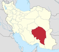
Kerman Province (Persian: استان کرمان, Ostān-e Kermān) is the largest province of the 31 provinces of Iran. Kerman is in the southeast of Iran with its administrative center in the city of Kerman. In 2014 it was placed in Region 5.[4] Mentioned in ancient times as the Achamenid satrapy of Carmania,[5] it is the largest province of Iran with an area of 183,285 km2 (70,767 sq mi), that encompasses nearly 11 percent of the land area of Iran.[6] The population of the province is about 3 million (9th in the country).
Kerman Province استان کرمان | |
|---|---|
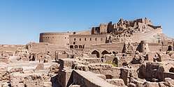 Bam Fortress (2016) | |
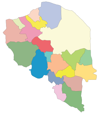
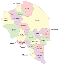 Kerman Province and its counties | |
 | |
| Coordinates: 30.2907°N 57.0679°E | |
| Country | |
| Region | Region 5 |
| Capital | Kerman |
| Counties | 23 |
| Government | |
| • Governor | TBD |
| Area | |
| • Total | 183,285 km2 (70,767 sq mi) |
| Elevation | 192 m (630 ft) |
| Population (2016)[1] | |
| • Total | 3,164,718 |
| • Density | 17/km2 (45/sq mi) |
| Time zone | UTC+03:30 (IRST) |
| • Summer (DST) | UTC+04:30 (IRST) |
| Main language(s) | Persian, Garmsiri [2] |
| HDI (2017) | 0.778[3] high · 20th |
| Website | www.gov.kr.ir |
History and culture

Kerman province is considered a paradise for palaeontologists because of an abundance of vertebrate fossils from different geological eras. Fossils include Placodermi, jawed and jawless armoured fish dating back to the Devonian period (395 to 365 million years ago), dinosaurs (195 to 66 million years ago) and mammals from the Tertiary period (ranging from two to seventy million years ago).
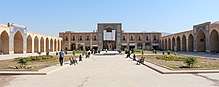
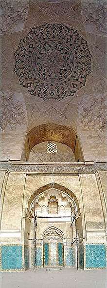
The history of human settlements in the territory of Kerman dates back to the 4th millennium BC. This area is considered as one of the ancient regions of Iran and valuable historical vestiges have been discovered here. Jiroft is an example, where a previously unknown settlement dating back to around 2500 BC has been established by archeologists. Kerman has an abundance of historical sites and landmarks, 283 in total, according to Iran's Cultural Heritage Organization. Ancient abandoned citadels such as Arg-e Bam and Rayen Castle have been preserved in the desert for 2,000 years.
Historical documents refer to Kerman as "Karmania" (in Ancient Greek Καρμανία), "Kermania", "Germania", "Carmonia", and "Žermanya", which means bravery and combat. Geographers have recorded Kerman's ancient name as "Go'asheer" (Bardesheer).
Geography
The altitudes and heights of the province are the continuation of the central mountain ranges of Iran. They extend from the volcanic folds beginning in Azarbaijan and, by branching out in the central plateau of Iran, terminate in Baluchestan. These mountain ranges have brought about vast plains in the province. The Bashagard and Kuhbonan Mountains are the highest in this region and include peaks such as Toghrol, Aljerd, Palvar, Sirach, Abareq and Tahrood. Other ranges that stretch out from Yazd to Kerman and Challeh-ye-Jazmoorian include high peaks like Hazaran 4501 meters above sea level, Kuh-e Shah 4402 meters, Joupar, Bahr Aseman and Khabr mountain in Khabr National Park and others.
Most of the province is largely steppe or sandy desert, although there are some oases where dates, oranges (said to be the best in Iran), and pistachios are cultivated. In antiquity "Carmanian" wine was famed for its quality [Strabo XV.2.14 (cap. 726)]. The province is dependent on qanats (underground water channels) for its irrigation. In the central parts, Mount Hezar is the highest peak, 4501 meters above sea level.
Kerman is prone to natural disasters. A recent flood for example, unearthed the archeological ancient city of Jiroft, in the south of Kerman province. Arg-é Bam on the other hand, the world's largest adobe structure, was destroyed in an earthquake in December 2003. On February 22, 2005, a major earthquake killed hundreds of residents in the town of Zarand and several nearby villages in north Kerman (see 2005 Zarand earthquake).
Counties
The counties of Kerman province are Baft County, Bardsir County, Bam County, Jiroft County, Rafsanjan County, Zarand County, Sirjan County, Shahr-e-Babak County, Kerman County, Kahnuj County, Qaleh Ganj County, Manujan County, Rudbar-e Jonubi County, Anbarabad County, Rabor County, Rigan County, Arzuiyeh County, Fahraj County, Faryab County and Ravar County.
Climate
The climate in the province varies across regions. The north, northwest, and central areas experience a dry and moderate climate, whereas in the south and southeast, the weather is warm and relatively humid. The city of Kerman and the surrounding regions have a semi-moderate and dry climate, with a maximum and minimum temperature of 39.6 °C, and -7 °C, respectively. The average temperature during the months of March–June has been recorded as 20°-25 °C. These months are the most suitable for traveling and tourism.
Demography
Most of the population of Kerman are Persians, and Shi'a Muslims. There is a minority of Baloch population living in the south of Kerman Province and are predominantly Sunni. Kerman also has a small but culturally significant Zoroastrian minority.
In 2011 the population of the province was 2,938,988 (1,482,339 male; 1,456,649 female) in 786,400 households. 1,684,982 lived in urban areas, 1,242,344 in rural vicinities and 6,082 accounted as non-residents.[7]
In 1996, 52.9% of Kerman's population lived in urban areas, and 46% in rural vicinities, the remaining 1.1% accounted as non-residents. In 2006 urban population made 58.5%, in 2011 this rate decreased by one percent.[8] The city of Kerman (2011 population: 621,374) embraces about 80% of the urban population, being the most developed and largest city of the province.
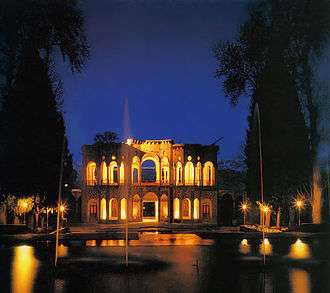
Attractions
Natural attractions include thermal and mineral springs, recreational areas, verdant spaces, altitudes and peaks, lakes, pools, protected areas and the special desert features for adventure seekers.
Economy
As of 1920, the province was known for the quality of its caraway.[9] Today, Kerman is where a large portion of Iran's auto industry is based. Sirjan, a specially designated economic zone, is considered a passageway for transfer of imported commercial goods from the south (through the Persian Gulf). Arg e Jadid, is another specially designated economic zone of Iran, located in Kerman province. Furthermore, Kerman Province is famous for its abundance of pistachio fields both in the city itself and surrounding ones such as Rafsanjan, Ravar and Nooq. [10]
Education
Colleges and universities
Kerman province contains the following universities:
See also
- Kirman (Sasanian province)
- Kerman Province parliamentary districts (related to the Islamic Consultative Assembly)
- List of monuments in Kerman Province
- Carmania (satrapy)
- Dalfard
References
- National Census 2006
- Habib Borjian, “KERMAN xvi. LANGUAGES,” Encyclopædia Iranica, XVI/3, pp. 301-315, available online at http://www.iranicaonline.org/articles/kerman-16-languages
- "Sub-national HDI - Area Database - Global Data Lab". hdi.globaldatalab.org. Retrieved 2018-09-13.
- "همشهری آنلاین-استانهای کشور به ۵ منطقه تقسیم شدند (Provinces were divided into 5 regions)". Hamshahri Online (in Persian). 22 June 2014. Archived from the original on 23 June 2014.
- "CARMANIA". iranicaonline.org.
- http://www.sci.org.ir/content/userfiles/_sci_en/sci_en/sel/year85/f1/CS_01_4.HTM%5B%5D
- amar.org.ir
- Selected Findings of National Population and Housing Census, 2011 Archived 2013-05-31 at the Wayback Machine
- Sykes, Percy (1921). A History of Persia. London: Macmillan and Company. p. 75.
- http://www.kerman-info.ir/608-2
- Edward Balfour (1885), "Kirman", Cyclopaedia of India (3rd ed.), London: B. Quaritch – via HathiTrust
- Guy Le Strange (1905). "Kirman". Lands of the Eastern Caliphate. Cambridge University Press. p. 299 – via Internet Archive.
- "Kerman", Encyclopaedia Britannica (11th ed.), New York, 1910, OCLC 14782424
- W. Barthold (1984). "Quhistan, Kirman, and Makran". An Historical Geography of Iran. Translated by Svat Soucek. Princeton University Press. pp. 133–147. ISBN 978-1-4008-5322-9.
External links
![]()
- "Kerman". Encyclopædia Iranica.
- Houchang E. Chehabi (ed.). "Regional Studies: Kerman". Bibliographia Iranica. USA: Iranian Studies Group at MIT. (Bibliography)
- Kerman Specially Designated Economic Zone
Places adjacent to Kerman Province | ||||||||||
|---|---|---|---|---|---|---|---|---|---|---|
| ||||||||||
| Capital |  | |
|---|---|---|
| Counties and cities | ||
| Sights |
| |
| Places | ||
| Authority control |
|
|---|