Chaharmahal and Bakhtiari Province
Chaharmahal and Bakhtiari Province (Persian: استان چهارمحال و بختیاری, Ostān-e Chahār-Mahāl-o Bakhtiyārī ) is one of the 31 provinces of Iran. It lies in the southwestern part of the country. Its capital is Shahr-e Kord.
Chahar Mahaal and Bakhtiari Province استان چهارمحال و بختیاری | |
|---|---|
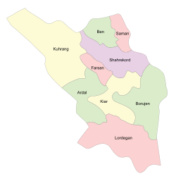 Counties of Chaharmahal and Bakhtiari Province | |
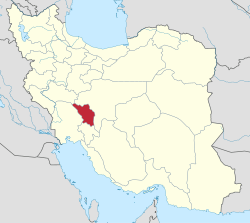 Location of Chaharmahal and Bakhtiari Province in Iran | |
| Coordinates: 32.3275°N 50.8546°E | |
| Country | |
| Region | Region 2 [1] |
| Capital | Shahrekord |
| Counties | 10 |
| Government | |
| • Governor | Eghbal Abasi |
| Area | |
| • Total | 16,332 km2 (6,306 sq mi) |
| Population (2016)[2] | |
| • Total | 947,763 |
| • Density | 58/km2 (150/sq mi) |
| Time zone | UTC+03:30 (IRST) |
| • Summer (DST) | UTC+04:30 (IRST) |
| Main language(s) | Bakhtiari Lurish Persian Qashqai Turkish |
| HDI (2017) | 0.798[3] high · 13th |
| Chaharmahal and Bakhtiari Province Historical population | ||
|---|---|---|
| Year | Pop. | ±% |
| 2006 | 843,784 | — |
| 2011 | 895,263 | +6.1% |
| 2016 | 947,763 | +5.9% |
| amar.org.ir | ||
The province was classified as part of Region 2 upon the division of the provinces into 5 regions solely for coordination and development purposes on June 22, 2014.[1]
It has an area of 16,332 square kilometers, and had a population of 895,263 in 2011.[4]
The history of the province is tied largely to that of the Bakhtiari tribe. The Bakhtiari tribe can be divided into two sub-tribes, Haft Lang and Chahar Lang, with various territorial affiliations. They are the main speakers of Lurish language. As the name of the province indicates, the other group of people in this ancient province are the Chahar Mahali. These people and the Lur speakers live side by side and share nearly similar customs. In addition, individuals have intermarried between these groups. The cities of Shahr-e Kord, Broujen, Ben, Naafch and Saman are within the Chahar Mahali area of the province. The Lur do not generally live here. The Bakhtiari territories at times have also come under Isfahan and Khuzestan province.
The people of this province have had a subsistence economy. They have gained a reputation as excellent, if not the best, horsemen in Iran. The people of this province have practiced the Pahlevani wrestling/combat style of the traditional Zurkhane, which is practiced in all provinces. But they also have their own style of wrestling/unarmed combat as do other provinces. It is called jangi ("jang" means "war" and hence "jangi" "war-ish" or "warlike").
The people have other specific customs associated with their tribal lives. Special forms of music, dance, and clothing are noteworthy.
Administrative divisions
Counties (Shahrestans)
| Map | Shahrestan (≈County) | Bakhsh (≈District) | District Center |
|---|---|---|---|
| Ardal | Central | Ardal | |
| Miankooh | Sarkhun | ||
| Boroojen | Central | Boroojen | |
| Boldaji | Boldaji | ||
| Gandoman | Gandoman | ||
| Farsan | Central | Farsan | |
| Koohrang | Central | Chelgerd | |
| Bazoft | Bazoft | ||
| Doab-Samsami | Samsami | ||
| Kiar | Central | Shalamzar | |
| Naghan | Naghan | ||
| Lordegan | Central | Lordegan | |
| Falard | Mal-e Khalifeh | ||
| Khanmirza | Aluni | ||
| Manj | Manj | ||
| Shahr-e Kord | Central | Shahr-e Kord | |
| Ben | Ben | ||
| Laran | Soureshjan | ||
| Saman | Saman |

Economy
The province is mainly active in the agriculture sector. Most of the industrial sector is clustered around the center of the province.
The province has the potential to become a vibrant tourist attraction because of its natural resources.[15]
Colleges and universities
- Islamic Azad University of Borujen
- Islamic Azad University, Shahrekord Branch[16]
- Shahrekord University
- Shahrekord University of Medical Sciences
References
- "استانهای کشور به ۵ منطقه تقسیم شدند". همشهری آنلاین. June 22, 2014. Retrieved July 21, 2019.
- "National census 2016". amar.org.ir. Retrieved 2017-03-14.[]
- "Sub-national HDI - Area Database - Global Data Lab". hdi.globaldatalab.org. Retrieved 2018-09-13.
- "Archived copy" (PDF). Archived from the original (PDF) on 2013-05-31. Retrieved 2013-09-28.CS1 maint: archived copy as title (link) National Census 2011
- Geomatics and Cartographic Research Centre, Carleton University. "Atlas built on CouchDb". iranatlas.net. Retrieved July 21, 2019.
- Geomatics and Cartographic Research Centre, Carleton University. "Atlas built on CouchDb". iranatlas.net. Retrieved July 21, 2019.
- In Erik Anonby, Mortaza Taheri-Ardali, et al. (eds.). 2015-2017. Atlas of the Languages of Iran. Ottawa: Geomatics and Cartographic Research Centre, Carleton University. Online address: http://iranatlas.net (retrieved December 3, 2017).
- Geomatics and Cartographic Research Centre, Carleton University. "Atlas built on CouchDb". iranatlas.net. Retrieved July 21, 2019.
- Anonby, Erik, Mortaza Taheri-Ardali, et al. (eds.). 2015-2017. Atlas of the Languages of Iran. Ottawa: Geomatics and Cartographic Research Centre, Carleton University. Online address: http://iranatlas.net (retrieved December 3, 2017).]
- Anonby, Erik, Mortaza Taheri-Ardali, et al. (eds.). 2015-2017. Atlas of the Languages of Iran: Chahar Mahal va Bakhtiari language map. Ottawa: Geomatics and Cartographic Research Centre, Carleton University. Online address: (retrieved December 4, 2017).
- Anonby, Erik, Mortaza Taheri-Ardali, et al. (eds.). 2015-2017. Atlas of the Languages of Iran: Languages of Chahar Mahal va Bakhtiari Province, Iran. Ottawa: Geomatics and Cartographic Research Centre, Carleton University. Online address: (retrieved December 4, 2017).
- Khosravi, Abdol’ali. 1996/1375. Guyesh-e Bakhtiāri: Ketāb-e chahārom [Bakhtiari dialect: Fourth book]. Esfahan: Nashr-e Ghazal.
- Tāheri, Esfandyār. 2010/1389. Guyesh-e Bakhtiāri-ye Kuhrang [The Bakhtiari dialect of Kuhrang]. Tehran: IHCS Press.
- Madadi, Zohrāb. 1996/1375. Vāzhehnāmeh-ye zabān-e Bakhtiāri [Lexicon of the Bakhtiari language]. Tehran & Esfahan: Enteshārāt-e Āyāt.
- "Choghakhor to become a tourist hub by 2008". www.payvand.com. Retrieved July 21, 2019.
- "Islamic Azad University Shahrekord Branch - About Shahrekord". August 15, 2011. Archived from the original on August 15, 2011. Retrieved July 21, 2019.
External links
| Wikimedia Commons has media related to Chaharmahal and Bakhtiari Province. |
- Official website of Chahar Mahaal and Bakhtiari Governorship
- Provincial Bureau for Budget, Planning, and Management (سازمان مدیریت و برنامه ریزی)
- Shahrekord Municipality (شهرداری شهرکرد)
- Provincial Bureau for Telecommunications (شرکت مخابرات)
- Provincial Bureau of Industries and Mines
- (in Persian) Provincial Department of Transportation (سازمان حمل و نقل و پایانهها)
- (in Persian) Provincial Bureau of Economics and Finance Affairs (سازمان امور اقتصادی و دارائی)
- (in Persian) Provincial Department of Education (سازمان آموزش و پرورش)
- Provincial Bureau of Taavon (اداره کل تعاون)
- Provincial Department of Utilities (سازمان آب وفاضلاب روستایی)
- Shahrekord Central Post Office (اداره کل پست)
- Provincial Department of Medical Insurance (بیمه خدمات درمانی)
- (in Persian) Provincial Bureau of Agricultural Jihad (سازمان جهاد کشاورزی)
- (in Persian) Provincial Welfare Organization (سازمان بهزیستی)
- (in Persian) Provincial Department of Social Security (اداره کل تامین اجتماعی)
- (in Persian) Provincial Meteorological Service (اداره کل هواشناسی)
- Chahar Mahal va Bakhtiyari Attractions
- Atlas of the Languages of Iran (ALI) - Chaharmahal and Bakhtiari
Places adjacent to Chaharmahal and Bakhtiari Province | ||||||||||
|---|---|---|---|---|---|---|---|---|---|---|
| ||||||||||
| Capital |  | ||||||||||||||||||||
|---|---|---|---|---|---|---|---|---|---|---|---|---|---|---|---|---|---|---|---|---|---|
| Counties and cities |
| ||||||||||||||||||||
| Landmarks |
| ||||||||||||||||||||
| populated places | |||||||||||||||||||||
Lurish languages in Iran and Iraq | ||
|---|---|---|
|  Lurish Language Map | |
Source for percentages is the Ethnologue. | ||
| Authority control |
|
|---|