Skjervøy
Skjervøy (Northern Sami: Skiervvá suohkan; Kven: Kieruan komuuni) is a municipality in Troms og Finnmark county, Norway. The administrative centre of the municipality is the village of Skjervøy on the island of Skjervøya, where most of the inhabitants live. The main industries are fishing and shipbuilding.
Skjervøy kommune Skiervvá suohkan Kieruan komuuni | |
|---|---|
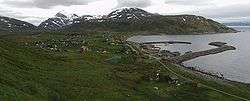 View of the village of Årviksand | |
 Coat of arms  Troms og Finnmark within Norway | |
 Skjervøy within Troms og Finnmark | |
| Coordinates: 70°05′07″N 20°39′34″E | |
| Country | Norway |
| County | Troms og Finnmark |
| District | Nord-Troms |
| Established | 1 Jan 1838 |
| Administrative centre | Skjervøy |
| Government | |
| • Mayor (2015) | Ørjan Albrigtsen (KrF/Kp) |
| Area | |
| • Total | 473.70 km2 (182.90 sq mi) |
| • Land | 464.99 km2 (179.53 sq mi) |
| • Water | 8.71 km2 (3.36 sq mi) 1.8% |
| Area rank | 212 in Norway |
| Population (2020) | |
| • Total | 2,927 |
| • Rank | 230 in Norway |
| • Density | 6.3/km2 (16/sq mi) |
| • Change (10 years) | 1.6% |
| Demonym(s) | Skjervøyværing[1] |
| Time zone | UTC+01:00 (CET) |
| • Summer (DST) | UTC+02:00 (CEST) |
| ISO 3166 code | NO-5427 |
| Official language form | Bokmål[2] |
| Website | skjervoy |
The 474-square-kilometre (183 sq mi) municipality is the 212nd largest by area out of the 356 municipalities in Norway. Skjervøy is the 230th most populous municipality in Norway with a population of 2,927. The municipality's population density is 6.3 inhabitants per square kilometre (16/sq mi) and its population has increased by 1.6% over the previous 10-year period.[3][4]
General information
The municipality of Skjervøe (later spelled Skjervøy) was established on 1 January 1838 (see formannskapsdistrikt). In 1863, the southeastern (inland) part of the municipality (population: 1,677) was separated to form the new Kvænangen Municipality. This left 2,785 people in Skjervøy. Then on 1 January 1886 the southern part of the municipality (population: 1,057) was separated from Skjervøy to form the new Nordreisa Municipality. This left 2,096 inhabitants in Skjervøy.
On 1 January 1890, the Trætten and Loppevolden farms (population: 32) were transferred from Skjervøy to Nordreisa. On 1 January 1965, the Meilands area (population: 12) was transferred to Kvænangen. On 1 January 1972, the parts of Skjervøy lying on the mainland (population: 1,556) were transferred from Skjervøy to Nordreisa, and the uninhabited Mannskarvik farm was transferred to Kvænangen. Then on 1 January 1982 the southern part of the island of Uløya (population: 128) was transferred from Skjervøy to Nordreisa.[5]
On 1 January 2020, the municipality became part of the newly formed Troms og Finnmark county. Previously, it had been part of the old Troms county.[6]
Name
The municipality (originally the parish) is named after the small island of Skjervøya (Old Norse: Skerføy), since the first Skjervøy Church was built there. The first element is skerf which means "rocky ground" and the last element is øy which means "island". Before 1909 the name was written Skjervø, and earlier it was spelled Skjervøe.[7]
Coat of arms
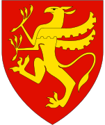
The coat of arms is from modern times; they were granted on 27 March 1987. The arms show the black head of a cormorant on a silver background, partly canting since skarf means cormorant. The cormorant also symbolizes the coastal municipality, which (like the bird) is dependent on fishing for its living. The cormorant is also a common bird in the area.[8]
Churches
The Church of Norway has one parish (sokn) within the municipality of Skjervøy. It is part of the Nord-Troms prosti (deanery) in the Diocese of Nord-Hålogaland.
| Parish (Sokn) | Church Name | Location of the Church | Year Built |
|---|---|---|---|
| Skjervøy | Arnøy Church | Arnøyhamn | 1978 |
| Skjervøy Church | Skjervøy | 1728 |
History
Skjervøy Church dates back to 1728 and it is the oldest wooden church in Troms county. The village of Maursund is an old trading post with well-preserved 19th-century houses.
Government
All municipalities in Norway, including Skjervøy, are responsible for primary education (through 10th grade), outpatient health services, senior citizen services, unemployment and other social services, zoning, economic development, and municipal roads. The municipality is governed by a municipal council of elected representatives, which in turn elect a mayor.[9] The municipality falls under the Nord-Troms District Court and the Hålogaland Court of Appeal.
Municipal council
The municipal council (Kommunestyre) of Skjervøy is made up of 19 representatives that are elected to four year terms. The party breakdown of the council is as follows:
| Party Name (in Norwegian) | Number of representatives | |
|---|---|---|
| Labour Party (Arbeiderpartiet) | 2 | |
| Progress Party (Fremskrittspartiet) | 3 | |
| Conservative Party (Høyre) | 1 | |
| Christian Democratic Party (Kristelig Folkeparti) | 6 | |
| Centre Party (Senterpartiet) | 5 | |
| Joint list of the Red Party (Rødt) and the Socialist Left Party (Sosialistisk Venstreparti) | 2 | |
| Total number of members: | 19 | |
| Party Name (in Norwegian) | Number of representatives | |
|---|---|---|
| Labour Party (Arbeiderpartiet) | 4 | |
| Progress Party (Fremskrittspartiet) | 3 | |
| Conservative Party (Høyre) | 1 | |
| Centre Party (Senterpartiet) | 4 | |
| Socialist Left Party (Sosialistisk Venstreparti) | 2 | |
| Joint list of the Christian Democratic Party (Kristelig Folkeparti) and the Coastal Party (Kystpartiet) | 5 | |
| Total number of members: | 19 | |
| Party Name (in Norwegian) | Number of representatives | |
|---|---|---|
| Labour Party (Arbeiderpartiet) | 3 | |
| Progress Party (Fremskrittspartiet) | 2 | |
| Conservative Party (Høyre) | 2 | |
| Christian Democratic Party (Kristelig Folkeparti) | 1 | |
| Coastal Party (Kystpartiet) | 7 | |
| Centre Party (Senterpartiet) | 2 | |
| Socialist Left Party (Sosialistisk Venstreparti) | 2 | |
| Total number of members: | 19 | |
| Party Name (in Norwegian) | Number of representatives | |
|---|---|---|
| Labour Party (Arbeiderpartiet) | 3 | |
| Progress Party (Fremskrittspartiet) | 3 | |
| Conservative Party (Høyre) | 1 | |
| Christian Democratic Party (Kristelig Folkeparti) | 1 | |
| Coastal Party (Kystpartiet) | 7 | |
| Centre Party (Senterpartiet) | 2 | |
| Socialist Left Party (Sosialistisk Venstreparti) | 2 | |
| Total number of members: | 19 | |
| Party Name (in Norwegian) | Number of representatives | |
|---|---|---|
| Labour Party (Arbeiderpartiet) | 4 | |
| Progress Party (Fremskrittspartiet) | 2 | |
| Conservative Party (Høyre) | 1 | |
| Christian Democratic Party (Kristelig Folkeparti) | 7 | |
| Centre Party (Senterpartiet) | 2 | |
| Socialist Left Party (Sosialistisk Venstreparti) | 3 | |
| Total number of members: | 19 | |
| Party Name (in Norwegian) | Number of representatives | |
|---|---|---|
| Labour Party (Arbeiderpartiet) | 4 | |
| Conservative Party (Høyre) | 3 | |
| Christian Democratic Party (Kristelig Folkeparti) | 14 | |
| Centre Party (Senterpartiet) | 1 | |
| Socialist Left Party (Sosialistisk Venstreparti) | 3 | |
| Total number of members: | 25 | |
| Party Name (in Norwegian) | Number of representatives | |
|---|---|---|
| Labour Party (Arbeiderpartiet) | 12 | |
| Conservative Party (Høyre) | 9 | |
| Christian Democratic Party (Kristelig Folkeparti) | 6 | |
| Centre Party (Senterpartiet) | 2 | |
| Socialist Left Party (Sosialistisk Venstreparti) | 3 | |
| Total number of members: | 25 | |
| Party Name (in Norwegian) | Number of representatives | |
|---|---|---|
| Labour Party (Arbeiderpartiet) | 5 | |
| Conservative Party (Høyre) | 8 | |
| Christian Democratic Party (Kristelig Folkeparti) | 5 | |
| Centre Party (Senterpartiet) | 3 | |
| Socialist Left Party (Sosialistisk Venstreparti) | 4 | |
| Total number of members: | 25 | |
| Party Name (in Norwegian) | Number of representatives | |
|---|---|---|
| Labour Party (Arbeiderpartiet) | 9 | |
| Conservative Party (Høyre) | 6 | |
| Christian Democratic Party (Kristelig Folkeparti) | 4 | |
| Centre Party (Senterpartiet) | 2 | |
| Socialist Left Party (Sosialistisk Venstreparti) | 2 | |
| Liberal Party (Venstre) | 2 | |
| Total number of members: | 25 | |
| Party Name (in Norwegian) | Number of representatives | |
|---|---|---|
| Labour Party (Arbeiderpartiet) | 11 | |
| Conservative Party (Høyre) | 6 | |
| Christian Democratic Party (Kristelig Folkeparti) | 4 | |
| Centre Party (Senterpartiet) | 2 | |
| Socialist Left Party (Sosialistisk Venstreparti) | 1 | |
| Liberal Party (Venstre) | 1 | |
| Total number of members: | 25 | |
| Party Name (in Norwegian) | Number of representatives | |
|---|---|---|
| Labour Party (Arbeiderpartiet) | 9 | |
| Conservative Party (Høyre) | 4 | |
| Christian Democratic Party (Kristelig Folkeparti) | 4 | |
| Centre Party (Senterpartiet) | 3 | |
| Socialist Left Party (Sosialistisk Venstreparti) | 1 | |
| Liberal Party (Venstre) | 4 | |
| Total number of members: | 25 | |
| Party Name (in Norwegian) | Number of representatives | |
|---|---|---|
| Labour Party (Arbeiderpartiet) | 11 | |
| Conservative Party (Høyre) | 2 | |
| Christian Democratic Party (Kristelig Folkeparti) | 4 | |
| Centre Party (Senterpartiet) | 4 | |
| Socialist Left Party (Sosialistisk Venstreparti) | 1 | |
| Liberal Party (Venstre) | 3 | |
| Total number of members: | 25 | |
| Party Name (in Norwegian) | Number of representatives | |
|---|---|---|
| Labour Party (Arbeiderpartiet) | 13 | |
| Conservative Party (Høyre) | 2 | |
| Centre Party (Senterpartiet) | 5 | |
| Liberal Party (Venstre) | 5 | |
| Total number of members: | 25 | |
| Party Name (in Norwegian) | Number of representatives | |
|---|---|---|
| Labour Party (Arbeiderpartiet) | 18 | |
| Conservative Party (Høyre) | 3 | |
| Socialist People's Party (Sosialistisk Folkeparti) | 1 | |
| Liberal Party (Venstre) | 7 | |
| Local List(s) (Lokale lister) | 2 | |
| Total number of members: | 31 | |
| Party Name (in Norwegian) | Number of representatives | |
|---|---|---|
| Labour Party (Arbeiderpartiet) | 17 | |
| Conservative Party (Høyre) | 4 | |
| List of workers, fishermen, and small farmholders (Arbeidere, fiskere, småbrukere liste) | 4 | |
| Joint List(s) of Non-Socialist Parties (Borgerlige Felleslister) | 6 | |
| Total number of members: | 31 | |
| Party Name (in Norwegian) | Number of representatives | |
|---|---|---|
| Labour Party (Arbeiderpartiet) | 16 | |
| Communist Party (Kommunistiske Parti) | 2 | |
| List of workers, fishermen, and small farmholders (Arbeidere, fiskere, småbrukere liste) | 7 | |
| Joint List(s) of Non-Socialist Parties (Borgerlige Felleslister) | 6 | |
| Total number of members: | 31 | |
| Party Name (in Norwegian) | Number of representatives | |
|---|---|---|
| Labour Party (Arbeiderpartiet) | 16 | |
| Communist Party (Kommunistiske Parti) | 2 | |
| List of workers, fishermen, and small farmholders (Arbeidere, fiskere, småbrukere liste) | 9 | |
| Joint List(s) of Non-Socialist Parties (Borgerlige Felleslister) | 4 | |
| Total number of members: | 31 | |
| Party Name (in Norwegian) | Number of representatives | |
|---|---|---|
| Labour Party (Arbeiderpartiet) | 12 | |
| Joint List(s) of Non-Socialist Parties (Borgerlige Felleslister) | 2 | |
| Local List(s) (Lokale lister) | 6 | |
| Total number of members: | 20 | |
| Party Name (in Norwegian) | Number of representatives | |
|---|---|---|
| Labour Party (Arbeiderpartiet) | 12 | |
| Joint List(s) of Non-Socialist Parties (Borgerlige Felleslister) | 7 | |
| Local List(s) (Lokale lister) | 1 | |
| Total number of members: | 20 | |
| Party Name (in Norwegian) | Number of representatives | |
|---|---|---|
| Labour Party (Arbeiderpartiet) | 13 | |
| Local List(s) (Lokale lister) | 7 | |
| Total number of members: | 20 | |
| Party Name (in Norwegian) | Number of representatives | |
|---|---|---|
| Labour Party (Arbeiderpartiet) | 9 | |
| List of workers, fishermen, and small farmholders (Arbeidere, fiskere, småbrukere liste) | 9 | |
| Local List(s) (Lokale lister) | 2 | |
| Total number of members: | 20 | |
Geography
The island municipality is surrounded by the Norwegian Sea to the north, Ullsfjorden to the west, Lyngenfjorden to the southwest, Reisafjorden to the southeast, and Kvænangen fjord to the east. The municipality consists of several islands, the major one being Arnøya, with the villages of Årviksand, Akkarvik, and Arnøyhamn. Most people, however, live on the relatively small island of Skjervøya, where more than 2,316 people live in the central village of Skjervøy with its sheltered harbour.[28] The other islands include Haukøya, Kågen, Laukøya, Vorterøya, and the northern half of Uløya. Kågen and Skjervøya are connected by the Skjervøy Bridge. Kågen is connected to the mainland by the Maursund Tunnel.
Climate
| Climate data for Skjervøy | |||||||||||||
|---|---|---|---|---|---|---|---|---|---|---|---|---|---|
| Month | Jan | Feb | Mar | Apr | May | Jun | Jul | Aug | Sep | Oct | Nov | Dec | Year |
| Daily mean °C (°F) | −3.5 (25.7) |
−3.5 (25.7) |
−2.3 (27.9) |
0.7 (33.3) |
4.9 (40.8) |
8.8 (47.8) |
11.8 (53.2) |
11.1 (52.0) |
7.5 (45.5) |
3.4 (38.1) |
−0.5 (31.1) |
−2.5 (27.5) |
3.0 (37.4) |
| Average precipitation mm (inches) | 76 (3.0) |
75 (3.0) |
59 (2.3) |
51 (2.0) |
42 (1.7) |
52 (2.0) |
57 (2.2) |
73 (2.9) |
69 (2.7) |
107 (4.2) |
86 (3.4) |
83 (3.3) |
830 (32.7) |
| Source: Norwegian Meteorological Institute[29] | |||||||||||||
Transportation
The Hurtigruten (coastal cruise and cargo ship service) stops at the village of Skjervøy. There is also a scheduled express ferry operated by Boreal Transport Nord AS with intermediate stops between the village of Skjervøy and the city of Tromsø. The undersea Maursund Tunnel connects this island with the mainland to the south. There are also ferry connections between the islands of Arnøya and Laukøya offered by both Boreal Transport Nord AS and Torghatten Nord AS. Sørkjosen Airport offers flights to Tromsø and several destinations in Finnmark.
Notable people
- Hanne Grete Einarsen (born 1966), Norwegian-Sami artist
- Leonhard Seppala (1877 - 1967), Norwegian-Kveni dog musher
Media gallery
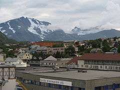 Part of Skjervøy village
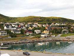 Part of Skjervøy village
 Old photo of Skjervøy Church
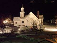
References
- "Navn på steder og personer: Innbyggjarnamn" (in Norwegian). Språkrådet.
- "Forskrift om målvedtak i kommunar og fylkeskommunar" (in Norwegian). Lovdata.no.
- Statistisk sentralbyrå (2020). "Table: 06913: Population 1 January and population changes during the calendar year (M)" (in Norwegian).
- Statistisk sentralbyrå (2020). "09280: Area of land and fresh water (km²) (M)" (in Norwegian).
- Jukvam, Dag (1999). "Historisk oversikt over endringer i kommune- og fylkesinndelingen" (PDF) (in Norwegian). Statistisk sentralbyrå.
- Mæhlum, Lars, ed. (2019-12-24). "Troms og Finnmark". Store norske leksikon (in Norwegian). Kunnskapsforlaget. Retrieved 2019-12-26.
- Rygh, Oluf (1911). Norske gaardnavne: Troms amt (in Norwegian) (17 ed.). Kristiania, Norge: W. C. Fabritius & sønners bogtrikkeri. p. 176.
- "Civic heraldry of Norway - Norske Kommunevåpen". Heraldry of the World. Retrieved 2018-08-04.
- Hansen, Tore, ed. (2016-05-12). "kommunestyre". Store norske leksikon (in Norwegian). Kunnskapsforlaget. Retrieved 2018-08-02.
- "Tall for Norge: Kommunestyrevalg 2019 - Troms og Finnmark". Valg Direktoratet. Retrieved 2019-10-26.
- "Table: 04813: Members of the local councils, by party/electoral list at the Municipal Council election (M)" (in Norwegian). Statistics Norway.
- "Tall for Norge: Kommunestyrevalg 2011 - Troms Romsa". Valg Direktoratet. Retrieved 2019-10-26.
- "Kommunestyrevalget 1995" (PDF) (in Norwegian). Oslo-Kongsvinger: Statistisk sentralbyrå. 1996. Retrieved 2020-03-18.
- "Kommunestyrevalget 1991" (PDF) (in Norwegian). Oslo-Kongsvinger: Statistisk sentralbyrå. 1993. Retrieved 2020-03-18.
- "Kommunestyrevalget 1987" (PDF) (in Norwegian). Oslo-Kongsvinger: Statistisk sentralbyrå. 1988. Retrieved 2020-03-18.
- "Kommunestyrevalget 1983" (PDF) (in Norwegian). Oslo-Kongsvinger: Statistisk sentralbyrå. 1984. Retrieved 2020-03-18.
- "Kommunestyrevalget 1979" (PDF) (in Norwegian). Oslo: Statistisk sentralbyrå. 1979. Retrieved 2020-03-18.
- "Kommunevalgene 1975" (PDF) (in Norwegian). Oslo: Statistisk sentralbyrå. 1977. Retrieved 2020-03-18.
- "Kommunevalgene 1972" (PDF) (in Norwegian). Oslo: Statistisk sentralbyrå. 1973. Retrieved 2020-03-18.
- "Kommunevalgene 1967" (PDF) (in Norwegian). Oslo: Statistisk sentralbyrå. 1967. Retrieved 2020-03-18.
- "Kommunevalgene 1963" (PDF) (in Norwegian). Oslo: Statistisk sentralbyrå. 1964. Retrieved 2020-03-18.
- "Kommunevalgene og Ordførervalgene 1959" (PDF) (in Norwegian). Oslo: Statistisk sentralbyrå. 1960. Retrieved 2020-03-18.
- "Kommunevalgene og Ordførervalgene 1955" (PDF) (in Norwegian). Oslo: Statistisk sentralbyrå. 1957. Retrieved 2020-03-18.
- "Kommunevalgene og Ordførervalgene 1951" (PDF) (in Norwegian). Oslo: Statistisk sentralbyrå. 1952. Retrieved 2020-03-18.
- "Kommunevalgene og Ordførervalgene 1947" (PDF) (in Norwegian). Oslo: Statistisk sentralbyrå. 1948. Retrieved 2020-03-18.
- "Kommunevalgene og Ordførervalgene 1945" (PDF) (in Norwegian). Oslo: Statistisk sentralbyrå. 1947. Retrieved 2020-03-18.
- "Kommunevalgene og Ordførervalgene 1937" (PDF) (in Norwegian). Oslo: Statistisk sentralbyrå. 1938. Retrieved 2020-03-18.
- Statistisk sentralbyrå (1 January 2012). "Urban settlements. Population and area, by municipality". Archived from the original on 13 November 2012.
- "eKlima Web Portal". Norwegian Meteorological Institute. Archived from the original on 2004-06-14.
External links
| Wikivoyage has a travel guide for Troms. |
| Wikimedia Commons has media related to Skjervøy. |
| Look up skjervøy in Wiktionary, the free dictionary. |
- Municipal fact sheet from Statistics Norway (in Norwegian)
- 41 kg cod caught on fishing rod April 2010 (with pictures) (in Norwegian)
- Visit Tromso January 2018 list of Express Boats and Ferry service for Tromso.
- Boreal Transport Nord Nord AS January 2018 list for ferry routes by ferry operator for Troms county
Troms og Finnmark county, Norway | |||||||||||||||||||||||
|---|---|---|---|---|---|---|---|---|---|---|---|---|---|---|---|---|---|---|---|---|---|---|---|
 |
|   | |||||||||||||||||||||
||
| Authority control |
|
|---|