Bardu
Bardu (Northern Sami: Bearddu suohkan, Kven: Perttulan komuuni) is a municipality in Troms og Finnmark county, Norway. The administrative centre of the municipality is the village of Setermoen, the largest urban area in the municipality.
Bardu kommune Bearddu suohkan Perttulan komuuni | |
|---|---|
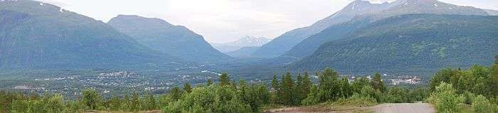 Panorama of the village of Setermoen | |
 Coat of arms  Troms og Finnmark within Norway | |
 Bardu within Troms og Finnmark | |
| Coordinates: 68°51′51″N 18°21′10″E | |
| Country | Norway |
| County | Troms og Finnmark |
| District | Midt-Troms |
| Established | 1854 |
| Administrative centre | Setermoen |
| Government | |
| • Mayor (2015) | Toralf Heimdal (Sp) |
| Area | |
| • Total | 2,703.89 km2 (1,043.98 sq mi) |
| • Land | 2,513.60 km2 (970.51 sq mi) |
| • Water | 190.29 km2 (73.47 sq mi) 7% |
| Area rank | 18 in Norway |
| Population (2020) | |
| • Total | 4,005 |
| • Rank | 203 in Norway |
| • Density | 1.6/km2 (4/sq mi) |
| • Change (10 years) | 1.4% |
| Demonym(s) | Bardudøl[1] |
| Time zone | UTC+01:00 (CET) |
| • Summer (DST) | UTC+02:00 (CEST) |
| ISO 3166 code | NO-5416 |
| Official language form | Neutral[2] |
| Website | bardu |
The 2,704-square-kilometre (1,044 sq mi) municipality is the 18th largest by area out of the 356 municipalities in Norway. Bardu is the 203rd most populous municipality in Norway with a population of 4,005. The municipality's population density is 1.6 inhabitants per square kilometre (4.1/sq mi) and its population has increased by 1.4% over the last decade.[3][4]
Norway's largest military garrison is located at Setermoen. The military is the municipality's largest employer and more than 1,000 young soldiers perform their duty service here each year. The world's most northern zoo, Polar Park, is located in the southern part of the municipality.
General information
The municipality of Bardodalen was established in 1854 when the eastern part of the old Ibestad Municipality was separated to form the new municipality. The initial population of the new municipality was 757. The municipal borders have not changed since then, although the name was later changed to Bardu.[5]
On 1 January 2020, the municipality became part of the newly formed Troms og Finnmark county. Previously, it had been part of the old Troms county.[6]
Name
Bardu is a Norwegianized form of the Sámi name Beardu. The meaning of the Sámi name is probably "long and steep mountain side". Prior to 1889, the municipality was called "Bardodalen" which meant "the valley/dale of Bardo". From 1889 until 1908, the name was written "Bardo". Since 1909, it has been spelled "Bardu".[7]
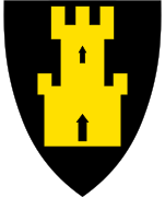
Coat of arms
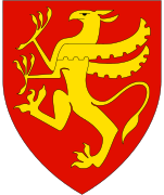
The coat of arms is from modern times; they were granted on 6 June 1980. The arms show a black wolverine on a gold background. It was chosen as a symbol for the large forests and the rich wildlife in the municipality.[8] The rock speedwell (Veronica fruticans) is the municipal flower.
Churches
The Church of Norway has one parish (sokn) within the municipality of Bardu. It is part of the Indre Troms prosti (deanery) in the Diocese of Nord-Hålogaland.
| Parish (Sokn) | Church Name | Location of the Church | Year Built |
|---|---|---|---|
| Bardu | Bardu Church | Setermoen | 1829 |
| Nedre Bardu Chapel | Brandmoen | 1981 | |
| Øvre Bardu Chapel | Sørdalen | 1971 | |
| Salangsdalen Chapel | Salangsdalen | 1981 |
Government
All municipalities in Norway, including Bardu, are responsible for primary education (through 10th grade), outpatient health services, senior citizen services, unemployment and other social services, zoning, economic development, and municipal roads. The municipality is governed by a municipal council of elected representatives, which in turn elect a mayor.[9] The municipality falls under the Senja District Court and the Hålogaland Court of Appeal.
Municipal council
The municipal council (Kommunestyre) of Bardu is made up of 19 representatives that are elected to four year terms. The party breakdown of the council is as follows:
| Party Name (in Norwegian) | Number of representatives | |
|---|---|---|
| Labour Party (Arbeiderpartiet) | 4 | |
| Conservative Party (Høyre) | 2 | |
| Centre Party (Senterpartiet) | 12 | |
| Liberal Party (Venstre) | 1 | |
| Total number of members: | 19 | |
| Party Name (in Norwegian) | Number of representatives | |
|---|---|---|
| Labour Party (Arbeiderpartiet) | 7 | |
| Progress Party (Fremskrittspartiet) | 1 | |
| Conservative Party (Høyre) | 4 | |
| Centre Party (Senterpartiet) | 6 | |
| Liberal Party (Venstre) | 1 | |
| Total number of members: | 19 | |
| Party Name (in Norwegian) | Number of representatives | |
|---|---|---|
| Labour Party (Arbeiderpartiet) | 13 | |
| Progress Party (Fremskrittspartiet) | 1 | |
| Conservative Party (Høyre) | 7 | |
| Centre Party (Senterpartiet) | 3 | |
| Liberal Party (Venstre) | 1 | |
| Total number of members: | 25 | |
| Party Name (in Norwegian) | Number of representatives | |
|---|---|---|
| Labour Party (Arbeiderpartiet) | 7 | |
| Progress Party (Fremskrittspartiet) | 3 | |
| Conservative Party (Høyre) | 4 | |
| Centre Party (Senterpartiet) | 9 | |
| Socialist Left Party (Sosialistisk Venstreparti) | 1 | |
| Liberal Party (Venstre) | 1 | |
| Total number of members: | 25 | |
| Party Name (in Norwegian) | Number of representatives | |
|---|---|---|
| Labour Party (Arbeiderpartiet) | 8 | |
| Progress Party (Fremskrittspartiet) | 2 | |
| Conservative Party (Høyre) | 4 | |
| Centre Party (Senterpartiet) | 7 | |
| Socialist Left Party (Sosialistisk Venstreparti) | 2 | |
| Liberal Party (Venstre) | 1 | |
| Bardu Independent Election List (Bardu Uavhengige Folkevalgte) | 1 | |
| Total number of members: | 25 | |
| Party Name (in Norwegian) | Number of representatives | |
|---|---|---|
| Labour Party (Arbeiderpartiet) | 8 | |
| Conservative Party (Høyre) | 8 | |
| Centre Party (Senterpartiet) | 6 | |
| Socialist Left Party (Sosialistisk Venstreparti) | 1 | |
| Liberal Party (Venstre) | 1 | |
| Bardu local list (Bardu bygdeliste) | 1 | |
| Total number of members: | 25 | |
| Party Name (in Norwegian) | Number of representatives | |
|---|---|---|
| Labour Party (Arbeiderpartiet) | 9 | |
| Conservative Party (Høyre) | 8 | |
| Centre Party (Senterpartiet) | 6 | |
| Socialist Left Party (Sosialistisk Venstreparti) | 1 | |
| Bardu local list (Bardu Bygdeliste) | 1 | |
| Total number of members: | 25 | |
| Party Name (in Norwegian) | Number of representatives | |
|---|---|---|
| Labour Party (Arbeiderpartiet) | 8 | |
| Progress Party (Fremskrittspartiet) | 1 | |
| Conservative Party (Høyre) | 8 | |
| Centre Party (Senterpartiet) | 6 | |
| Socialist Left Party (Sosialistisk Venstreparti) | 2 | |
| Total number of members: | 25 | |
| Party Name (in Norwegian) | Number of representatives | |
|---|---|---|
| Labour Party (Arbeiderpartiet) | 10 | |
| Conservative Party (Høyre) | 9 | |
| Centre Party (Senterpartiet) | 5 | |
| Socialist Left Party (Sosialistisk Venstreparti) | 1 | |
| Total number of members: | 25 | |
| Party Name (in Norwegian) | Number of representatives | |
|---|---|---|
| Labour Party (Arbeiderpartiet) | 11 | |
| Conservative Party (Høyre) | 5 | |
| Christian Democratic Party (Kristelig Folkeparti) | 1 | |
| Centre Party (Senterpartiet) | 7 | |
| Socialist Left Party (Sosialistisk Venstreparti) | 1 | |
| Total number of members: | 25 | |
| Party Name (in Norwegian) | Number of representatives | |
|---|---|---|
| Labour Party (Arbeiderpartiet) | 10 | |
| Conservative Party (Høyre) | 7 | |
| Christian Democratic Party (Kristelig Folkeparti) | 1 | |
| Centre Party (Senterpartiet) | 6 | |
| Socialist Left Party (Sosialistisk Venstreparti) | 1 | |
| Total number of members: | 25 | |
| Party Name (in Norwegian) | Number of representatives | |
|---|---|---|
| Labour Party (Arbeiderpartiet) | 12 | |
| Conservative Party (Høyre) | 5 | |
| Christian Democratic Party (Kristelig Folkeparti) | 1 | |
| Centre Party (Senterpartiet) | 6 | |
| Socialist Left Party (Sosialistisk Venstreparti) | 1 | |
| Total number of members: | 25 | |
| Party Name (in Norwegian) | Number of representatives | |
|---|---|---|
| Labour Party (Arbeiderpartiet) | 11 | |
| Conservative Party (Høyre) | 2 | |
| Centre Party (Senterpartiet) | 7 | |
| Liberal Party (Venstre) | 1 | |
| Total number of members: | 21 | |
| Party Name (in Norwegian) | Number of representatives | |
|---|---|---|
| Labour Party (Arbeiderpartiet) | 11 | |
| Conservative Party (Høyre) | 3 | |
| Centre Party (Senterpartiet) | 6 | |
| Liberal Party (Venstre) | 1 | |
| Total number of members: | 21 | |
| Party Name (in Norwegian) | Number of representatives | |
|---|---|---|
| Labour Party (Arbeiderpartiet) | 12 | |
| Conservative Party (Høyre) | 3 | |
| Centre Party (Senterpartiet) | 5 | |
| Liberal Party (Venstre) | 1 | |
| Total number of members: | 21 | |
| Party Name (in Norwegian) | Number of representatives | |
|---|---|---|
| Labour Party (Arbeiderpartiet) | 12 | |
| Conservative Party (Høyre) | 2 | |
| Centre Party (Senterpartiet) | 5 | |
| Liberal Party (Venstre) | 1 | |
| Local List(s) (Lokale lister) | 1 | |
| Total number of members: | 21 | |
| Party Name (in Norwegian) | Number of representatives | |
|---|---|---|
| Labour Party (Arbeiderpartiet) | 11 | |
| Conservative Party (Høyre) | 2 | |
| Joint List(s) of Non-Socialist Parties (Borgerlige Felleslister) | 8 | |
| Total number of members: | 21 | |
| Party Name (in Norwegian) | Number of representatives | |
|---|---|---|
| Labour Party (Arbeiderpartiet) | 7 | |
| Joint List(s) of Non-Socialist Parties (Borgerlige Felleslister) | 9 | |
| Total number of members: | 16 | |
| Party Name (in Norwegian) | Number of representatives | |
|---|---|---|
| Labour Party (Arbeiderpartiet) | 8 | |
| Joint List(s) of Non-Socialist Parties (Borgerlige Felleslister) | 8 | |
| Total number of members: | 16 | |
| Party Name (in Norwegian) | Number of representatives | |
|---|---|---|
| Labour Party (Arbeiderpartiet) | 9 | |
| Local List(s) (Lokale lister) | 7 | |
| Total number of members: | 16 | |
| Party Name (in Norwegian) | Number of representatives | |
|---|---|---|
| Labour Party (Arbeiderpartiet) | 7 | |
| Joint List(s) of Non-Socialist Parties (Borgerlige Felleslister) | 9 | |
| Total number of members: | 16 | |
Geography
Bardu borders the municipalities of Lavangen and Salangen to the west, Målselv to the north, Narvik (in Nordland county) to the south, and Sweden to the east. The Barduelva river runs through the municipality from south to north along the Bardudalen valley. The Salangsdalen valley is located along the western part of the municipality. The largest lake in the county, Altevatnet, is located in the eastern part of the municipality, near the smaller lakes Geavdnjajávri and Leinavatn. These lakes lie in and near Rohkunborri National Park.
Climate
Bardu, although not far from the coast, is known for its cold winters compared to the coastal areas. This is caused by mountains usually blocking the milder, coastal air from reaching the Bardu valley. In summer, however, it is usually warmer than the coastal areas.
| Climate data for Setermoen | |||||||||||||
|---|---|---|---|---|---|---|---|---|---|---|---|---|---|
| Month | Jan | Feb | Mar | Apr | May | Jun | Jul | Aug | Sep | Oct | Nov | Dec | Year |
| Daily mean °C (°F) | −10.3 (13.5) |
−8.8 (16.2) |
−5.3 (22.5) |
−0.2 (31.6) |
5.6 (42.1) |
10.6 (51.1) |
13.1 (55.6) |
11.5 (52.7) |
6.4 (43.5) |
1.2 (34.2) |
−5.2 (22.6) |
−8.8 (16.2) |
0.8 (33.4) |
| Average precipitation mm (inches) | 73 (2.9) |
67 (2.6) |
45 (1.8) |
42 (1.7) |
35 (1.4) |
49 (1.9) |
69 (2.7) |
79 (3.1) |
79 (3.1) |
106 (4.2) |
75 (3.0) |
78 (3.1) |
797 (31.4) |
| Average precipitation days (≥ 1 mm) | 11.2 | 11.8 | 9.6 | 8.8 | 8.0 | 9.7 | 12.4 | 13.2 | 13.7 | 13.9 | 11.8 | 12.6 | 136.7 |
| Source: Norwegian Meteorological Institute[28] | |||||||||||||
Media gallery
.jpg)
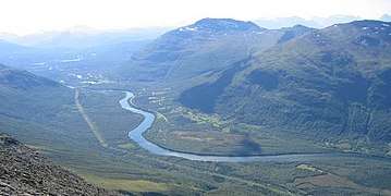 The Bardu valley and river seen from Istind in the direction of Setermoen
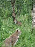 Lynx at the Polar Park in Bardu.
Notable residents
- Fred Børre Lundberg, internationally renowned Nordic combined performers
References
- "Navn på steder og personer: Innbyggjarnamn" (in Norwegian). Språkrådet.
- "Forskrift om målvedtak i kommunar og fylkeskommunar" (in Norwegian). Lovdata.no.
- Statistisk sentralbyrå (2020). "Table: 06913: Population 1 January and population changes during the calendar year (M)" (in Norwegian).
- Statistisk sentralbyrå. "09280: Area of land and fresh water (km²) (M)" (in Norwegian).
- Jukvam, Dag (1999). "Historisk oversikt over endringer i kommune- og fylkesinndelingen" (PDF) (in Norwegian). Statistisk sentralbyrå.
- Mæhlum, Lars, ed. (24 December 2019). "Troms og Finnmark". Store norske leksikon (in Norwegian). Kunnskapsforlaget. Retrieved 26 December 2019.
- Store norske leksikon. "Bardu" (in Norwegian). Retrieved 28 September 2012.
- "Civic heraldry of Norway - Norske Kommunevåpen". Heraldry of the World. Retrieved 19 August 2018.
- Hansen, Tore, ed. (12 May 2016). "kommunestyre". Store norske leksikon (in Norwegian). Kunnskapsforlaget. Retrieved 19 August 2018.
- "Tall for Norge: Kommunestyrevalg 2019 - Troms og Finnmark". Valg Direktoratet. Retrieved 24 October 2019.
- "Table: 04813: Members of the local councils, by party/electoral list at the Municipal Council election (M)" (in Norwegian). Statistics Norway.
- "Tall for Norge: Kommunestyrevalg 2011 - Troms Romsa". Valg Direktoratet. Retrieved 24 October 2019.
- "Kommunestyrevalget 1995" (PDF) (in Norwegian). Oslo-Kongsvinger: Statistisk sentralbyrå. 1996. Retrieved 18 March 2020.
- "Kommunestyrevalget 1991" (PDF) (in Norwegian). Oslo-Kongsvinger: Statistisk sentralbyrå. 1993. Retrieved 18 March 2020.
- "Kommunestyrevalget 1987" (PDF) (in Norwegian). Oslo-Kongsvinger: Statistisk sentralbyrå. 1988. Retrieved 18 March 2020.
- "Kommunestyrevalget 1983" (PDF) (in Norwegian). Oslo-Kongsvinger: Statistisk sentralbyrå. 1984. Retrieved 18 March 2020.
- "Kommunestyrevalget 1979" (PDF) (in Norwegian). Oslo: Statistisk sentralbyrå. 1979. Retrieved 18 March 2020.
- "Kommunevalgene 1975" (PDF) (in Norwegian). Oslo: Statistisk sentralbyrå. 1977. Retrieved 18 March 2020.
- "Kommunevalgene 1972" (PDF) (in Norwegian). Oslo: Statistisk sentralbyrå. 1973. Retrieved 18 March 2020.
- "Kommunevalgene 1967" (PDF) (in Norwegian). Oslo: Statistisk sentralbyrå. 1967. Retrieved 18 March 2020.
- "Kommunevalgene 1963" (PDF) (in Norwegian). Oslo: Statistisk sentralbyrå. 1964. Retrieved 18 March 2020.
- "Kommunevalgene og Ordførervalgene 1959" (PDF) (in Norwegian). Oslo: Statistisk sentralbyrå. 1960. Retrieved 18 March 2020.
- "Kommunevalgene og Ordførervalgene 1955" (PDF) (in Norwegian). Oslo: Statistisk sentralbyrå. 1957. Retrieved 18 March 2020.
- "Kommunevalgene og Ordførervalgene 1951" (PDF) (in Norwegian). Oslo: Statistisk sentralbyrå. 1952. Retrieved 18 March 2020.
- "Kommunevalgene og Ordførervalgene 1947" (PDF) (in Norwegian). Oslo: Statistisk sentralbyrå. 1948. Retrieved 18 March 2020.
- "Kommunevalgene og Ordførervalgene 1945" (PDF) (in Norwegian). Oslo: Statistisk sentralbyrå. 1947. Retrieved 18 March 2020.
- "Kommunevalgene og Ordførervalgene 1937" (PDF) (in Norwegian). Oslo: Statistisk sentralbyrå. 1938. Retrieved 18 March 2020.
- "eKlima Web Portal". Norwegian Meteorological Institute. Archived from the original on 14 June 2004.
External links
| Wikimedia Commons has media related to Bardu. |
| Look up bardu in Wiktionary, the free dictionary. |
- Municipal fact sheet from Statistics Norway

- http://www.polarzoo.no
Troms og Finnmark county, Norway | |||||||||||||||||||||||
|---|---|---|---|---|---|---|---|---|---|---|---|---|---|---|---|---|---|---|---|---|---|---|---|
 |
|   | |||||||||||||||||||||
||
| Authority control |
|
|---|