Arnøya
Arnøya (Norwegian) or Árdni (Northern Sami) is the 15th largest island in Norway. The 276-square-kilometre (107 sq mi) island is located in Skjervøy Municipality in Troms og Finnmark county. The highest peak is the 1,168-metre (3,832 ft) tall mountain Arnøyhøgda. There are regular ferry connections to the island from the nearby islands of Laukøya and Kågen, but there are no road connections to the island.[1] Arnøy Church is located on the southern shore of the island.
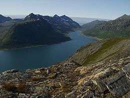 Langfjorden, Arnøya island | |
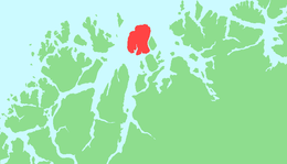 | |
 Arnøya Location of the island  Arnøya Arnøya (Norway) | |
| Geography | |
|---|---|
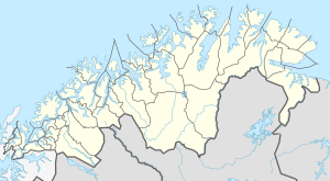
| Location | Troms og Finnmark, Norway |
| Coordinates | 70.0634°N 20.7366°E |
| Area | 276 km2 (107 sq mi) |
| Area rank | 15th in Norway |
| Length | 23.6 km (14.66 mi) |
| Width | 14.4 km (8.95 mi) |
| Coastline | 91 km (56.5 mi) |
| Highest elevation | 1,168 m (3,832 ft) |
| Highest point | Arnøyhøgda |
| Administration | |
Norway | |
| County | Troms og Finnmark |
| Municipality | Skjervøy Municipality |
| Demographics | |
| Population | 366 (2010) |
| Pop. density | 1.3/km2 (3.4/sq mi) |
The villages of Årviksand, Arnøyhamn, Akkarvik, and Lauksletta are located on the island. The island of Laukøya is located just to the east, Skjervøya and Kågen are to the southeast, and Vannøya is to the west. The Ullsfjorden lies to the west, the Lyngen fjord lies to the south, the Kvænangen fjord lies to the east, and the Norwegian Sea lies to the north.
The Lyngen Alps are located south of Arnøya and they are a popular place for extreme skiers.[2] Arnøya is also becoming a popular skiing destination.[3]
References
- Store norske leksikon. "Arnøy – øy i Skjervøy" (in Norwegian). Retrieved 2010-04-11.
- "Ski touring in the Lyngen Alps, Norway". Retrieved 2018-08-03.
- "Activities - Akkarvik". Retrieved 2018-08-03.