Shrewsbury, New Jersey
Shrewsbury is a borough in Monmouth County, New Jersey, USA. As of the 2010 United States Census, the borough's population was 3,809,[9][10][11] reflecting an increase of 219 (+6.1%) from the 3,590 counted in the 2000 Census, which had in turn increased by 494 (+16.0%) from the 3,096 counted in the 1990 Census.[20]
Shrewsbury, New Jersey | |
|---|---|
| Borough of Shrewsbury | |
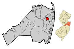 Map of Shrewsbury in Monmouth County. Inset: Location of Monmouth County highlighted in the State of New Jersey. | |
 Census Bureau map of Shrewsbury, New Jersey | |
| Coordinates: 40.326064°N 74.059667°W[1][2] | |
| Country | |
| State | |
| County | Monmouth |
| Incorporated | May 11, 1926 |
| Named for | Shrewsbury, England |
| Government | |
| • Type | Borough |
| • Body | Borough Council |
| • Mayor | Erik Anderson (R, term ends December 31, 2022)[4][5] |
| • Administrator | Maureen L. Muttie[6] |
| • Municipal clerk | Maureen L. Muttie[7] |
| Area | |
| • Total | 2.200 sq mi (5.697 km2) |
| • Land | 2.168 sq mi (5.614 km2) |
| • Water | 0.032 sq mi (0.083 km2) 1.45% |
| Area rank | 394th of 566 in state 27th of 53 in county[1] |
| Elevation | 39 ft (12 m) |
| Population | |
| • Total | 3,809 |
| • Estimate (2019)[12] | 4,053 |
| • Rank | 423rd of 566 in state 38th of 53 in county[13] |
| • Density | 1,757.2/sq mi (678.5/km2) |
| • Density rank | 307th of 566 in state 38th of 53 in county[13] |
| Time zone | UTC−05:00 (Eastern (EST)) |
| • Summer (DST) | UTC−04:00 (Eastern (EDT)) |
| ZIP Code | |
| Area code(s) | 732[16] |
| FIPS code | 3402567350[1][17][18] |
| GNIS feature ID | 0885395[1][19] |
| Website | www |
Shrewsbury was formed as a borough by an act of the New Jersey Legislature on March 22, 1926, from portions of Shrewsbury Township, based on the results of a referendum held on May 11, 1926.[21] The borough's name comes from Shrewsbury, England.[22]
Geography

According to the United States Census Bureau, Shrewsbury borough had a total area of 2.200 square miles (5.697 km2), including 2.168 square miles (5.614 km2) of land and 0.032 square miles (0.083 km2) of water (1.45%).[1][2]
The borough borders the Monmouth County municipalities of Eatontown, Little Silver, Oceanport, Red Bank, Shrewsbury Township and Tinton Falls.[23][24][25]
Shrewsbury Borough prior to 1926 was a part of Shrewsbury Township, which had originally encompassed most of Monmouth and Ocean County, New Jersey counties, including several of the other municipalities nearby, until finally shrinking down to under one square mile.[21][26]
Demographics

| Historical population | |||
|---|---|---|---|
| Census | Pop. | %± | |
| 1930 | 857 | — | |
| 1940 | 1,058 | 23.5% | |
| 1950 | 1,613 | 52.5% | |
| 1960 | 3,222 | 99.8% | |
| 1970 | 3,315 | 2.9% | |
| 1980 | 2,962 | −10.6% | |
| 1990 | 3,096 | 4.5% | |
| 2000 | 3,590 | 16.0% | |
| 2010 | 3,809 | 6.1% | |
| Est. 2019 | 4,053 | [12][27] | 6.4% |
| Population sources: 1930[28] 1930–1990[29] 2000[30][31] 2010[9][10][11] | |||
Census 2010
The 2010 United States Census counted 3,809 people, 1,261 households, and 1,026.454 families in the borough. The population density was 1,757.2 per square mile (678.5/km2). There were 1,310 housing units at an average density of 604.4 per square mile (233.4/km2). The racial makeup of the borough was 95.62% (3,642) White, 0.66% (25) Black or African American, 0.11% (4) Native American, 2.13% (81) Asian, 0.03% (1) Pacific Islander, 0.58% (22) from other races, and 0.89% (34) from two or more races. Hispanic or Latino of any race were 2.49% (95) of the population.[9]
The 1,261 households accounted 40.7% with children under the age of 18 living with them; 71.5% were married couples living together; 8.2% had a female householder with no husband present, and 18.6% were non-families. Of all households, 16.5% were made up of individuals, and 9.2% had someone living alone who was 65 years of age or older. The average household size was 2.87 and the average family size was 3.24.[9]
In the borough, the population age was spread out with 27.0% under the age of 18, 5.0% from 18 to 24, 19.2% from 25 to 44, 31.2% from 45 to 64, and 17.6% who were 65 years of age or older. The median age was 44.3 years. For every 100 females, the population had 87.7 males. For every 100 females ages 18 and older there were 84.7 males.[9]
The Census Bureau's 2006–2010 American Community Survey showed that (in 2010 inflation-adjusted dollars) median household income was $111,648 (with a margin of error of +/- $15,595) and the median family income was $124,091 (+/- $10,340). Males had a median income of $111,645 (+/- $13,085) versus $54,313 (+/- $9,453) for females. The per capita income for the borough was $47,698 (+/- $5,936). About none of families and 1.1% of the population were below the poverty line, including none of those under age 18 and 4.3% of those age 65 or over.[32]
Census 2000

As of the 2000 United States Census[17] there were 3,590 people, 1,207 households, and 1,016 families residing in the borough. The population density was 1,627.1 people per square mile (627.2/km2). There were 1,223 housing units at an average density of 554.3 per square mile (213.7/km2). The racial makeup of the borough was 96.60% White, 0.53% African American, 1.67% Asian, 0.36% from other races, and 0.84% from two or more races. Hispanic or Latino of any race were 1.92% of the population.[30][31]
There were 1,207 households, out of which 46.0% had children under the age of 18 living with them, 74.6% were married couples living together, 7.2% had a female householder with no husband present, and 15.8% were non-families. 12.9% of all households were made up of individuals, and 6.9% had someone living alone who was 65 years of age or older. The average household size was 2.96 and the average family size was 3.27.[30][31]
In the borough the population was spread out, with 30.8% under the age of 18, 4.0% from 18 to 24, 28.1% from 25 to 44, 25.1% from 45 to 64, and 12.0% who were 65 years of age or older. The median age was 38 years. For every 100 females, there were 98.5 males. For every 100 females age 18 and over, there were 93.2 males.[30][31]
The median income for a household in the borough was $86,911, and the median income for a family was $92,719. Males had a median income of $85,875 versus $37,554 for females. The per capita income for the borough was $38,218. None of the families and 1.0% of the population were living below the poverty line, including no under 18 and 3.0% of those over 64.[30][31]
Government
Local government
Shrewsbury is governed under the Borough form of New Jersey municipal government, which is used in 218 of 565 municipalities statewide, making it the most common form of government in New Jersey.[33] The governing body is comprised of a Mayor and a Borough Council, with all positions elected at-large on a partisan basis as part of the November general election. A Mayor is elected directly by the voters to a four-year term of office. The Borough Council is comprised of six members elected to serve three-year terms on a staggered basis, with two seats coming up for election each year in a three-year cycle.[3] The Borough form of government used by Shrewsbury is a "weak mayor / strong council" government in which council members act as the legislative body with the mayor presiding at meetings and voting only in the event of a tie. The mayor can veto ordinances subject to an override by a two-thirds majority vote of the council. The mayor makes committee and liaison assignments for council members, and most appointments are made by the mayor with the advice and consent of the council.[34][35]
As of 2020, the mayor of Shrewsbury Borough is Republican Erik Anderson, whose term of office ends December 31, 2022. Members of the Borough Council are Council President Kimberly Doran Eulner (R, 2021), Deidre M. DerAsadourian (R, 2022), Donald J. Eddy (R, 2021), Jason Sena (R, 2022), Jeff DeSalvo (R, 2021) and Brendan Gilmartin (R, 2020).[4][36][37][38][39][40]
In February 2016, the Borough Council selected Erik Anderson to fill the seat expiring in December 2017 that had been held by William E. Dodge until his resignation earlier that month.[41][42]
Federal, state and county representation
Shrewsbury Borough is located in the 4th Congressional District[43] and is part of New Jersey's 11th state legislative district.[10][44][45] Prior to the 2011 reapportionment following the 2010 Census, Shrewsbury Borough had been in the 12th state legislative district.[46] Prior to the 2010 Census, Shrewsbury Borough had been part of the 12th Congressional District, a change made by the New Jersey Redistricting Commission that took effect in January 2013, based on the results of the November 2012 general elections.[46]
For the 116th United States Congress, New Jersey's Fourth Congressional District is represented by Chris Smith (R, Hamilton Township).[47][48] New Jersey is represented in the United States Senate by Democrats Cory Booker (Newark, term ends 2021)[49] and Bob Menendez (Paramus, term ends 2025).[50][51]
For the 2018–2019 session (Senate, General Assembly), the 11th Legislative District of the New Jersey Legislature is represented in the State Senate by Vin Gopal (D, Long Branch) and in the General Assembly by Joann Downey (D, Freehold Township) and Eric Houghtaling (D, Neptune Township).[52][53]
Monmouth County is governed by a Board of Chosen Freeholders consisting of five members who are elected at-large to serve three year terms of office on a staggered basis, with either one or two seats up for election each year as part of the November general election. At an annual reorganization meeting held in the beginning of January, the board selects one of its members to serve as Director and another as Deputy Director.[54] As of 2020, Monmouth County's Freeholders are Freeholder Director Thomas A. Arnone (R, Neptune City, term as freeholder ends December 31, 2022; term as freeholder director ends 2021),[55] Freeholder Deputy Director Susan M. Kiley (R, Hazlet Township, term as freeholder ends December 31, 2021; term as deputy freeholder director ends 2021),[56] Lillian G. Burry (R, Colts Neck Township, 2020),[57] Nick DiRocco (R, Wall Township, 2022),[58] and Patrick G. Impreveduto (R, Holmdel Township, 2020)[59].
Constitutional officers elected on a countywide basis are County clerk Christine Giordano Hanlon (R, 2020; Ocean Township),[60][61] Sheriff Shaun Golden (R, 2022; Howell Township),[62][63] and Surrogate Rosemarie D. Peters (R, 2021; Middletown Township).[64][65]
Politics
As of March 23, 2011, there were a total of 2,844 registered voters in Shrewsbury, of which 650 (22.9%) were registered as Democrats, 863 (30.3%) were registered as Republicans and 1,330 (46.8%) were registered as Unaffiliated. There as one voter registered to another party.[66]
In the 2012 presidential election, Republican Mitt Romney received 57.2% of the vote (1,205 cast), ahead of Democrat Barack Obama with 41.6% (876 votes), and other candidates with 1.3% (27 votes), among the 2,120 ballots cast by the borough's 2,935 registered voters (12 ballots were spoiled), for a turnout of 72.2%.[67][68] In the 2008 presidential election, Republican John McCain received 54.5% of the vote (1,248 cast), ahead of Democrat Barack Obama with 42.8% (980 votes) and other candidates with 1.3% (30 votes), among the 2,291 ballots cast by the borough's 2,944 registered voters, for a turnout of 77.8%.[69] In the 2004 presidential election, Republican George W. Bush received 58.9% of the vote (1,305 ballots cast), outpolling Democrat John Kerry with 40.2% (891 votes) and other candidates with 0.6% (18 votes), among the 2,217 ballots cast by the township's 2,834 registered voters, for a turnout percentage of 78.2.[70]
In the 2013 gubernatorial election, Republican Chris Christie received 72.5% of the vote (955 cast), ahead of Democrat Barbara Buono with 26.4% (348 votes), and other candidates with 1.1% (14 votes), among the 1,330 ballots cast by the borough's 3,000 registered voters (13 ballots were spoiled), for a turnout of 44.3%.[71][72] In the 2009 gubernatorial election, Republican Chris Christie received 65.3% of the vote (1,063 ballots cast), ahead of Democrat Jon Corzine with 24.8% (404 votes), Independent Chris Daggett with 8.3% (135 votes) and other candidates with 0.9% (14 votes), among the 1,628 ballots cast by the borough's 2,885 registered voters, yielding a 56.4% turnout.[73]
Education

The Shrewsbury Borough School District serves public school students ranging from pre-kindergarten through eighth grade at the Shrewsbury Borough School.[74][75] As of the 2018–19 school year, the district, comprised of one school, had an enrollment of 479 students and 50.3 classroom teachers (on an FTE basis), for a student–teacher ratio of 9.5:1.[76] The school features three homerooms per grade, with special classes that include physical education, art, music, computers, and for language, Spanish.
For ninth through twelfth grades, public school students attend Red Bank Regional High School, which serves students from the boroughs of Little Silver, Red Bank and Shrewsbury, along with students in the district's academy programs from other communities who are eligible to attend on a tuition basis.[77][78] Students from other Monmouth County municipalities are eligible to attend the high school for its performing arts program, with admission on a competitive basis.[79] The borough has two elected representatives on the nine-member Board of Education.[80] As of the 2018–19 school year, the high school had an enrollment of 1,208 students and 119.6 classroom teachers (on an FTE basis), for a student–teacher ratio of 10.1:1.[81]
Private school options include Christian Brothers Academy or Red Bank Catholic High School, the local Catholic schools, operated by the Roman Catholic Diocese of Trenton.[82]
Transportation
_at_Monmouth_County_Route_13A_(Sycamore_Avenue)_in_Shrewsbury%2C_Monmouth_County%2C_New_Jersey.jpg)
Roads and highways
As of May 2010, the borough had a total of 21.50 miles (34.60 km) of roadways, of which 16.88 miles (27.17 km) were maintained by the municipality, 2.75 miles (4.43 km) by Monmouth County and 1.87 miles (3.01 km) by the New Jersey Department of Transportation.[83]
Route 35 is the main north–south road in Shrewsbury, while CR 520 is oriented east–west along the northern border.[84][85]
The Garden State Parkway is accessible in neighboring Tinton Falls or via CR 520 in Middletown.
Public transportation
NJ Transit offers train service on the North Jersey Coast Line at the Little Silver station. NJ Transit local bus service is available on the 831 and 832 routes.[86]
Notable people
People who were born in, residents of, or otherwise closely associated with Shrewsbury include:
- Alfred N. Beadleston (1912–2000), politician who served as Speaker of the New Jersey General Assembly and President of the New Jersey Senate, after serving as mayor of Shrewsbury.[87]
- Alisyn Camerota (born 1966), Anchor of CNN's morning show New Day. Also a former news anchor for Fox News Channel.[88]
- John P. Curley, member of the Monmouth County Board of Chosen Freeholders.[89]
- Jake Kalish (born 1991), professional baseball pitcher.[90]
- Ryan Kalish (born 1988), outfielder with the Chicago Cubs.[91]
- John Eatton Le Conte (1784–1860), naturalist and a member of one of America's most important early families devoted to science.[92]
- Richard Lippincott (1615–1683), English Quaker and an early settler in Shrewsbury.[93]
- Greg Montgomery (born 1964), former National Football League punter from 1988-1997, who played for the Houston Oilers, Detroit Lions and Baltimore Ravens.[94]
- Michael J. Panter (born 1969), who represented the 12th Legislative District in the New Jersey General Assembly from 2006 to 2008.[95]
- John Lloyd Stephens (1805–1852), explorer, writer, and diplomat, who was a pivotal figure in the rediscovery of Maya civilization throughout Middle America and in the planning of the Panama railway.[96]
References
- 2010 Census Gazetteer Files: New Jersey County Subdivisions, United States Census Bureau. Accessed May 21, 2015.
- US Gazetteer files: 2010, 2000, and 1990, United States Census Bureau. Accessed September 4, 2014.
- 2012 New Jersey Legislative District Data Book, Rutgers University Edward J. Bloustein School of Planning and Public Policy, March 2013, p. 63.
- Mayor & Council, Borough of Shrewsbury. Accessed March 5, 2020.
- 2020 New Jersey Mayors Directory, New Jersey Department of Community Affairs. Accessed August 24, 2018.
- Administration, Borough of Shrewsbury. Accessed March 5, 2020.
- Municipal Clerk, Borough of Shrewsbury. Accessed March 5, 2020.
- U.S. Geological Survey Geographic Names Information System: Township of Shrewsbury, Geographic Names Information System. Accessed March 14, 2013.
- DP-1 – Profile of General Population and Housing Characteristics: 2010 for Shrewsbury borough, Monmouth County, New Jersey Archived February 12, 2020, at Archive.today, United States Census Bureau. Accessed August 1, 2012.
- Municipalities Sorted by 2011-2020 Legislative District, New Jersey Department of State. Accessed February 1, 2020.
- Profile of General Demographic Characteristics: 2010 for Shrewsbury borough Archived September 7, 2014, at the Wayback Machine, New Jersey Department of Labor and Workforce Development. Accessed August 1, 2012.
- Annual Estimates of the Resident Population for Minor Civil Divisions in New Jersey: April 1, 2010 to July 1, 2019, United States Census Bureau. Accessed May 21, 2020.
- GCT-PH1 Population, Housing Units, Area, and Density: 2010 – State – County Subdivision from the 2010 Census Summary File 1 for New Jersey Archived May 26, 2015, at Archive.today, United States Census Bureau. Accessed December 7, 2012.
- Look Up a ZIP Code for Shrewsbury, NJ, United States Postal Service. Accessed October 8, 2011.
- Zip Codes, State of New Jersey. Accessed August 30, 2013.
- Area Code Lookup – NPA NXX for Shrewsbury, NJ, Area-Codes.com. Accessed August 30, 2013.
- U.S. Census website , United States Census Bureau. Accessed September 4, 2014.
- Geographic codes for New Jersey, Missouri Census Data Center. Accessed September 1, 2019.
- US Board on Geographic Names, United States Geological Survey. Accessed September 4, 2014.
- Table 7. Population for the Counties and Municipalities in New Jersey: 1990, 2000 and 2010, New Jersey Department of Labor and Workforce Development, February 2011. Accessed August 1, 2012.
- Snyder, John P. The Story of New Jersey's Civil Boundaries: 1606–1968, Bureau of Geology and Topography; Trenton, New Jersey; 1969. p. 185. Accessed August 1, 2012.
- Hutchinson, Viola L. The Origin of New Jersey Place Names, New Jersey Public Library Commission, May 1945. Accessed October 3, 2015.
- Areas touching Shrewsbury, MapIt. Accessed March 5, 2020.
- Regional Location Map, Monmouth County, New Jersey. Accessed March 5, 2020.
- New Jersey Municipal Boundaries, New Jersey Department of Transportation. Accessed November 15, 2019.
- Prince, Ed. "Township shrinks from area giant over 3 centuries", copy of article from Asbury Park Press, January 12, 2004. Accessed August 24, 2018. "Once a geographic giant encompassing most of present-day Monmouth and Ocean counties, Shrewsbury Township has been whittled away over the centuries to one of the state's smallest towns, a village of three streets and a single store. One of the three original towns of Monmouth County, Shrewsbury Township was created in 1693 along with Middletown and Freehold townships.... Extending from the Navesink River to Little Egg Harbor, Shrewsbury Township soon began to splinter as settlers arrived and sought their own local governments."
- Census Estimates for New Jersey April 1, 2010 to July 1, 2019, United States Census Bureau. Accessed May 21, 2020.
- Fifteenth Census of the United States : 1930 – Population Volume I, United States Census Bureau, p. 717. Accessed August 1, 2012.
- Table 6. New Jersey Resident Population by Municipality: 1930 - 1990, New Jersey Department of Labor and Workforce Development. Accessed June 28, 2015.
- Census 2000 Profiles of Demographic / Social / Economic / Housing Characteristics for Shrewsbury borough, New Jersey Archived January 12, 2016, at the Wayback Machine, United States Census Bureau. Accessed August 1, 2012.
- DP-1: Profile of General Demographic Characteristics: 2000 – Census 2000 Summary File 1 (SF 1) 100-Percent Data for Shrewsbury borough, Monmouth County, New Jersey Archived February 12, 2020, at Archive.today, United States Census Bureau. Accessed August 1, 2012.
- DP03: Selected Economic Characteristics from the 2006–2010 American Community Survey 5-Year Estimates for Shrewsbury borough, Monmouth County, New Jersey Archived February 12, 2020, at Archive.today, United States Census Bureau. Accessed August 1, 2012.
- Inventory of Municipal Forms of Government in New Jersey, Rutgers University Center for Government Studies, July 1, 2011. Accessed November 18, 2019.
- Cerra, Michael F. "Forms of Government: Everything You've Always Wanted to Know, But Were Afraid to Ask" Archived September 24, 2014, at the Wayback Machine, New Jersey State League of Municipalities. Accessed November 30, 2014.
- "Forms of Municipal Government in New Jersey", p. 6. Rutgers University Center for Government Studies. Accessed June 3, 2015.
- 2019 Municipal Data Sheet, Borough of Shrewsbury. Accessed March 5, 2020.
- Monmouth County Directory 2018, Monmouth County, New Jersey. Accessed February 24, 2020.
- General Election November 5, 2019 Official Results, Monmouth County, New Jersey Clerk, updated December 16, 2019. Accessed January 1, 2020.
- General Election November 6, 2018 Official Results, Monmouth County, New Jersey Clerk, updated January 7, 2020. Accessed February 8, 2020.
- General Election November 7, 2017 Official Results, Monmouth County, New Jersey Clerk, updated November 17, 2017. Accessed January 1, 2018.
- Mayor and Council Meeting Minutes February 16, 2016, Borough of Shrewsbury. Accessed July 18, 2016. "Mayor Burden stated that the Council had reviewed the three nominations from the Republican Party to fill Councilman Dodge's unexpired term. Councilman Moran motioned to nominate Erik Anderson to fill the position, seconded by Councilman Meyer, and approved by the following vote:"
- Mayor and Council Meeting Minutes February 5, 2016, Borough of Shrewsbury. Accessed July 18, 2016. "The Mayor read the letter of resignation received form Councilman Dodge into the record. Council discussed the letter and accepted the decision of Councilman Dodge."
- Plan Components Report, New Jersey Redistricting Commission, December 23, 2011. Accessed February 1, 2020.
- 2019 New Jersey Citizen's Guide to Government, New Jersey League of Women Voters. Accessed October 30, 2019.
- Districts by Number for 2011–2020, New Jersey Legislature. Accessed January 6, 2013.
- 2011 New Jersey Citizen's Guide to Government Archived June 4, 2013, at the Wayback Machine, p. 64, New Jersey League of Women Voters. Accessed May 22, 2015.
- Directory of Representatives: New Jersey, United States House of Representatives. Accessed January 3, 2019.
- Biography, Congressman Chris Smith. Accessed January 3, 2019. "Elected in 1980, U.S. Rep. Chris Smith (R-Hamilton, N.J.) is currently in his 19th two-year term in the U.S. House of Representatives, and serves residents of the Fourth Congressional District of New Jersey."
- About Cory Booker, United States Senate. Accessed January 26, 2015. "He now owns a home and lives in Newark's Central Ward community."
- Biography of Bob Menendez, United States Senate, January 26, 2015. "He currently lives in Paramus and has two children, Alicia and Robert."
- Senators of the 116th Congress from New Jersey. United States Senate. Accessed April 17, 2019. "Booker, Cory A. - (D - NJ) Class II; Menendez, Robert - (D - NJ) Class I"
- Legislative Roster 2018-2019 Session, New Jersey Legislature. Accessed January 22, 2018.
- District 11 Legislators, New Jersey Legislature. Accessed January 22, 2018.
- Monmouth County Government, Monmouth County, New Jersey. Accessed February 18, 2018.
- Freeholder Thomas A. Arnone, Monmouth County, New Jersey. Accessed May 18, 2020.
- Freeholder Susan M. Kiley, Monmouth County, New Jersey. Accessed May 18, 2020.
- Freeholder Lillian G. Burry, Monmouth County, New Jersey. Accessed May 18, 2020.
- Freeholder John P. Curley, Monmouth County, New Jersey. Accessed May 18, 2020.
- Freeholder Patrick Impreveduto, Monmouth County, New Jersey. Accessed February 18, 2018.
- The Monmouth County Clerk, Monmouth County, New Jersey. Accessed May 18, 2020.
- Members List: Clerks, Constitutional Officers Association of New Jersey. Accessed May 18, 2020.
- About Sheriff Shaun Golden, Monmouth County Sheriff's Office. Accessed May 18, 2020.
- Members List: Sheriffs, Constitutional Officers Association of New Jersey. Accessed May 18, 2020.
- About the Surrogate, Monmouth County New Jersey. Accessed May 18, 2020.
- Members List: Surrogates, Constitutional Officers Association of New Jersey. Accessed May 18, 2020.
- Voter Registration Summary – Monmouth, New Jersey Department of State Division of Elections, March 23, 2011. Accessed December 7, 2012.
- "Presidential General Election Results - November 6, 2012 - Monmouth County" (PDF). New Jersey Department of Elections. March 15, 2013. Retrieved December 24, 2014.
- "Number of Registered Voters and Ballots Cast - November 6, 2012 - General Election Results - Monmouth County" (PDF). New Jersey Department of Elections. March 15, 2013. Retrieved December 24, 2014.
- 2008 Presidential General Election Results: Monmouth County, New Jersey Department of State Division of Elections, December 23, 2008. Accessed December 7, 2012.
- 2004 Presidential Election: Monmouth County, New Jersey Department of State Division of Elections, December 13, 2004. Accessed December 7, 2012.
- "Governor - Monmouth County" (PDF). New Jersey Department of Elections. January 29, 2014. Retrieved December 24, 2014.
- "Number of Registered Voters and Ballots Cast - November 5, 2013 - General Election Results - Monmouth County" (PDF). New Jersey Department of Elections. January 29, 2014. Retrieved December 24, 2014.
- 2009 Governor: Monmouth County Archived October 17, 2012, at the Wayback Machine, New Jersey Department of State Division of Elections, December 31, 2009. Accessed December 7, 2012.
- Shrewsbury Board of Education District Policy 0110 - Identification, Shrewsbury Borough School District. Accessed June 14, 2020. "Purpose: The Board of Education exists for the purpose of providing a thorough and efficient system of free public education in grades Pre-Kindergarten through eight in the Shrewsbury Borough School District. Composition: The Shrewsbury Borough School District is comprised of all the area within the municipal boundaries of the Borough of Shrewsbury."
- County School List S-W, Monmouth County, New Jersey. Accessed January 22, 2017.
- District information for Shrewsbury Borough School District, National Center for Education Statistics. Accessed April 1, 2020.
- Red Bank Regional High School 2016 Report Card Narrative, New Jersey Department of Education. Accessed May 30, 2017. "Red Bank Regional High School is a comprehensive and diverse secondary school that offers a multitude of rigorous academic and extra-curricular programs for the student body which numbers 1,236. The constituent sending districts include Little Silver, Red Bank Borough and Shrewsbury. The district also accepts students on a tuition basis who may be interested in one of our specialized academies of study."
- Martin, Patti. "A Day in the Life of Red Bank Regional High School", Asbury Park Press, March 30, 2007. Accessed September 1, 2014. "Located in Little Silver, RBR, as the school is commonly referred to, is the home school to students from Little Silver, Red Bank and Shrewsbury."
- Academy of Visual and Performing Arts Frequently Asked Questions Archived October 19, 2013, at the Wayback Machine, Red Bank Regional High School. Accessed September 1, 2014.
- About the Board of Education, Red Bank Regional High School District. Accessed January 21, 2017. "The Board of Education is composed of nine citizens elected from our constituent districts. Representatives are elected on the basis of constituent population - two from Little Silver, five from Red Bank, and two from Shrewsbury."
- School data for Red Bank Regional High School, National Center for Education Statistics. Accessed April 1, 2020.
- Monmouth County Schools Archived July 19, 2016, at the Wayback Machine, Roman Catholic Diocese of Trenton. Accessed January 22, 2017.
- Monmouth County Mileage by Municipality and Jurisdiction, New Jersey Department of Transportation, May 2010. Accessed November 5, 2013.
- Route 35 Straight Line Diagram, New Jersey Department of Transportation. Accessed October 23, 2013.
- County Route 520 Straight Line Diagram, New Jersey Department of Transportation. Accessed October 23, 2013.
- Monmouth County Bus / Rail Connections, NJ Transit, backed up by the Internet Archive as of July 26, 2010. Accessed August 9, 2012.
- Staff. "Farewell for a public servant with a 'glorious career'", Asbury Park Press, January 21, 2000. Accessed November 5, 2013. "Beadleston was elected to the Shrewsbury Borough Council in 1939, later becoming the town's mayor."
- Amatangelo, Amy. "TV Insider: Alisyn Camerota", The Boston Herald, March 2, 2008. Accessed November 5, 2013.
- Freeholder John P. Curley, Monmouth County, New Jersey. Accessed November 5, 2013. "He grew up in Shrewsbury and lives in Middletown and is currently a trustee of the Christian Brothers Academy Alumni Association and a former trustee of the Juvenile Diabetes Foundation, Central Jersey Chapter."
- Staff. "RBR baseball star signs to play with George Mason University", The Monmouth Journal, December 4, 2009. Accessed January 25, 2017. "Red Bank Regional (RBR) star pitcher and outfielder Jake Kalish of Shrewsbury, recently signed a letter of intent to play college baseball with George Mason University (GMU) in Virginia."
- Thomas, Kevin. "On Baseball: Kalish returns to Portland – with a twist", Maine Sunday Telegram, January 16, 2011. Accessed January 16, 2011. "This offseason Kalish did not play winter ball but he is hardly resting. Except for a break for Christmas and New Year's at home in Shrewsbury, N.J., he has spent the past six weeks at the Athletes Performance Institute in Scottsdale, Ariz."
- Wilson, James Grant; and Fiske John. "Le Conte, Lewis", Appletons' Cyclopædia of American Biography, Volume 3, D. Appleton & Company, 1887. Accessed October 8, 2011.
- Clement, John (1877). "The Lipponcotts". Sketches of the first emigrant settlers in Newton Township, Old Gloucester County, West New Jersey. Camden: Sinnickson Chew. pp. 377–385
- McKee, Sandra. "A level field Ravens: Punter Greg Montgomery has struggled with the emotional highs and lows of bipolar disorder, but so far, he has adjusted successfully", The Baltimore Sun, December 18, 1997. Accessed October 8, 2018. "Montgomery spent his early childhood in Shrewsbury, N.J., the son of a Wall Street investment banker."
- Assembly Member Michael J. 'Mike' Panter, Project Vote Smart. Accessed August 9, 2007.
- Person Detail: John Lloyd Stephens, New York State Literary Tree. Accessed December 4, 2007.
External links
| Wikimedia Commons has media related to Shrewsbury, New Jersey. |
- Borough of Shrewsbury official website
- Shrewsbury Borough School
- Shrewsbury Borough School District's 2015–16 School Performance Report from the New Jersey Department of Education
- School Data for the Shrewsbury Borough School District, National Center for Education Statistics
- Red Bank Regional High School
- Red Bank Regional High School's 2015–16 School Performance Report from the New Jersey Department of Education
- School Data for the Red Bank Regional High School, National Center for Education Statistics
