Deal, New Jersey
Deal is a borough in Monmouth County, New Jersey, United States, settled by European immigrants in the mid-1660s and named after an English carpenter from Deal, Kent. As of the 2010 Census, the borough's population was 750,[7][8][9] reflecting a decline of 320 (-29.9%) from the 1,070 counted in the 2000 Census, which had in turn declined by 109 (-9.2%) from the 1,179 counted in the 1990 Census.[18]
Deal, New Jersey | |
|---|---|
| Borough of Deal | |
 House on Ocean Avenue | |
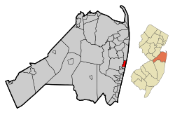 Map of Deal in Monmouth County. Inset: Location of Monmouth County in New Jersey. | |
 Census Bureau map of Deal, New Jersey | |
 Deal Location in Monmouth County  Deal Location in New Jersey  Deal Location in the United States | |
| Coordinates: 40.249701°N 73.997458°W[1][2] | |
| Country | |
| State | |
| County | Monmouth |
| Incorporated | March 7, 1898 |
| Named for | Deal, Kent, England |
| Government | |
| • Type | Walsh Act |
| • Body | Board of Commissioners |
| • Mayor | Samuel M. Cohen (term ends May 12, 2020)[4][5] |
| • Administrator / Municipal clerk | Stephen R. Carasia[4] |
| Area | |
| • Total | 1.318 sq mi (3.415 km2) |
| • Land | 1.240 sq mi (3.212 km2) |
| • Water | 0.078 sq mi (0.203 km2) 5.95% |
| Area rank | 469th of 566 in state 40th of 53 in county[1] |
| Elevation | 30 ft (9 m) |
| Population | |
| • Total | 750 |
| • Estimate (2019)[10] | 719 |
| • Rank | 546th of 566 in state 51st of 53 in county[11] |
| • Density | 604.8/sq mi (233.5/km2) |
| • Density rank | 426th of 566 in state 49th of 53 in county[11] |
| Time zone | UTC−05:00 (Eastern (EST)) |
| • Summer (DST) | UTC−04:00 (Eastern (EDT)) |
| ZIP Code | |
| Area code(s) | 732 exchanges: 517, 531, 660, 663[14] |
| FIPS code | 3402516660[1][15][16] |
| GNIS feature ID | 0885194[1][17] |
| Website | www |
Deal boasts a significant population of Orthodox Sephardic Jews, mainly of Syrian extraction. In the 2000 Census, 16.4% of Deal residents identified as being of Syrian heritage, the greatest percentage of Syrian Americans in any municipality in the country.[19] As much as 80% of Deal's population are Sephardi Jews, and the population swells to over 6,000 during the summer, many of them Syrian Jews.[20][21] Most of the town consisted of homes close to or over one hundred years old in the Victorian and American Foursquare styles.
Deal was ranked in 2007 by Forbes magazine as the 13th most expensive ZIP Code in the United States, with a median sale price of $1,825,000.[22] It was also named the 4th most expensive zip code in New Jersey in 2017, with a median sale price of $1,207,500.[23] In 2019, PropertyShark ranked Deal in a tie with 94110 in San Francisco as the 85th most expensive ZIP Code in the country, and second-highest in New Jersey, with a median sales price of $1,500,000[24]
History
A group from Rhode Island settled in the area of Middletown Township and Shrewsbury Township in the mid-1660s, after having purchased what was known as the Monmouth Patent. Thomas Whyte, an English carpenter from the shore-side community of Deal, Kent, acquired 500 acres (200 ha) in Shrewsbury Township along the shore that became known as "Deal", from the name of the English town.[25][26] Present-day Norwood Avenue dates back to the early 18th century construction of the Long Branch-Deal Turnpike.[27]
On August 14, 1829, at 11:30 PM local time, the fall of a meteorite was observed.[28] The weight of the recovered stone was 28 grams (0.99 oz). The meteorite was officially named "Deal" and it was classified as an ordinary chondrite L.[29]
Deal was incorporated as a borough on March 7, 1898, by an act of the New Jersey Legislature, from portions of Ocean Township.[27][30]
During World War II, Deal Beach was known as place for German spies to enter into the United States by submarine. People were warned to not go to the beach or shine lights in that direction. There was a big sign on a rock with a warning.
In the summer of 2009, several residents of Deal were involved in a scandal called Operation Bid Rig, which involved public corruption, money laundering and trafficking of human organs.[31]
Geography
According to the United States Census Bureau, the borough had a total area of 1.318 square miles (3.415 km2), including 1.240 square miles (3.212 km2) of land and 0.098 square miles (0.203 km2) of water (5.95%).[1][2] The borough's beaches have been expanded significantly due to reclamation of the beach by way of dredging.
Unincorporated communities, localities and place names located partially or completely within the borough include South Elberon.[32]
The borough borders the Monmouth County communities of Allenhurst, Long Branch and Ocean Township.[33][34][35]
Deal Lake covers 158 acres (64 ha) and is overseen by the Deal Lake Commission, which was established in 1974. Seven municipalities border the lake, accounting for 27 miles (43 km) of shoreline, also including Allenhurst, Asbury Park, Interlaken, Loch Arbour, Neptune Township and Ocean Township.[36]
Demographics
| Historical population | |||
|---|---|---|---|
| Census | Pop. | %± | |
| 1900 | 70 | — | |
| 1910 | 273 | 290.0% | |
| 1920 | 420 | 53.8% | |
| 1930 | 800 | 90.5% | |
| 1940 | 917 | 14.6% | |
| 1950 | 1,064 | 16.0% | |
| 1960 | 1,889 | 77.5% | |
| 1970 | 2,401 | 27.1% | |
| 1980 | 1,952 | −18.7% | |
| 1990 | 1,179 | −39.6% | |
| 2000 | 1,070 | −9.2% | |
| 2010 | 750 | −29.9% | |
| Est. 2019 | 719 | [10][37] | −4.1% |
| Population sources: 1900-1920[38] 1900-1910[39] 1910-1930[40] 1930-1990[41] 2000[42][43] 2010[7][8][9] | |||
Census 2010
The 2010 United States Census counted 750 people, 333 households, and 182.151 families in the borough. The population density was 604.8 per square mile (233.5/km2). There were 926 housing units at an average density of 746.7 per square mile (288.3/km2). The racial makeup of the borough was 91.60% (687) White, 1.60% (12) Black or African American, 0.00% (0) Native American, 3.47% (26) Asian, 0.13% (1) Pacific Islander, 2.00% (15) from other races, and 1.20% (9) from two or more races. Hispanic or Latino of any race were 7.33% (55) of the population.[7]
The 333 households accounted 12.9% with children under the age of 18 living with them; 40.8% were married couples living together; 9.6% had a female householder with no husband present, and 45.3% were non-families. Of all households, 35.7% were made up of individuals, and 17.1% had someone living alone who was 65 years of age or older. The average household size was 2.25 and the average family size was 2.90.[7]
In the borough, the population age was spread out with 14.3% under the age of 18, 11.9% from 18 to 24, 17.6% from 25 to 44, 27.6% from 45 to 64, and 28.7% who were 65 years of age or older. The median age was 50.9 years. For every 100 females, the population had 88.0 males. For every 100 females ages 18 and older there were 82.7 males.[7]
The Census Bureau's 2006–2010 American Community Survey showed that (in 2010 inflation-adjusted dollars) median household income was $59,615 (with a margin of error of +/- $17,199) and the median family income was $95,833 (+/- $32,359). Males had a median income of $52,625 (+/- $17,303) versus $25,139 (+/- $4,348) for females. The per capita income for the borough was $46,867 (+/- $8,038). About 4.1% of families and 6.7% of the population were below the poverty line, including 7.4% of those under age 18 and 3.6% of those age 65 or over.[44]
Census 2000
As of the 2000 United States Census[15] there were 1,070 people, 434 households, and 289 families residing in the borough. The population density was 880.5 people per square mile (338.6/km2). There were 953 housing units at an average density of 784.3 per square mile (301.6/km2). The racial makeup of the borough was 94.39% White, 1.21% African American, 0.09% Native American, 0.28% Asian, 2.71% from other races, and 1.31% from two or more races. Hispanic or Latino people of any race were 5.05% of the population.[42][43]
There were 434 households, out of which 19.8% had children under the age of 18 living with them, 56.2% were married couples living together, 7.1% had a female householder with no husband present, and 33.2% were non-families. 29.0% of all households were made up of individuals, and 13.6% had someone living alone who was 65 years of age or older. The average household size was 2.46 and the average family size was 3.02.[42][43]
In the borough the population was spread out, with 20.5% under the age of 18, 7.9% from 18 to 24, 21.9% from 25 to 44, 23.0% from 45 to 64, and 26.7% who were 65 years of age or older. The median age was 45 years. For every 100 females, there were 100.0 males. For every 100 females age 18 and over, there were 94.7 males.[42][43]
The median income for a household in the borough was $58,472, and the median income for a family was $65,313. Males had a median income of $57,857 versus $27,813 for females. The per capita income for the borough was $38,510. About 7.8% of families and 11.2% of the population were below the poverty line, including 14.0% of those under age 18 and 6.6% of those age 65 or over.[42][43]
Government
Local government
Deal is governed under the Walsh Act form of government by a three-person Board of Commissioners whose members are chosen in non-partisan voting to serve four-year terms of office on a concurrent basis as part of the November general election.[3][45][46]
As of 2020, members of the Deal Committee are Mayor Samuel M. Cohen (Commissioner of Public Affairs and Public Safety), Morris Ades (Commissioner of Revenue and Finance) and David Simhon (Commissioner of Public Works, Parks and Public Property), all serving concurrent terms of office ending May 12, 2020.[4][47][48][49][50][51]
Mayor Harry Franco, who had first been elected as a commissioner, died on January 30, 2013.[52]
Federal, state and county representation
Deal is located in the 6th Congressional District[53] and is part of New Jersey's 11th state legislative district.[8][54][55]
For the 116th United States Congress, New Jersey's Sixth Congressional District is represented by Frank Pallone (D, Long Branch).[56][57] New Jersey is represented in the United States Senate by Democrats Cory Booker (Newark, term ends 2021)[58] and Bob Menendez (Paramus, term ends 2025).[59][60]
For the 2018–2019 session (Senate, General Assembly), the 11th Legislative District of the New Jersey Legislature is represented in the State Senate by Vin Gopal (D, Long Branch) and in the General Assembly by Joann Downey (D, Freehold Township) and Eric Houghtaling (D, Neptune Township).[61][62]
Monmouth County is governed by a Board of Chosen Freeholders consisting of five members who are elected at-large to serve three year terms of office on a staggered basis, with either one or two seats up for election each year as part of the November general election. At an annual reorganization meeting held in the beginning of January, the board selects one of its members to serve as Director and another as Deputy Director.[63] As of 2020, Monmouth County's Freeholders are Freeholder Director Thomas A. Arnone (R, Neptune City, term as freeholder ends December 31, 2022; term as freeholder director ends 2021),[64] Freeholder Deputy Director Susan M. Kiley (R, Hazlet Township, term as freeholder ends December 31, 2021; term as deputy freeholder director ends 2021),[65] Lillian G. Burry (R, Colts Neck Township, 2020),[66] Nick DiRocco (R, Wall Township, 2022),[67] and Patrick G. Impreveduto (R, Holmdel Township, 2020)[68].
Constitutional officers elected on a countywide basis are County clerk Christine Giordano Hanlon (R, 2020; Ocean Township),[69][70] Sheriff Shaun Golden (R, 2022; Howell Township),[71][72] and Surrogate Rosemarie D. Peters (R, 2021; Middletown Township).[73][74]
Politics
As of March 23, 2011, there were a total of 616 registered voters in Deal, of which 113 (18.3%) were registered as Democrats, 146 (23.7%) were registered as Republicans and 357 (58.0%) were registered as Unaffiliated. There were no voters registered to other parties.[75]
In the 2012 presidential election, Republican Mitt Romney received 71.4% of the vote (225 cast), ahead of Democrat Barack Obama with 27.9% (88 votes), and other candidates with 0.6% (2 votes), among the 316 ballots cast by the borough's 602 registered voters (1 ballot was spoiled), for a turnout of 52.5%.[76][77] In the 2008 presidential election, Republican John McCain received 71.0% of the vote (303 cast), ahead of Democrat Barack Obama with 25.8% (110 votes) and other candidates with 0.5% (2 votes), among the 427 ballots cast by the borough's 678 registered voters, for a turnout of 63.0%.[78] In the 2004 presidential election, Republican George W. Bush received 66.7% of the vote (314 ballots cast), outpolling Democrat John Kerry with 32.1% (151 votes) and other candidates with 0.5% (4 votes), among the 471 ballots cast by the borough's 768 registered voters, for a turnout percentage of 61.3.[79]
In the 2013 gubernatorial election, Republican Chris Christie received 75.8% of the vote (122 cast), ahead of Democrat Barbara Buono with 22.4% (36 votes), and other candidates with 1.9% (3 votes), among the 163 ballots cast by the borough's 597 registered voters (2 ballots were spoiled), for a turnout of 27.3%.[80][81] In the 2009 gubernatorial election, Republican Chris Christie received 65.4% of the vote (172 ballots cast), ahead of Democrat Jon Corzine with 31.6% (83 votes), Independent Chris Daggett with 3.0% (8 votes) and other candidates with 0.0% ( votes), among the 263 ballots cast by the borough's 654 registered voters, yielding a 40.2% turnout.[82]
Education
The Deal School District serves public school students in kindergarten through eighth grade at Deal School. As of the 2017–18 school year, the district, comprising one school, had an enrollment of 165 students and 17.1 classroom teachers (on an FTE basis), for a student–teacher ratio of 9.7:1.[83] In the 2016–17 school year, Deal had the 35th-smallest enrollment of any school district in the state, with 165 students.[84] In the 2013–14 school year, nearly 90% of the district's enrollment was from students participating in the Interdistrict Public School Choice Program, for whom the state paid the district $12,500 in supplemental aid per student.[85]
For ninth through twelfth grades, students attend Shore Regional High School, as part of a sending/receiving relationship.[86] As of the 2017–18 school year, the high school had an enrollment of 651 students and 56.0 classroom teachers (on an FTE basis), for a student–teacher ratio of 11.6:1.[87] The relationship with Shore Regional succeeds a previous agreement under which students from deal attended Asbury Park High School in neighboring Asbury Park as part of a sending/receiving relationship with the Asbury Park Public Schools.[88][89]
Students also have the option to attend Academy Charter High School in Lake Como, which accepts students on a lottery basis from the communities of Allenhurst, Asbury Park, Avon-by-the-Sea, Belmar, Bradley Beach, Deal, Interlaken and Lake Como.[88][90]
Houses of worship
Area synagogues[91] and churches include:
- Edmond J. Safra Synagogue of Deal, the Hathaway Avenue Synagogue (Orthodox, Syrian traditions)[92]
- Bet Yosef, Hechal Shaul Synagogue, Ahaba Ve Ahva (Orthodox, Syrian traditions, Egyptian traditions)[93]
- Magen David of West Deal, (Orthodox, Syrian traditions)[94]
- Ohel Yaakob, the Lawrence Avenue Synagogue (Orthodox, Syrian traditions)[95]
- Ohel Simha, the Park Avenue Synagogue (Orthodox, Syrian traditions)[96]
- Synagogue of Deal (Orthodox, Syrian traditions)
- Saint Mary's of the Assumption, at Richmond Avenue (Roman Catholic)[97]
- Joseph S. Jemal Synagogue of Deal extension of the Hathaway Synagogue (Orthodox, Syrian traditions)[92]
Transportation
_at_Roseld_Avenue_in_Deal%2C_Monmouth_County%2C_New_Jersey.jpg)
Roads and highways
As of May 2010, the borough had a total of 18.57 miles (29.89 km) of roadways, of which 17.11 miles (27.54 km) were maintained by the municipality, 0.00 miles (0 km) by Monmouth County and 1.46 miles (2.35 km) by the New Jersey Department of Transportation.[98]
New Jersey Route 71 is the only state highway serving Deal directly. However, several other highways are accessible in neighboring towns, including New Jersey Route 35, New Jersey Route 18, New Jersey Route 66 and the Garden State Parkway.
Public transportation
NJ Transit provides local bus transportation on the 837 route. NJ Transit service on the North Jersey Coast Line is available at the Allenhurst and Elberon stations.[99]
Climate
According to the Köppen climate classification system, Deal, New Jersey has a humid subtropical climate (Cfa). Cfa climates are characterized by all months having an average mean temperature > 32.0 °F (> 0.0 °C), at least four months with an average mean temperature ≥ 50.0 °F (≥ 10.0 °C), at least one month with an average mean temperature ≥ 71.6 °F (≥ 22.0 °C) and no significant precipitation difference between seasons. During the summer months at Deal, a cooling afternoon sea breeze is present on most days, but episodes of extreme heat and humidity can occur with heat index values ≥ 95 °F (≥ 35 °C). During the winter months, episodes of extreme cold and wind can occur with wind chill values < 0 °F (< -18 °C). The plant hardiness zone at Deal Beach is 8a with an average annual extreme minimum air temperature of 13 °F on February 15, 2020 (-15.9 °C).[100][101] The average seasonal (November–April) snowfall total is 18 to 24 inches (46 to 61 cm) and the average snowiest month is February which corresponds with the annual peak in nor'easter activity.
| Climate data for Deal Beach, NJ (1981-2010 averages) | |||||||||||||
|---|---|---|---|---|---|---|---|---|---|---|---|---|---|
| Month | Jan | Feb | Mar | Apr | May | Jun | Jul | Aug | Sep | Oct | Nov | Dec | Year |
| Average high °F (°C) | 39.9 (4.4) |
42.5 (5.8) |
49.0 (9.4) |
58.7 (14.8) |
68.2 (20.1) |
77.5 (25.3) |
82.8 (28.2) |
81.5 (27.5) |
75.4 (24.1) |
65.1 (18.4) |
55.2 (12.9) |
45.1 (7.3) |
61.8 (16.6) |
| Daily mean °F (°C) | 32.4 (0.2) |
34.7 (1.5) |
40.9 (4.9) |
50.3 (10.2) |
59.9 (15.5) |
69.4 (20.8) |
74.9 (23.8) |
73.8 (23.2) |
67.3 (19.6) |
56.4 (13.6) |
47.3 (8.5) |
37.7 (3.2) |
53.8 (12.1) |
| Average low °F (°C) | 24.9 (−3.9) |
26.9 (−2.8) |
32.7 (0.4) |
41.9 (5.5) |
51.6 (10.9) |
61.3 (16.3) |
67.1 (19.5) |
66.1 (18.9) |
59.3 (15.2) |
47.7 (8.7) |
39.4 (4.1) |
30.2 (−1.0) |
45.8 (7.7) |
| Average precipitation inches (mm) | 3.61 (92) |
3.06 (78) |
3.87 (98) |
4.19 (106) |
3.93 (100) |
3.58 (91) |
4.69 (119) |
4.83 (123) |
3.67 (93) |
4.00 (102) |
3.81 (97) |
4.03 (102) |
47.27 (1,201) |
| Average relative humidity (%) | 64.9 | 62.0 | 60.5 | 62.1 | 66.0 | 70.5 | 69.9 | 71.7 | 71.6 | 69.4 | 67.3 | 65.3 | 66.8 |
| Average dew point °F (°C) | 21.9 (−5.6) |
23.0 (−5.0) |
28.3 (−2.1) |
37.8 (3.2) |
48.5 (9.2) |
59.4 (15.2) |
64.4 (18.0) |
64.1 (17.8) |
57.8 (14.3) |
46.5 (8.1) |
37.0 (2.8) |
27.1 (−2.7) |
43.1 (6.2) |
| Source: PRISM[102] | |||||||||||||
| Climate data for Sandy Hook, NJ Ocean Water Temperature (15 N Deal) | |||||||||||||
|---|---|---|---|---|---|---|---|---|---|---|---|---|---|
| Month | Jan | Feb | Mar | Apr | May | Jun | Jul | Aug | Sep | Oct | Nov | Dec | Year |
| Daily mean °F (°C) | 37 (3) |
36 (2) |
40 (4) |
46 (8) |
55 (13) |
62 (17) |
69 (21) |
72 (22) |
68 (20) |
59 (15) |
51 (11) |
43 (6) |
53 (12) |
| Source: NOAA[103] | |||||||||||||
Ecology
According to the A. W. Kuchler U.S. potential natural vegetation types, Deal has an Appalachian Oak (104) vegetation type with an Eastern Hardwood Forest (25) vegetation form.[104]
Notable people
People who were born in, residents of, or otherwise closely associated with Deal include:
- Rudolf Bauer (1889–1953), German-born painter who was involved in the avant-garde group Der Sturm in Berlin, and whose work would become central to the Non-Objective art collection of Solomon R. Guggenheim[105]
- Joseph Cayre (born 1941), investor and owner of Midtown Equities[106]
- Stanley Chera (1942–2020), real estate developer[107]
- Nadine Epstein, journalist and author; editor in chief and CEO of Moment magazine[108]
- George K. Fraenkel (1921–2009), physical chemist[109]
- Tom Gallagher (1940–2018), diplomat; in 1976, became the first officer of the United States Foreign Service to come out as gay[110]
- Frank Hague (1876–1956), Mayor of Jersey City, 1917–1947[111]
- Huntington Hartford (1911–2008), businessman, philanthropist, stage and film producer, and art collector; heir to the A&P supermarket fortune[112]
- Sean T. Kean (born 1963), politician; has served in the New Jersey General Assembly since being sworn into office on January 10, 2012, representing the 30th Legislative District[113]
- Albert Laboz, real estate developer[114]
- David Rockwell (born 1956), architect and designer[115]
- Patti Scialfa (born 1953), member of the E Street Band and wife of Bruce Springsteen[116]
- P. Hal Sims (1886–1949) and Dorothy Rice Sims (1889–1960), contract bridge celebrities and experts whose home in Deal was a headquarters and retreat for authorities on the game, 1920s–30s[117]
- Joseph Sitt (born 1964), real estate investor, founder of the retail chain Ashley Stewart, and founder of global real estate company Thor Equities[106]
- Maxine Stuart (1918–2013), actress[118]
- Jeff Sutton (born 1960), real estate developer, billionaire, founder of Wharton Properties[119]
- Jeffrey Vinik (born 1959), investor and owner of the NHL's Tampa Bay Lightning[120]
References
- 2010 Census Gazetteer Files: New Jersey County Subdivisions, United States Census Bureau. Accessed May 21, 2015.
- US Gazetteer files: 2010, 2000, and 1990, United States Census Bureau. Accessed September 4, 2014.
- 2012 New Jersey Legislative District Data Book, Rutgers University Edward J. Bloustein School of Planning and Public Policy, March 2013, p. 94.
- Administration, Borough of Deal. Accessed March 26, 2020.
- 2020 New Jersey Mayors Directory, New Jersey Department of Community Affairs. Accessed February 1, 2020.
- U.S. Geological Survey Geographic Names Information System: Borough of Deal, Geographic Names Information System. Accessed March 5, 2013.
- DP-1 - Profile of General Population and Housing Characteristics: 2010 for Deal borough, Monmouth County, New Jersey Archived February 12, 2020, at Archive.today, United States Census Bureau. Accessed July 18, 2012.
- Municipalities Sorted by 2011-2020 Legislative District, New Jersey Department of State. Accessed February 1, 2020.
- Profile of General Demographic Characteristics: 2010 for Deal borough Archived 2016-08-05 at the Wayback Machine, New Jersey Department of Labor and Workforce Development. Accessed July 18, 2012.
- Annual Estimates of the Resident Population for Minor Civil Divisions in New Jersey: April 1, 2010 to July 1, 2019, United States Census Bureau. Accessed May 21, 2020.
- GCT-PH1 Population, Housing Units, Area, and Density: 2010 - State -- County Subdivision from the 2010 Census Summary File 1 for New Jersey Archived February 12, 2020, at Archive.today, United States Census Bureau. Accessed December 3, 2012.
- Look Up a ZIP Code for Deal, NJ, United States Postal Service. Accessed July 18, 2012.
- Zip Codes, State of New Jersey. Accessed September 17, 2013.
- Area Code Lookup - NPA NXX for Deal, NJ, Area-Codes.com. Accessed September 17, 2013.
- U.S. Census website , United States Census Bureau. Accessed September 4, 2014.
- Geographic Codes for New Jersey, Missouri Census Data Center. Accessed September 1, 2019.
- US Board on Geographic Names, United States Geological Survey. Accessed September 4, 2014.
- Table 7. Population for the Counties and Municipalities in New Jersey: 1990, 2000 and 2010, New Jersey Department of Labor and Workforce Development, February 2011. Accessed July 18, 2012.
- Syrian Communities, accessed May 28, 2006.
- "It's a Summer Thing; For Like-Minded New Yorkers, a Season of Separation", The New York Times, May 26, 1996. Accessed May 22, 2015. "The psychiatrists are on Cape Cod, the black professionals are in Azurest on Long Island and the Syrian Jews are in Deal on the Jersey shore."
- Fahim, Kareem. "Sephardic Jews Developed Haven on the Jersey Shore", The New York Times, July 24, 2009. Accessed July 18, 2012. "In the late 1960s, Sephardic Jews who lived in Brooklyn and spent summers in nearby Bradley Beach began buying land in Deal; by 1973, more than 100 families had bought property in the town. By the mid-1990s, thousands of Sephardic Jews were flocking to the town during the summers, and today, local historians estimate, they make up 80 percent of the population."
- "Most Expensive ZIP Codes: #13 07723", Forbes. Accessed June 4, 2015.
- . Accessed February 20, 2018.
- Top Most Expensive U.S. Zip Codes in 2019, PropertyShark,November 18, 2019. Accessed December 14, 2019. "Monmouth County contributed New Jersey’s second ultra-pricey zip. At $1,500,000, Deal’s 07723 shared #85 with San Francisco’s 94110."
- Hutchinson, Viola L. The Origin of New Jersey Place Names, New Jersey Public Library Commission, May 1945. Accessed August 28, 2015.
- Gannett, Henry. The Origin of Certain Place Names in the United States, p. 102. United States Government Printing Office, 1905. Accessed August 28, 2015.
- Deal's History Archived 2006-03-24 at the Wayback Machine. Borough of Deal. Accessed May 28, 2006.
- Academy of Natural Sciences of Philadelphia, Proceedings of the Academy of Natural Sciences of Philadelphia, Volume 72, page 358. The Academy, 1921.
- Meteoritical Bulletin Database: Deal
- Snyder, John P. The Story of New Jersey's Civil Boundaries: 1606-1968, Bureau of Geology and Topography; Trenton, New Jersey; 1969. p. 178. Accessed July 18, 2012.
- Solis, Steph; and Mikle, Jean. 'Solomon Dwek, 42, released early from federal prison", Asbury Park Press, March 23, 2015. Accessed May 22, 2015. "Dwek's prominence in the Sephardic Jewish community in Deal gave him access to people like Rabbi Saul Kassin, the head of the Sephardic community in the United States, and Rabbi Eliahu Ben-Haim, a relative of Dwek's. Both pleaded guilty to charges related to money laundering."
- Locality Search, State of New Jersey. Accessed May 21, 2015.
- Areas touching Deal, MapIt. Accessed March 26, 2020.
- Regional Location Map, Monmouth County, New Jersey. Accessed March 26, 2020.
- New Jersey Municipal Boundaries, New Jersey Department of Transportation. Accessed November 15, 2019.
- Home Page, Deal Lake Commission. Accessed July 8, 2015. "The Deal Lake Commission was created by the seven Monmouth County, NJ towns that surround Deal Lake. The Commission was chartered in 1974 by the Borough of Allenhurst, City of Asbury Park, Borough of Deal, Borough of Interlaken, Village of Loch Arbour, Neptune Township, and Ocean Township."
- Census Estimates for New Jersey April 1, 2010 to July 1, 2019, United States Census Bureau. Accessed May 21, 2020.
- Compendium of censuses 1726-1905: together with the tabulated returns of 1905, New Jersey Department of State, 1906. Accessed September 16, 2013.
- Thirteenth Census of the United States, 1910: Population by Counties and Minor Civil Divisions, 1910, 1900, 1890, United States Census Bureau, p. 337. Accessed July 17, 2012.
- Fifteenth Census of the United States : 1930 - Population Volume I, United States Census Bureau, p. 717. Accessed July 17, 2012.
- New Jersey Resident Population by Municipality: 1930 - 1990, Workforce New Jersey Public Information Network. Accessed June 28, 2015.
- Census 2000 Profiles of Demographic / Social / Economic / Housing Characteristics for Deal borough, New Jersey Archived 2016-08-12 at the Wayback Machine, United States Census Bureau. Accessed July 18, 2012.
- DP-1: Profile of General Demographic Characteristics: 2000 - Census 2000 Summary File 1 (SF 1) 100-Percent Data for Deal borough, Monmouth County, New Jersey Archived February 12, 2020, at Archive.today, United States Census Bureau. Accessed July 18, 2012.
- DP03: Selected Economic Characteristics from the 2006-2010 American Community Survey 5-Year Estimates for Deal borough, Monmouth County, New Jersey Archived February 12, 2020, at Archive.today, United States Census Bureau. Accessed July 18, 2012.
- "The Commission Form of Municipal Government", p. 53. Accessed June 3, 2015.
- "Forms of Municipal Government in New Jersey", p. 8. Rutgers University Center for Government Studies. Accessed June 3, 2015.
- 2019 Municipal Data Sheet , Borough of Deal. Accessed September 15, 2019.
- Meeting Minutes May 27, 2016, Borough of Deal. Accessed September 15, 2019. "The Borough Clerk then called for a nomination for the office of Mayor and as such, Director of the Department Public Affairs and Public Safety, whereupon Morris Ades nominated Samuel Cohen for such office and designation.... Mayor Cohen then nominated Morris Ades Director of Revenue and Finance, which nomination was seconded by Commissioner Simhon.... Mayor Cohen then nominated David Simhon as Director of Streets, Public Improvements, Parks and Public Property, which nomination was seconded by Commissioner Ades."
- Monmouth County Directory 2018, Monmouth County, New Jersey. Accessed September 15, 2019.
- May 10, 2016 Municipal Elections Official Results, Monmouth County, New Jersey, updated May 12, 2016. Accessed July 14, 2016.
- Official Results from Municipal Election May 2016, Borough of Deal. Accessed March 26, 2020.
- Loder, Stephanie. "Deal Mayor Harry Franco, 79, dies following illness", Asbury Park Press, February 1, 2013. Accessed March 6, 2013. "Harry I. Franco, the borough's 13th mayor, died Wednesday following an illness. He was 79. Last year, Franco was re-elected to the borough's Board of Commissioners and then selected by commissioners to be mayor."
- Plan Components Report, New Jersey Redistricting Commission, December 23, 2011. Accessed February 1, 2020.
- 2019 New Jersey Citizen's Guide to Government, New Jersey League of Women Voters. Accessed October 30, 2019.
- Districts by Number for 2011-2020, New Jersey Legislature. Accessed January 6, 2013.
- Directory of Representatives: New Jersey, United States House of Representatives. Accessed January 3, 2019.
- Biography, Congressman Frank Pallone Jr. Accessed January 3, 2019. "Frank Pallone, Jr., was born in Long Branch, New Jersey, where he grew up and still resides."
- About Cory Booker, United States Senate. Accessed January 26, 2015. "He now owns a home and lives in Newark's Central Ward community."
- Biography of Bob Menendez, United States Senate, January 26, 2015. "He currently lives in Paramus and has two children, Alicia and Robert."
- Senators of the 116th Congress from New Jersey. United States Senate. Accessed April 17, 2019. "Booker, Cory A. - (D - NJ) Class II; Menendez, Robert - (D - NJ) Class I"
- Legislative Roster 2018-2019 Session, New Jersey Legislature. Accessed January 22, 2018.
- District 11 Legislators, New Jersey Legislature. Accessed January 22, 2018.
- Monmouth County Government, Monmouth County, New Jersey. Accessed February 18, 2018.
- Freeholder Thomas A. Arnone, Monmouth County, New Jersey. Accessed May 18, 2020.
- Freeholder Susan M. Kiley, Monmouth County, New Jersey. Accessed May 18, 2020.
- Freeholder Lillian G. Burry, Monmouth County, New Jersey. Accessed May 18, 2020.
- Freeholder John P. Curley, Monmouth County, New Jersey. Accessed May 18, 2020.
- Freeholder Patrick Impreveduto, Monmouth County, New Jersey. Accessed February 18, 2018.
- The Monmouth County Clerk, Monmouth County, New Jersey. Accessed May 18, 2020.
- Members List: Clerks, Constitutional Officers Association of New Jersey. Accessed May 18, 2020.
- About Sheriff Shaun Golden, Monmouth County Sheriff's Office. Accessed May 18, 2020.
- Members List: Sheriffs, Constitutional Officers Association of New Jersey. Accessed May 18, 2020.
- About the Surrogate, Monmouth County New Jersey. Accessed May 18, 2020.
- Members List: Surrogates, Constitutional Officers Association of New Jersey. Accessed May 18, 2020.
- Voter Registration Summary - Monmouth, New Jersey Department of State Division of Elections, March 23, 2011. Accessed December 3, 2012.
- "Presidential General Election Results - November 6, 2012 - Monmouth County" (PDF). New Jersey Department of Elections. March 15, 2013. Retrieved December 24, 2014.
- "Number of Registered Voters and Ballots Cast - November 6, 2012 - General Election Results - Monmouth County" (PDF). New Jersey Department of Elections. March 15, 2013. Retrieved December 24, 2014.
- 2008 Presidential General Election Results: Monmouth County, New Jersey Department of State Division of Elections, December 23, 2008. Accessed December 3, 2012.
- 2004 Presidential Election: Monmouth County, New Jersey Department of State Division of Elections, December 13, 2004. Accessed December 3, 2012.
- "Governor - Monmouth County" (PDF). New Jersey Department of Elections. January 29, 2014. Retrieved December 24, 2014.
- "Number of Registered Voters and Ballots Cast - November 5, 2013 - General Election Results - Monmouth County" (PDF). New Jersey Department of Elections. January 29, 2014. Retrieved December 24, 2014.
- 2009 Governor: Monmouth County Archived 2012-10-17 at the Wayback Machine, New Jersey Department of State Division of Elections, December 31, 2009. Accessed December 3, 2012.
- District information for Deal Boro School District, National Center for Education Statistics. Accessed November 1, 2019.
- Guion, Payton. "These 43 N.J. school districts have fewer than 200 students", NJ Advance Media for NJ.com, September 2017. Accessed January 30, 2020. "Based on data from the state Department of Education from the last school year and the Census Bureau, NJ Advance Media made a list of the smallest of the small school districts in the state, excluding charter schools and specialty institutions.... 35. Deal - Enrollment: 165; Grades: K-8; County: Monmouth"
- McGlone, Peggy. "NJ Interdistrict Choice program shows huge growth but limited reach", NJ Advance Media for NJ.com, June 8, 2014, updated March 29, 2019. Accessed February 20, 2020. "The K-8 district in the wealthy Monmouth County Shore town receives almost $2 million in extra state aid, $12,573 for each of its 145 out-of-town Choice students. Only 15 students in the district’s one school live in Deal."
- Public Minutes August 27, 2018, Deal School District. Accessed October 21, 2018. "Approve the tuition arrangement for the 2018-2019 School Year with Shore Regional High School at a rate of $10,824.32 per pupil for regular education."
- School data for Shore Regional High School, National Center for Education Statistics. Accessed November 1, 2019.
- Mullen, Shannon; Shields, Nancy; and Matheson, Kathy. "Crime, school solutions costly as city seeks rebirth; High school improving, but not enough, many say", Asbury Park Press, January 27, 2005. Accessed August 28, 2013. "It was the day of the charter school's annual lottery, when names of applicants are drawn at random to fill the last remaining slots in next fall's freshman class. Academy Charter, now in its seventh year, is free to students in Asbury Park and the seven nearby towns that are sending districts for Asbury Park High School: Allenhurst, Avon, Belmar, Bradley Beach, Deal, Interlaken and Lake Como, formerly South Belmar."
- Reorganization Agenda January 7, 2016, Shore Regional High School. Accessed October 21, 2018. "Whereas, the content of the announcement was to advise the public that the Deal Board of Education filed a Petition of Appeal with the Commissioner of Education to sever its Sending-Receiving Relationship with the Asbury Park Board of Education, and to establish a new Sending-Receiving Relationship with the Shore Regional High School Board of Education"
- Our Story, Academy Charter High School. Accessed October 21, 2018. "Academy Charter High School is a free public high school for residents of Allenhurst, Asbury Park, Avon, Belmar, Bradley Beach, Deal, Interlaken, and Lake Como."
- Synagogues, Jewish Federation of Monmouth County. Accessed May 22, 2015.
- History Archived 2017-07-22 at the Wayback Machine, Edmond J. Safra Synagogue. Accessed July 13, 2017.
- Home Page, Congregation Hechal Shaul of Deal. Accessed July 13, 2017. "The Prayers in Congregation Hechal Shaul are according to the customs of Egyptian Heritage of Ahaba Ve Ahva Cairo, Egypt."
- Home Page, Congregation Magen David of West Deal. Accessed February 15, 2015.
- About Us, Ohel Yaacob Congregation. Accessed February 15, 2015.
- Home Page, Congregation Ohel Simha. Accessed July 13, 2017.
- Home Page, Saint Mary of the Assumption Church. Accessed May 22, 2015.
- Monmouth County Mileage by Municipality and Jurisdiction, New Jersey Department of Transportation, May 2010. Accessed July 18, 2014.
- Monmouth County Bus / Rail connections, NJ Transit, backed up by the Internet Archive as of July 26, 2010. Accessed August 5, 2012.
- https://www.accuweather.com/en/us/deal/07723/february-weather/2208869?year=2020
- "USDA Interactive Plant Hardiness Map". United States Department of Agriculture. Retrieved August 1, 2019.
- "PRISM Climate Group, Oregon State University". Retrieved August 1, 2019.
- Water Temperature Table of All Coastal Regions, National Oceanic and Atmospheric Administration. Accessed March 18, 2020.
- U.S. Potential Natural Vegetation, Original Kuchler Types, v2.0 (Spatially Adjusted to Correct Geometric Distortions), Data Basin. Accessed March 18, 2020.
- Johnson, Ken. "A Failed Love and a Museum's Birth; Bauer Recalls Key Figures in the Guggenheim's Creation", The New York Times, August 21, 2014. Accessed March 21, 2017. "In 1939, after a brief imprisonment — Bauer had been included in the Nazi-organized exhibition 'Degenerate Art' two years earlier — he came to America, whereupon Guggenheim made him a hard-to-refuse offer. He would provide Bauer with a 25-room mansion in the shore town Deal, N.J., and a stipend of $15,000 a year (more than $255,000 today), the interest from a $300,000 trust fund."
- Stulbrg, Ariel. "Dominating Deal; Mapping out just how many properties NYC’s Syrian Jewish real estate moguls own in this Jersey Shore hamlet", The Real Deal (magazine), August 1, 2015. Accessed July 13, 2017. "Joe Sitt — CEO of Thor Equities, co-owner of Town Residential and founder of the Ashley Stewart clothing store — owns 71 Ocean Avenue, just up the beach from Sutton.... Joseph Cayre, the head of Midtown Equities, owns 18 and 24 Deal Esplanade and co-owns the adjacent plot at 11 Marine Place with his son Jack. "
- Seelye, Katharine Q. "Stanley Chera, Developer and Friend of Trump, Dies at 77", The New York Times, April 17, 2020. Accessed April 20, 2020. "As the coronavirus pandemic spread to New York, Mr. Trump advised Mr. Chera to leave the city and move to his summer home near the oceanfront town of Deal, N.J."
- Epstein, Nadine. "From the Editor", Moment (magazine), January 6, 2016. Accessed September 22, 2019. "I grew up in Deal, New Jersey, where many Jews from Aleppo now live."
- Hevesi, Dennis. "George K. Fraenkel, Pioneering Chemist, Dies at 87", The New York Times, June 27, 2009. Accessed August 10, 2012. "George Kessler Fraenkel was born in Deal, N.J., on July 27, 1921, and grew up in Scarsdale, N.Y. He was one of three children of Osmond and Helene Esberg Fraenkel."
- "Pride Network honors six New Jersey leaders this Saturday in Asbury Park", Pride Network, November 3, 2016. Accessed July 26, 2018. "Tom Gallagher grew up in the servant’s quarters in Deal where he and his family worked for the family that founded MGM and Random House."
- Olszewski, Anthony. "Jersey City Mayor Frank Hague's Shore house", Hudson County Facts, April 10, 2010, copied from Life (magazine), February 7, 1938. Accessed March 21, 2017. "Hague's $125,000 Summer home at Deal, N.J. was paid for by check of John Milton, long Hague's lawyer and close crony."
- Levinson, Marc. The Great A&P and the Struggle for Small Business in America, p. 133. Farrar, Straus and Giroux, 2011. ISBN 9781429969024. Accessed July 13, 2017. "Josephine Hartford O'Donnell and Josephine's brother, George Huntington Hartford II, had grown up amid wealth and privilege, first in a Park Avenue apartment, then in the exclusive shoreside town of Deal, New Jersey."
- Manual of the Legislature of New Jersey 2004, p. 261. Skinder-Strauss Associates, 2004. ISBN 1-57741-187-0. Accessed July 13, 2017. "Mr. Kean was born May 21, 1963, in Montclair. He grew up in Deal and is a graduate of Red Bank Catholic High School."
- Staff. "The Special Children's Center Annual Breakfast Fundraiser at the Laboz Home in Deal, NJ", The Jewish Voice, July 13, 2016. Accessed April 13, 2017.
- David Rockwell Biography, rockwellgroup. Accessed April 7, 2015. "David Rockwell, FAIA, has long harbored a fascination with immersive environments. He grew up in the theater—his mother, a vaudeville dancer and choreographer, often cast him in community repertory productions. But when he was 12, David's family had a dramatic scene change, moving from Deal, New Jersey to Guadalajara, Mexico."
- Stewart, Allison. "Patti Scialfa's Glory Days; With 'Lullaby,' the Boss's Wife Steps Into the Spotlight", The Washington Post, June 20, 2004. Accessed July 18, 2012. "Scialfa (pronounced SKAL-fah) grew up in the affluent suburb of Deal, N.J., and attended the prestigious jazz program at the University of Miami before moving to New York."
- Shattuck, Florence. "Do Women Excel Men at Bridge?", The Brooklyn Daily Eagle, May 14, 1933. Accessed March 25, 2015. "Dorothy Rice Sims is the charming hostess who presides over the beautiful Sims estate at Deal, N. J., which reminds one of the castles of the feudal barons in medieval days."
- Fox, Margalit. "Maxine Stuart, 94, Dies; Acted on Stage, Film and TV", The New York Times, June 17, 2013. Accessed July 13, 2017. "Maxine Shlivek was born on June 28, 1918, in Deal, N.J., and reared in Lawrence, on Long Island, and Manhattan."
- Kadoch, Joseph. "Real Estate Mogul Jeff Sutton Makes Waves on the Jersey Shore", Jewish Voice, January 25, 2012. Accessed July 13, 2017. "The owner of Wharton Properties, a commercial real estate company with prized holdings in New York City, made headlines recently when he purchased a property on the Jersey Shore for $22.6 million. Sporting 5.3 acres and an impressive 350 feet of beachfront, his new estate – located at 91 Ocean Avenue in Deal – represents one of the most expensive acquisitions made in Monmouth County real estate history."
- Staff. "Who is Jeff Vinik?" Archived 2015-05-20 at the Wayback Machine, Tampa Bay Times, February 5, 2010. Accessed June 2, 2015. "Born: March 22, 1959, Deal, N.J."
External links
| Wikimedia Commons has media related to Deal, New Jersey. |
- Deal Borough website
- Deal School District
- Deal School's 2015–16 School Report Card from the New Jersey Department of Education
- School Data for the Deal School District, National Center for Education Statistics
| Preceded by Long Branch |
Beaches of New Jersey | Succeeded by Allenhurst |

Places adjacent to Deal, New Jersey | ||||||||||
|---|---|---|---|---|---|---|---|---|---|---|
| ||||||||||