Santurce, San Juan, Puerto Rico
Santurce is a barrio in the municipality of San Juan, Puerto Rico. Its population in 2010 was 81,251.[1][2][3] It is also the biggest and most populated of all the districts in the capital with a bigger population than most municipalities of Puerto Rico and one of the most densely populated areas of the island (15,447.0 persons per square mile).[4]
Santurce | |
|---|---|
Barrio | |
 Aerial view of Santurce | |
| Anthem: "Soy de Santurce" | |
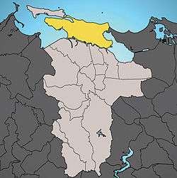 Location of Santurce shown in yellow | |
| Commonwealth | |
| Municipality | |
| Area | |
| • Total | 8.70 sq mi (22.53 km2) |
| • Land | 5.24 sq mi (13.57 km2) |
| • Water | 3.46 sq mi (8.96 km2) |
| Elevation | 49 ft (15 m) |
| Population | |
| • Total | 81,251 |
| • Density | 15,447.0/sq mi (6,931.2/km2) |
| (US Census 2010) | |
Summary
Santurce is one of the top ten most-populated areas of the island. It includes the neighborhoods of Miramar, Loíza, Isla Grande, Barrio Obrero, and Condado,[3] which are cultural hot spots for art, music, cuisine, fashion, hotels, technology, multimedia, film, textile and startups.
The 2010 U.S. Census recorded a total population of 81,251 people living in an area of 5.24 square miles (13.6 km2). It is the most populous borough (barrio) in Puerto Rico and one of the most densely populated areas of San Juan, at 15,447.0 residents per square mile (6,931.2/km²).[3]
Geography
Geographically speaking, Santurce is a peninsula that is attached to the mainland in the east, where it borders with the Isla Verde district of Carolina. It is 7.6 km long from west to east, and up to 3.0 km wide in the eastern part. The peninsula is bounded by the Atlantic Ocean in the north, with more than five km of beaches from the Condado peninsula in the west, to a point 600 m east of "Punta Las Marías", where it borders on the Isla Verde area, and "Laguna San José" and its northern embayment, "Laguna Los Corozos" to the east.
To the south is the Martín Peña Channel, which separates Santurce from the northern barrios of former municipio Río Piedras: Hato Rey Norte, Hato Rey Central, and Oriente. To the west is San Juan Bay, where three bridges, "Puente Dos Hermanos" (Ave. Ashford), "Puente G. Esteves" (Ave. Ponce de León) and "Puente San Antonio" (Ave. Fernandes Juncos) connect Santurce with "La Isleta" (small island) where Old San Juan is located. It has a total area of 8.70 square miles (22.5 km2) composed of 5.24 square miles (13.6 km2) of land and 3.46 square miles (9.0 km2) of water area.
The topography is mainly flat with low hills toward the central areas and swampy areas to the south along the Martín Peña Channel and to the east near the Laguna San José (San José Lagoon). The highest point is at Monteflores with 23 meters (75 feet).
Location
Santurce is located along the north-eastern coast of Puerto Rico. It lies south of the Atlantic Ocean, east of Old San Juan and west of Isla Verde. The district occupies an area of 5.24 square miles (13.6 km2) of land and 3.46 (8.96 km2) of water. It is surrounded by six bodies of water: San Juan Bay, Condado Natural Lagoon, the Martín Peña Channel, San José Lagoon, Los Corozos Lagoon, and the Atlantic Ocean with its respective beaches and estuaries.[5]
History
Colonial
Santurce was originally settled by the native Arawak and later by slaves of African ancestry who arrived from the neighboring Danish West Indies. Throughout the centuries, the district continued to grow due to its crossfade location between San Juan and its southern suburbs.[6]
Spanish influence
In 1876, an engineer from the port town of Santurtzi in Spain's autonomous Basque Country region known as Pablo Ubarri arrived on the island to help in the construction of a railroad system and a steam tramway between San Juan and the town of Río Piedras through the center of "Cangrejos" which prompted the gentrification of the district. Many years after his arrival he was granted the title of Count of Santurce (which is the Hispanicized equivalent of Santurtzi) by the Spanish Crown. With his newly acquired title and influence, the district was renamed after his title (a decision that has caused controversy ever since). The neighboring Condado also received its present-name from Ubarri's title, as the district's name literally translates to "county" (which in medieval tradition is land granted by a monarch to a count).[7]
Treaty of Paris (1898)
The Treaty of Paris provided that Cuba would become independent from Spain but the U.S. Congress made sure it would be under U.S. control through the Platt Amendment. It ceded to the United States Puerto Rico, and other adjacent islands then under Spanish sovereignty in the Caribbean, as well as Guam and the Philippines in Asia-Pacific region.[8]
The United States Army established the now historical Camp Las Casas, in the area of "Las Casas" in 1904. The camp was the main training base of the "Porto Rico Regiment of Infantry" (on January 15, 1899, the military government changed the name of Puerto Rico to Porto Rico and on May 17, 1932, U.S. Congress changed the name back to "Puerto Rico") The Porto Rico Regiment of Infantry was a segregated U.S. Army Regiment which was later renamed the "65th Infantry Regiment". Correction on the previous statement : The 65th Infantry Regiment was not segregated. It was a Regular Army Regiment that accepted personnel of every race but blacks, there was a black Regiment in the Island for that purpose, the 375th Regiment. The base continued in operation until 1946, when it was finally closed and the Residencial Las Casas now stands.[9]
The United States took control of Puerto Rico from Spain in the aftermath of the Spanish-American War under the terms of the Treaty of Paris of 1898. In 1899, the United States conducted its first census of Puerto Rico, finding that the population of Santurce was 5,840.[8]
The 20th century
In the 20th century the conurbation of the San Juan metropolis expanded rapidly beyond its walled confines of Old San Juan to incorporate the boroughs of suburban Miramar, Santurce, Isla Grande, and Condado, along the coast, as well as industrial Hato Rey, with its large sports stadium and modern financial district, and the college town of Río Piedras, immediately to the southeast.[10] Between 1937 and 1948, Santurce along with neighboring district Miramar became one of the most vibrant areas of the capital.[11] However, by the 1970s, most of the district had fallen into decay, losing the luster and vibrancy it once had. Many residents left Santurce, fleeing to the suburbs.[12] By 1980 the San Juan metropolitan area included the surrounding municipalities to the east and west and had about one-third of Puerto Rico's total population; that proportion has grown to two-thirds of the population.[13]
The 21st century
Santurce saw a period of economic decline coupled with the financial crisis of the local banking[14] & mortgage system.[15] In 2009, the district began a period of cosmopolitan revival and economic growth[16] as many local establishments such as bars, clubs, and restaurants opened their doors due to the importance of trade and tourism. What helped was the decrease in rent, it attracted artists to the area.[12]
Since then, Santurce began experiencing gentrification and is now hailed by many as Puerto Rico's "hipster Haven".[17][18]
Demographics
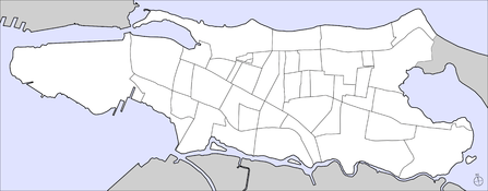
Subdivisions of Santurce
Santurce has a community of 81,251 of inhabitants living in a land area of 5.24 square miles (13.6 km2). It is subdivided into 40 "subbarrios" (sub-districts).
Population
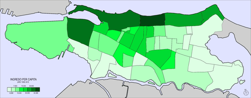
For centuries "barrios" have been the first "geo-political" division of Puerto Rico's municipalities, however presently they primarily serve statistical purposes for both the U.S. Census Bureau & the Puerto Rico Planning Board. The most densely populated area lies to the southeast bordering the San José Lagoon and the Martín Peña Channel, while the least densely populated areas are found by the mangrove swamps to the south surrounding the Martín Peña Channel, and the western area of Isla Grande, a decommissioned United States Navy military base.[1][8][2]

- For reference, see above locator map of "sub-barrios" (sub-districts) of Santurce
| Nr. | Sub-barrio | Land Area (m²) | Population (Census 2000) | Density km−2 | |
|---|---|---|---|---|---|
| 1 | Alto del Cabro | 156717 | 1164 | 7427.4 | |
| 2 | Barrio Obrero | 1034200 | 11467 | 11087.8 | |
| 3 | Bayola | 71645 | 564 | 7872.1 | |
| 4 | Bolívar | 163417 | 1223 | 7483.9 | |
| 5 | Buenos Aires | 446986 | 1303 | 2915.1 | |
| 6 | Campo Alegre | 123061 | 942 | 7654.7 | |
| 7 | Chícharo | 75355 | 722 | 9581.3 | |
| 8 | Condadito | 62470 | 748 | 11973.7 | |
| 9 | Condado | 824791 | 6170 | 7480.7 | |
| 10 | Figueroa | 350927 | 1016 | 2895.2 | |
| 11 | Gandul | 167753 | 2035 | 12130.9 | |
| 12 | Herrera | 123369 | 1841 | 14922.7 | |
| 13 | Hipódromo | 268195 | 2017 | 7520.6 | |
| 14 | Hoare | 363490 | 3 | 8.3 | |
| 15 | Isla Grande1) | 2039968 | 753 | 369.1 | |
| 16 | La Zona | 379687 | 1280 | 3371.2 | |
| 17 | Las Casas2) | 803500 | 6775 | 8431.9 | |
| 18 | Las Marías | 242223 | 1172 | 4838.5 | |
| 19 | Las Palmas | 316171 | 2772 | 8767.4 | |
| 20 | Loíza | 323012 | 2139 | 6622 | |
| 21 | Machuchal | 140008 | 1212 | 8656.6 | |
| 22 | María Moczó | 106196 | 1964 | 18494.1 | |
| 23 | Marruecos | 267165 | 0 | 0 | |
| 24 | Martín Peña | 185692 | 415 | 2234.9 | |
| 25 | Melilla | 129544 | 926 | 7148.2 | |
| 26 | Merhoff | 300801 | 2992 | 9946.8 | |
| 27 | Minillas | 215963 | 1484 | 6871.5 | |
| 28 | Miramar | 632154 | 5440 | 8605.5 | |
| 29 | Monteflores | 172397 | 1657 | 9611.5 | |
| 30 | Ocean Park4) | 520891 | 1976 | 3793.5 | |
| 31 | Parque | 299804 | 3251 | 10843.8 | |
| 32 | Pozo del Hato | 176987 | 137 | 774.1 | |
| 33 | Pulguero | 131613 | 1196 | 9087.2 | |
| 34 | Sagrado Corazón | 345472 | 1646 | 4764.5 | |
| 35 | San Juan Moderno | 91500 | 1083 | 11836.1 | |
| 36 | San Mateo | 168864 | 1989 | 11778.7 | |
| 37 | Seboruco | 167887 | 2198 | 13092.1 | |
| 38 | Shanghai | 686961 | 11331 | 16494.4 | |
| 39 | Tras Talleres | 168076 | 2453 | 14594.6 | |
| 40 | Villa Palmeras | 163389 | 2648 | 16206.7 | |
| Santurce | 13568557 | 81251 | 6932.7 | ||
| 1) recently named Puerto Rico Convention Center | |||||
| 2) including "Isla Guachinanga" in the "Laguna San José" | |||||
| 3) should be attributed to Merhoff Sub-Barrio (22) [19] | |||||
| 4) including "Isla Piedra" one km off the Atlantic coast | |||||
Cityscape
Architecture
Structures of architectural value and historical importance are located mainly throughout Avenida Ponce de León, Ashford Avenue and Avenida Fernández Juncos.
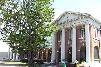
- Central High School, Spanish Renaissance style building from 1925: Designed by Adrian Finlayson, Architect (Project I-5)
- Colegio de Arquitectos, 225 Parque Street: Designed by Carlos del Valle Zeno, Architect (link)
- Condado Vanderbilt Hotel, Spanish Revival style hotel from 1919
- Convention Center, Isla Grande Boulevard
- La Casabella, Spanish influence from 1898
- La Concha Resort, a renaissance hotel: Designed by Toro Ferrer, Architects (link)
- Residencia Aboy-Lompré, 1919 house designed by Miguel Ferrer
Public spaces
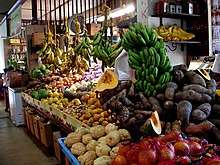
- La Placita de Santurce: Encompassing Campo Alegre, Alto del Cabro, and the Plaza del Mercado (a farmers' market full of local vendors with a social environment, bars, & restaurants),[20] La Placita de Santurce is one of the most popular nightlife areas in San Juan.[21][22]
- La Ventana al Mar (2004): Designed by Andrés Mignucci
- Plaza Antonia Quiñones (akas: Plaza Stella-Maris; Placita del Condado; 2000); designed by Andrés Mignucci
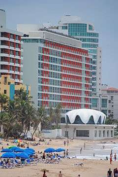
Beaches
- Condado Bridge Beach
- Ocean Park
Seaport
Transportation
Public transportation is provided by several bus lines (locally known as guaguas) operated by the Puerto Rico Metropolitan Bus Authority and circulate along the main avenues of Ponce de León and Fernández Juncos among others.
In the peripheries of Santurce there is a rapid transit system called Tren Urbano. The Sagrado Corazón terminal station is located in the southeast section of the district in the neighborhood of Martín Peña.
Santurce is a few minutes away by car from the country's main airport, Luis Muñoz Marín International Airport, and from San Juan's secondary commercial airport, Isla Grande Airport.
Culture
Museums and galleries
Santurce is the main residence of two major museums on the island.
- the Museum of Art of Puerto Rico
- the Puerto Rico Museum of Contemporary Art
- the Galería Casa Jefferson
Performing arts
- Ballets de San Juan
- Luis A. Ferré Performing Arts Center, modern award-winning fine arts architectural masterpiece
Education
Santurce is home to some of the most prestigious private education institutions in Puerto Rico.
- Conservatory of Music of Puerto Rico
- University of the Sacred Heart
- Academia San Jorge
- Academia Interamericana Metro
- Perpetuo Socorro
- Robinson School
- Saint John's School
It also includes notable public schools:
- Padre Rufo School, bilingual public school
- Central High School, built in 1925 and listed on the U.S. National Register of Historic Places
Synagogues and cathedrals
Santurce is home to one of the largest Jewish communities in Puerto Rico with over 1,500 people attending two local synagogues. Jews were officially prohibited from settling in the island through much of its history, but many managed to settle in the island as secret Jews.[23]
Many arrived from France, the Netherlands, Saint-Barthélemy and Curaçao after World War II. A minor portion are descendants of Jewish Cubans who came to establishment after Fidel Castro's Cuban Revolution of 1959. Like in many former Spanish colonies founded soon after the Spanish Inquisition, there are some Puerto Ricans who are Crypto-Jews. Recent DNA ancestry has identified a number of Portuguese descendants who arrived in Puerto Rico after the start of the Portuguese Inquisition in 1536. These are descendants of Conversó families. There are some who maintain elements of Jewish traditions, although they themselves are, or were raised as Christians.
- Episcopal Cathedral of St. John the Baptist (Catedral San Juan Bautista)
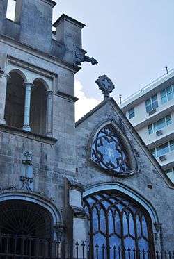
- Nuestra Señora de Lourdes Chapel, Neo-Gothic style chapel from 1909 designed by Antonin Nechodoma
- Sagrado Corazon Church (Parada 19)
- Synagogue Shaare Tzadik
- Stella Maris Catholic Church
- Temple Beth Shalom
- Parroquia San Vicente de Paúl (Parada 24)
Sports
Santurce has the most modern swimming facilities in the Caribbean and fourth in the world. It is an Olympic aquatic sports facility used to host local and international events such as the 2nd A.S.U.A Pan American Masters Swimming Championship. The San Juan Natatorium is located in Santurce's Central Park.
The district also has a baseball and a basketball team both known as the Santurce Crabbers (Cangrejeros de Santurce) because of the original name of the township. They have been part of the community for over 70 years. Both teams have enjoyed great domestic success, the baseball team is regarded as the ‘New York Yankees of Puerto Rico’, largely in part to the accomplishments of its legendary players, such as Roberto Clemente and Willie Mays.
Health
Santurce has an extensive healthcare network which includes two of the finest hospitals on the island, Ashford Presbyterian Community Hospital and Pavia Hospital.
Economy
Santurce experienced significant economic growth following World War II. During this period the district underwent an economic revitalization. Tourism is also a key industry based on Santurce's proximity to Puerto Rico's main international airport, Luis Muñoz Marín International Airport, and the smaller Fernando Luis Ribas Dominicci Airport. The concentration of hotels are primarily located in the Condado area where there are numerous luxurious hotels including La Concha Resort, Marriott and the Conrad Hotel.
Notable residents
- Miguel Arteta, film & television director
- Pura Belpré, author
- Giannina Braschi, author
- Tego Calderón, reggaeton singer
- Deborah Carthy-Deu, Miss Puerto Rico 1985, Miss Universe 1985; actress, television host
- Lourdes Chacón, actress
- Jessica Cristina, singer
- Carly Colón, professional wrestler and performer
- Christian Daniel, singer-songwriter and actor
- Jack Delano, author and photographer
- Benicio del Toro, actor and producer
- Edgar Diaz, professional baseball player
- José Ferrer, actor, director and producer
- Francisco Figueroa, professional boxer
- Eddie Gómez, bassist
- Wilfredo Gómez, professional boxer
- Sonia Gutierrez, educator,Hispanic rights activist.
- Nathan Leopold, US kidnapper
- Luis López Nieves, writer
- Isabel M. Mahesse, outstanding Supervisory Registered Nurse (RN), Ophtalmology, State Insurance Fund of Puerto Rico, RN career span to 39 years of service in Puerto Rico and USA Montefiore Hospital in New York and Walter Reed Medical Hospital in Washington, DC
- Gilberto Monroig, singer
- Andy Montañez, salsa singer for El Gran Combo
- Antonin Nechodoma, architect
- Edgard M Rodriguez Ocasio, Information Systems Professional
- Ossie Ocasio, professional boxer
- Cynthia Olavarria, Miss Universe Puerto Rico 2005 and first runner-up Miss Universe 2005
- Carlos Ponce; actor, singer and composer
- Jorge Posada, baseball player (New York Yankees)
- Ismael Rivera, salsa singer & performer
- Ed Romero, baseball player
- Luis Rafael Sánchez, writer
- Daniel Santos, singer and composer
- Arthur Schomburg, writer & historian
- Olga Tañón, singer
See also
References
- Picó, Rafael; Buitrago de Santiago, Zayda; Berrios, Hector H. Nueva geografía de Puerto Rico: física, económica, y social, por Rafael Picó. Con la colaboración de Zayda Buitrago de Santiago y Héctor H. Berrios. San Juan Editorial Universitaria, Universidad de Puerto Rico,1969.
- Gwillim Law (20 May 2015). Administrative Subdivisions of Countries: A Comprehensive World Reference, 1900 through 1998. McFarland. p. 300. ISBN 978-1-4766-0447-3. Retrieved 25 December 2018.
- Puerto Rico:2010:population and housing unit counts.pdf (PDF). U.S. Dept. of Commerce, Economics and Statistics Administration, U.S. Census Bureau. 2010.
- "Link to Puerto Rico - San Juan". Proyecto Salón Hogar (in Spanish). Retrieved November 29, 2012.
- Bliss, Peggy Ann. "A walking tour of Santurce". Puerto Rico Daily Sun. Retrieved 2010-03-29.
- Bliss, Peggy Ann. "A walking tour of Santurce (Part II)". Puerto Rico Daily Sun. Retrieved 2010-04-05.
- Cangrejos - Santurce - Authors; Aníbal Sepúlveda, Jorge Carbonell, Centro de Investigaciones CARIMAR, Oficina Estatal de Preservación Histórica.
- Joseph Prentiss Sanger; Henry Gannett; Walter Francis Willcox (1900). Informe sobre el censo de Puerto Rico, 1899, United States. War Dept. Porto Rico Census Office (in Spanish). Imprenta del gobierno. p. 162.
- "Historia Militar de Puerto Rico"; by Héctor Andrés Negroni; pg. 370; ISBN 84-7888-138-7
- Teleview Productions (Emerson Yorke Studios). "Report on Puerto Rico, U.S.A. (1955)". Prelinger Archives. Retrieved 2010-07-13.
- A. Sepúlveda. Cangrejos: Historia ilustrada de su desarrollo urbano. (1987) p. 45.
- Peffer, Randall (2002-10-01). Lonely Planet. Lonely Planet Publications. p. 142.
- Encyclopædia Britannica. "The Contemporary City". Encyclopædia Britannica. Retrieved 2010-07-07.
- Kotoky, Anurag (2009-05-04). "U.S. banking regulators move to clean up the financial mess in Puerto Rico". Reuters. Retrieved 2010-05-04.
- Dash, Eric (2010-04-29). "Puerto Rican Lenders Face Their Own Crisis". New York Times. Retrieved 2010-07-13.
- Peggy Ann Bliss. "$400,000 fund makes music for Santurce". Puerto Rico Daily Sun. Retrieved 2010-08-11.
- Squires, Kathleen (2015-01-12). "Neighborhood Guide: Santurce, San Juan's Hipster Haven". Fodors Travel Guide. Retrieved 2018-12-21.
- Travel (2015-02-26). "Take a walk on Puerto Rico's hipster side | National Post". Retrieved 2018-12-21.
- "Archived copy" (PDF). Archived from the original (PDF) on 2010-07-17. Retrieved 2010-03-14.CS1 maint: archived copy as title (link)
- "La Plaza del Mercado in Santurce, San Juan: The Complete Guide". TripSavvy. Retrieved 2018-12-21.
- "6 Puerto Rico TripAdvisor Tips We Love | ViaHero". www.viahero.com. Retrieved 2018-12-21.
- "La Placita de Santurce | San Juan & Around, Puerto Rico Nightlife". www.lonelyplanet.com. Retrieved 2018-12-21.
- Society For Crypto Judaic Studies, Harry Ezratty, Profile Archived 2008-04-30 at the Wayback Machine, cryptojews.com; accessed March 18, 2015.
External links
| Wikimedia Commons has media related to Santurce. |
| ||
| Barrios |
| |
| History |
| ||||||||
|---|---|---|---|---|---|---|---|---|---|
| Geography | |||||||||
| Ecology |
| ||||||||
| Politics | |||||||||
| Economy | |||||||||
| Society |
| ||||||||