Cupey, San Juan, Puerto Rico
Cupey is one of the 18 barrios of the municipality of San Juan, Puerto Rico. It is the largest barrio in the municipality and the third most populous with 36,659 inhabitants according to Census 2000.[1] The territorial land area of Cupey is 7.49 square miles (19.40 km²). It is bound by the municipality of Caguas to the South, by the municipality of Trujillo Alto to the East, by the barrios of Caimito and Monacillo to the West, and by the barrios of El Cinco and Sabana Llana Sur to the North. Between 1990 and 2000 Cupey had a 17.98% increase in population, more than any other barrio in San Juan.
Cupey | |
|---|---|
Barrio | |
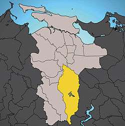 Location of Cupey shown in yellow. | |
| Commonwealth | |
| Municipality | |
| Area | |
| • Total | 7.55 sq mi (19.55 km2) |
| • Land | 7.49 sq mi (19.40 km2) |
| • Water | 0.06 sq mi (0.16 km2) |
| Population (2000) | |
| • Total | 36,659 |
| • Density | 4,897.6/sq mi (1,890.97/km2) |
| 2000 census | |
History
Established in 1878, this barrio was a former ward of the now defunct town of Río Piedras.[2] It was divided into the subbarrios of Cupey Alto and Cupey Bajo. It is named for the Cupey tree, which is indigenous to the Caribbean. It is sometimes spelled Copey, and the scientific name is Clusia rosea. It belongs to the family Clusiaceae.
The United States took control of Puerto Rico from Spain in the aftermath of the Spanish-American War under the terms of the Treaty of Paris of 1898. In 1899, the United States conducted its first census of Puerto Rico, finding that the population of Cupey barrio was 1,834.[3]
In 1956, the Puerto Rico Legislature integrated the town of Río Piedras and the town of San Juan. Today, Cupey is the biggest barrio in San Juan in territorial terms.
Features
Two of Puerto Rico's largest universities, Interamerican University of Puerto Rico's Metropolitan Campus, and Metropolitan University, a unit of the Ana G. Méndez University System, are located in Cupey.
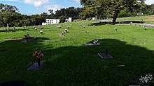
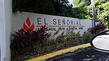
Renown TV personality and astrologer, Walter Mercado, is buried at Señorial Memorial Park in Cupey.[4]
Geography
Cupey barrio is 7.49 square miles (19.40 km²). It is bound to the north by the San Juan barrios of El Cinco along State Road PR-176, and by Sabana Llana Sur in the Venus Gardens neighborhood. From the south it is bound by the town of Caguas, starting at the intersection of state roads PR-176 and PR-175. From the east it is bound by the town of Trujillo Alto along state road PR-199. From the west it is bordered by the San Juan wards of Caimito, starting at the intersection of state road PR-199 and state highway PR-52, and by Monacillo, starting at the intersection of state
San Juan's only lake, Lago Las Curías, is located in Cupey. It was originally dammed in 1946 by the Municipal Government of San Juan to provide potable water to the cities of Río Piedras and San Juan, and was later transferred to the Puerto Rico Electric Power Authority (PREPA). it is currently owned by the Puerto Rico Aqueducts and Sewer Authority (PRASA). The earthen dam is approximately 75 feet high and 800 feet long and its design capacity is 1,120 acres-feet.[5]
Notable residents
- Cheo Feliciano, salsa legend
- Raul Julia, actor
- Rafael Hernández, composer and musician
- Lolita Lebrón, Puerto Rico Nationalist leader
- Kenneth McClintock, Secretary of State and Senate President
- Thomas Rivera Schatz, Senate President
- Jorge Santini, Mayor of San Juan
- Felix Trinidad, world champion boxer, member of the International Boxing Hall of Fame
- Felix Trinidad Sr., Puerto Rico national Featherweight boxing champion
See also
References
- Puerto Rico:2010:population and housing unit counts.pdf (PDF). U.S. Dept. of Commerce, Economics and Statistics Administration, U.S. Census Bureau. 2010. p. 32.
- Puerto Rico. Office of Historian (1949). Tesauro de datos historicos: indice compendioso de la literatura histórica de Puerto Rico, incluyendo algunos datos inéditos, periodísticos y cartográficos (in Spanish). Impr. del Gobierno de Puerto Rico. p. 306. Retrieved 4 January 2020.
- Joseph Prentiss Sanger; Henry Gannett; Walter Francis Willcox (1900). Informe sobre el censo de Puerto Rico, 1899, United States. War Dept. Porto Rico Census Office (in Spanish). Imprenta del gobierno. p. 162.
- "Walter Mercado Laid to Rest in Puerto Rico". Entertainment Tonight.
- "REPRESA LAS CURÍAS - Wikimapia". Wikimapia.org. Retrieved 16 August 2016.
| ||
| Barrios |
| |