Sandakpur, Nepal
Sandakpur (Nepali: सन्दकपुर गाउँपालिका) is a rural municipality (gaunpalika) out of six rural municipality located in Ilam District of Province No. 1 of Nepal. There are a total of 10 municipalities in Ilam in which 4 are urban and 6 are rural.
Sandakpur सन्दकपुर गाउँपालिका | |
|---|---|
Rural Municipality | |
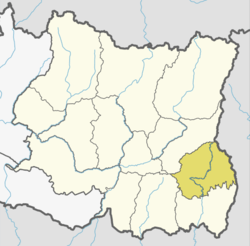
 Sandakpur Location in Province No. 1  Sandakpur Sandakpur (Nepal) | |
| Coordinates: 27.05°N 87.90°E | |
| Province | Province No. 1 |
| District | Ilam |
| Wards | 5 |
| Established | 10 March 2017 |
| Seat | Maipokhari |
| Government | |
| • Type | Village Council |
| • Chairperson | Mr. Udaya Rai (NCP) |
| • Vice-chairperson | Mrs. Sobha Parajuli (NCP) |
| Area | |
| • Total | 156.01 km2 (60.24 sq mi) |
| Elevation | 3,636 m (11,929 ft) |
| Population (2011) | |
| • Total | 16,065 |
| • Density | 100/km2 (270/sq mi) |
| Time zone | UTC+5:45 (Nepal Standard Time) |
| Website | official website |
According to Ministry of Federal Affairs and Local Development Sandakpur has an area of 156.01 square kilometres (60.24 sq mi) and the total population of the municipality is 16065 as of Census of Nepal 2011.[1][2]
Maimajhuwa, Mabu, Sulubung, Maipokhari and Jamuna which previously were all separate Village development committee merged to form this new local level body. Fulfilling the requirement of the new Constitution of Nepal 2015, Ministry of Federal Affairs and Local Development replaced all old VDCs and Municipalities into 753 new local level body (Municipality).[1][3]
The rural municipality is divided into total 5 wards and the headquarter of this newly formed rural municipality is situated in Maipokhari.
References
- "स्थानीय तहहरुको विवरण". www.mofald.gov.np/en. MoFALD. Retrieved 16 April 2018.
- "CITY POPULATION – statistics, maps & charts". www.citypopulation.de. 8 October 2017. Retrieved 16 April 2018.
- "Introduction" [Introduction]. www.sandakpurmun.gov.np (in Nepali). Sandakpur Rural Municipality. Retrieved 15 April 2018.