Letang
Letang, "लेटाङ " is a Municipality in Morang District in the Province No. 1 of south-eastern Nepal. It was formed by merging the existing Village Development Committees of Letang, Janta, Warrangi and Bhogateni. [1]
Letang लेटाङ | |
|---|---|
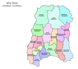 Morang District muncipalities. Letang in center of the northern part | |
 Letang Location in Nepal | |
| Coordinates: 26.72°N 87.50°E | |
| Country | |
| Zone | Koshi Zone |
| District | Morang District |
| Government | |
| • Mayor | Shankar Rai (NC) |
| • Deputy Mayor | Krishna Kumari Pokharel Niraula (NCP) |
| Population (2011) | |
| • Total | 23,907 |
| (10,695 "Male" & 13,212 "Female") | |
| Time zone | UTC+5:45 (NST) |
| Postal code | 56609 |
| Area code(s) | 021 |
| Website | official website |
Location
Letang is in the north of Morang District. It has 9 wards, and an area of 119 square kilometres (46 sq mi).[2]
Letang is situated at the bank of Chisang River. It is located 46 km North east of Biratnagar 394 km east of Kathmandu, at the northern edge of the Terai plain below the Hills. It is a municipality and the urban core of a rapidly growing urban agglomerate in Nepal. It has neighbouring municipalities like Koshi Haraicha, Belbari, Pathari-Sanischare etc.. Letang Municipality is one of the developed municipality of Morang district with various utilities including drinking water, electricity, communication etc.
There is also uneven population distribution in this VDC. Many national politicians, players and film actors such as Babu Bogati, Praween Khatiwada, Ram Bhujel are also from this village. Far more, yearly Rajarani Festival (Mohatshob) is also celebrated by various organizations for its popularity and fame. The villages including Phadani, Budhabare, Kheruwa, Khaireni, Kirtiman, Kamalpur, Lokhra, Kuinkunda, Biran etc. lies here. Among them Letang Bazaar is most developed and Rajarani has religious and tourism importance being old village in Letang.
Population
At the time of the 2011 Nepal census Letang had a population of 18,552 people living in 4,359 individual households.[3] According to 2011 Census, Letang Municipality had a population of 32,035 in 7,339 households. There were 14,350 males and 17,703 females.[2]
Religion and ethnicity
Temples including Rajarani temple (one of the oldest temple of this area), Laxmi Narayan Mandir, Laxmi Panchayan Mandir etc. lies here. The main ethnic groups here are Limbu, Brahmin, Chhetri, Magar, Rai, Tamang etc.
Economy
More than 70% of the people in this VDC are engaged in agriculture.
Education
District-famous schools and campus including Letang Campus, Shanti Bhagawati School Shree Shiksha Vikash M. V. (Kheruwa), Laxmi School, Galaxy Academy, Green Valley School, Minaruwa School, Letang Secondary Boarding School, Bal Niketan School, Pathibhara Boarding School lies here. There is the eastern regional training academy of Nepal Army and also the eastern regional training centre of Agricultural Development Bank, though the bank does not exist nearby.
References
- Brief introduction, Letang Municipality, Office of Municipal Executive, retrieved 2020-06-16
- "Letang Municipality Profile : Facts & Statistics", Nepal Archives, retrieved 2020-06-16
- "Nepal Census 2001". Nepal's Village Development Committees. Digital Himalaya. Archived from the original on October 12, 2008. Retrieved 18 December 2008.
Headquarter: Biratnagar | ||
| Metropolitan City | 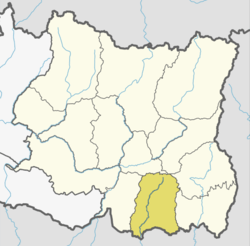 | |
| Municipalities | ||
| Rural Municipalities | ||