Bhojpur, Nepal
Bhojpur (Nepali: भोजपुर) is one of two urban municipalities in Bhojpur District of Province No. 1 of Nepal. It was established on 18 May 2014 merging the existing Bhaisipankha, Bokhim, Bhojpur, Taksar Village Development Committees [1][2] It is the district headquarters of Bhojpur District, a hilly/mountainous district in Province No. 1. At the time of the 2011 Nepal census it had a population of 27204 with an area of 159.51 square kilometres (61.59 sq mi).[3]
Bhojpur Municipality भोजपुर नगरपालिका | |
|---|---|
 Bhojpur Municipality | |
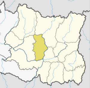
 Bhojpur Municipality Location in Province No. 1  Bhojpur Municipality Bhojpur Municipality (Nepal) | |
| Coordinates: 27°10′N 87°3′E | |
| Country | |
| Province | Province No. 1 |
| District | Bhojpur District |
| Wards | 12 |
| Government | |
| • Mayor | Kailash Kumar Ale (NC) |
| • Deputy Mayor | Mamita Rai (NCP) |
| Area | |
| • Total | 159.51 km2 (61.59 sq mi) |
| Population (2011) | |
| • Total | 27,204 |
| • Density | 170/km2 (440/sq mi) |
| Time zone | NST |
| Postal code | 57000 |
| Area code(s) | 029 |
| GDP (Nominal) | 2017 |
| - Total | RsBillion $Million(Billion, PPP) |
| - per capita | Rs $(PPP) |
| - GDP growth | Moderate (2016) |
| Licence plate prefixes | initiating with Province No 1,Koshi Zone |
| City flower | Rhododendron |
| City trees | Orange, Rudraksha and Amba |
| Climate | Cwb |
| Website | www |
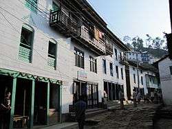
Bhojpiur is the traditional home of Kirat Rai and has its long history since the settlement of the Kirat Rai people. Bhojpur bazaar is famous for its metalwork, particularly khukuri knives. It is home to many businessmen as well as skilled craftsmen. Other major towns in the district include Dingla to the north, Ghoretar to the south, and Taksar near the airstrip, from where flights connect to Biratnagar and Kathmandu.
The design and construction of the 240 km Koshi Highway in east Nepal between Dharan on the Terai Plain and Num in the Middle Himalaya commenced in the early 1970s and was completed in 2012 when the first vehicles were able to drive to Num.[4] Construction of this highway links Bhjopur to other major cities and towns like Hile, Dhankuta and Dharan.
Historically it is a part of Majh Kirat (middle Kirat/ Khambuwan), and used to be called "east number 4". Middle Kirat consists mainly of Bhojpur and Khotang districts, the traditional home of kirat Rai people, an indigenous ethnic group of Nepal. In addition to Rais, other ethnic groups include castes like Chhetris, Bahuns, and Dalits.
People
College & Universities
- Bhojpur Multiple Campus
- Bidhyodaya Higher Secondary School
- PanchaKanya Secondary School
- Yesodhara Higher Secondary School
- Sidheswor Higher Secondary School
- Teachers Training Center
Tourism Spots
- Suntale Danda
- Bhojpur Airport
- Bokhim
- Bhaisipankha
Notable People
- Ram Prasad Rai
- Dayahang Rai
- Bidhya Devi Bhandari
- Babu Bhogati
- Sher Dhan Rai
References
- 72 new municipalities announced Archived June 18, 2014, at the Wayback Machine My Republica
- Govt announces 72 new municipalities The Kathmandu Post
- "स्थानिय तहहरुको विवरण". Ministry of Federal Affairs and Local Development (Nepal). Retrieved 27 March 2018.
- Hearn, G. J. (2017-07-27). "Engineering geomorphology of the Koshi Highway, east Nepal". Quarterly Journal of Engineering Geology and Hydrogeology. 50 (3): qjegh2016–112. doi:10.1144/qjegh2016-112. ISSN 1470-9236.