Miklajung, Morang
Miklajung (Nepali: मिक्लाजुङ गाउँपालिका) is a Gaupalika (rural municipality) located at Morang district.[1][2] Ramite Khola, Jante (Ward No. 3&4), Tandi, and Madhumalla (Ward No.1-6) VDCs were incorporated into Miklajung Gaupalika. This rural municipality has an area of 158.98 sq. km. The population as of 2017 is 28,708. The current VDC Office of Madhumalla is the office of this Gaupalika.[2]
Miklajung Gaupalika | |
|---|---|
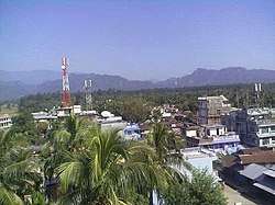 Madhumalla, the centre of Miklajung | |
 Miklajung Gaupalika Miklajung Gaupalika in the map | |
| Coordinates: 26.73°N 87.63°E | |
| country | Nepal |
| Province | Province No. 1 |
| District | Morang District |
| established | 27 Falgun 2073 |
| Government | |
| • Chairperson | Mr. Devi Prasad Acharya (NCP) |
| • Vice-chairperson | Mrs. Sarala Rai (NCP) |
| Area | |
| • Total | 158.98 km2 (61.38 sq mi) |
| Population (2017)[1] | |
| • Total | 28,708 |
| • Density | 180/km2 (470/sq mi) |
| Time zone | UTC+5:45 (Nepal Standard Time) |
| Area code(s) | +977-021 |
| Office | Present Madhumalla VDC Office |
| Website | official website |
References
- "List of Urban and Rural Municipalities of Nepal" (PDF). Ministry of Federal Affairs and Local Development. Retrieved 2017-06-02.
- "हेर्नुहोस्, तपाईं कुन गाउँपालिका वा नगरपालिकामा पर्नुभयो?". setopati. Archived from the original on 2017-03-12. Retrieved Falgun 2073. Check date values in:
|accessdate=(help)
Headquarter: Biratnagar | ||
| Metropolitan City | 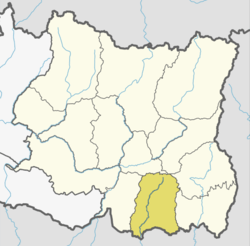 | |
| Municipalities | ||
| Rural Municipalities | ||
This article is issued from Wikipedia. The text is licensed under Creative Commons - Attribution - Sharealike. Additional terms may apply for the media files.