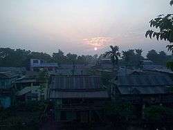
Kanepokhari Rural Municipality
Kanepokhari Rural Municipality (Nepali: कानेपोखरी गाउँपालिका) is a Gaunpalika (rural municipality) located in the center of Morang District, Province No. 1, Nepal.
Kanepokhari | |
|---|---|
 | |
 Kanepokhari wards | |
 Kanepokhari Kanepokhari Gaupalika in Nepal | |
| Coordinates: 26.62°N 87.51°E | |
| country | |
| Province | Province No. 1 |
| District | Morang District |
| established | 27 Falgun 2073 |
| Government | |
| • Chairperson | Mr. Tara Bahadur kaphle (NCP) |
| • Vice-chairperson | Mrs. Rajmati ingnam (NCP) |
| Area | |
| • Total | 82.83 km2 (31.98 sq mi) |
| Population (2017)[1] | |
| • Total | 38,033 |
| • Density | 460/km2 (1,200/sq mi) |
| Time zone | UTC+5:45 (Nepal Standard Time) |
| Area code(s) | + 977-021 |
| Office | Present Bayarban VDC Office |
| Website | kanepokharimun |
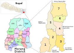
Location
The Bayarban, Keroun and Hoklabari Village development committees were consolidated to form the Kanepokhari Gaupalika in March 2017. This rural municipality has an area of 82.83 square kilometres (31.98 sq mi). The population as of 2017 was 38,033. The current VDC Office of Bayarban is the office of this Gaupalika.[2]
The name comes from the Kanepokhari pond, a site of cultural importance.[3]
Population
According to the 2011 population census, Kanepokhari Rural Municipality had a total population of 38,033, of which 17,487 were male and 20,546 female. There were 8,683 households.[4] The ratio of males to females was 0.85. 5,013 of the population were absent from their households, or 13.18% of the population. The absent people were 4,293 male (24.55% of total) and 720 female (3.5% of total).[4]
Facilities
There are three Banks in this Gaupalika all Located in Kanepokhari Ward 6, Ramailo:
- Miteri Development Bank Limited.
- NIC ASIA Bank Limited.
- Rastriya Banijya Bank Ltd.(Almost Set to open)
The Gaupalika functional Office is Located in Kanepokhari-6, Ramailo.
Wards
There are seven Gram/Nagar Palika wards:[5]
| Ward | Ward Kendra | Households | 2011 Population | Male | Female | Formed from |
|---|---|---|---|---|---|---|
| 1 | VDC Building Bayarban | 1121 | 4830 | 2281 | 2549 | Hoklabari all wards |
| 2 | VDC Building | 1368 | 5941 | 2758 | 3183 | Keroun Wards 3, 4, 6-9 |
| 3 | Jayanepal Chowk | 1174 | 5232 | 2449 | 2783 | Bayarban Wards 1-5 |
| 4 | Bayarban Bajar | 1174 | 5242 | 2363 | 2879 | Bayarban Wards 6, 7 |
| 5 | Bhousabari | 1558 | 6776 | 3107 | 3669 | Keroun Wards 1, 2, 5 |
| 6 | VDC Building | 1340 | 5771 | 2613 | 3158 | Bayarban Ward 8 |
| 7 | Aitabare Bajar | 948 | 4241 | 1916 | 2325 | Bayarban Ward 9 |
References
- "List of Urban and Rural Municipalities of Nepal" (PDF). Ministry of Federal Affairs and Local Development. Retrieved 2017-06-02.
- "हेर्नुहोस्, तपाईं कुन गाउँपालिका वा नगरपालिकामा पर्नुभयो?". setopati. Archived from the original on 12 March 2017. Retrieved 15 June 2017.
- "Kanepokhari drying up for the first time ever", The Rising Nepal, 14 May 2019, retrieved 2020-06-12
- "Kanepokhari Rural Municipality Profile : Facts & Statistics", Nepal Archives, retrieved 2020-06-12
- Unit-9: Kanepokhari Gaunpalika (PDF), District Coordination Committee Office : Morang, Nepal, p. 10, retrieved 2020-06-10