Batchawana Bay
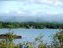
Batchawana Bay is a small bay in Algoma District in Northeastern Ontario, Canada.[1][2][3][4] It is on the eastern shore of Lake Superior, approximately 50 kilometres (31 mi) north of Sault Ste. Marie. Batchawana Bay is also the name of an Batchawana Bay was termed Badjiwanung by the Ojibwe, referring to water that bubbles up. This occurs between Batchawana Island and Sand Point, where the lake narrows and a strong current and undertow results. The Ojibwe believed this was caused by an underwater spirit about to surface.[5]
| Batchawana Bay | |
|---|---|
 | |
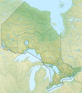 Batchawana Bay Location in Ontario | |
| Location | Algoma District, Ontario |
| Coordinates | 46°52′55″N 84°28′59″W[1] |
| Etymology | Badjiwanung Ojibwe for "water that bubbles up" |
| Part of | Lake Superior |
| Primary inflows | Batchawana River |
| Basin countries | Canada |
Batchawana Bay was an important fishing site for the Ojibwe, and later for the North West Company. The Hudson's Bay Company kept an outpost and fishing station at the mouth of the Batchawana River, which flows into the bay. In the early 1920s, the largest fish ever recorded in the Great Lakes was caught by Frank Lapoint in the bay. A sturgeon, it was reportedly 90 years old, measured 2.25 m (7.5 ft) and weighed 140 kg (310 lb).[5]
The bay is formed on the north side by the Whitefish Point on the Canadian side of Lake Superior and divided from the Haviland and Harmony Bays by Batchawana Island. Batchawana Island and Whitefish Point are both of which are important routes and stopovers for migratory birds. Batchawana island was also reputedly the site of Spirit houses (elevated graves) of the Ojibwe.[5]
The bay was historically notable as the dividing point separating the two Robinson Treaty areas between the Crown and the Ojibwe people.
Batchawana Bay Provincial Park is located on the western shore of the bay,[6][7] and the unincorporated place and Compact Rural Community of Batchawana Bay is on the northwest shore of the bay.[8] The community is on Highway 563.
Nearby Batchawana Mountain (47°03′55″N 84°24′39″W) is the fourth highest point in Ontario at 653 metres (2,142 ft).[9][10]
See also
- Goulais Bay - adjacent bay to the south
References
- "Batchawana Bay". Geographical Names Data Base. Natural Resources Canada. Retrieved 2018-07-01. (bay)
- "CLAIMaps IV". Ontario Ministry of Northern Development and Mines. 2016. Retrieved 2018-07-01.
- Map 12 (PDF) (Map). 1 : 1,600,000. Official road map of Ontario. Ministry of Transportation of Ontario. 2016-01-01. Retrieved 2018-07-01.
- Restructured municipalities - Ontario map #4 (Map). Restructuring Maps of Ontario. Ontario Ministry of Municipal Affairs and Housing. 2006. Retrieved 2018-07-01.
- Chisholm, Barbara; Gutsche, Andrea; Floren, Russell (1998). Superior: Under the Shadow of the Gods. Toronto: Lynx Images. pp. 28–29. ISBN 978-0-9698427-7-4. OCLC 39380117.
- "Batchawana Bay Provincial Park". Geographical Names Data Base. Natural Resources Canada. Retrieved 2018-07-01. (park)
- "Batchawana Bay". Ontario Parks. Retrieved 2018-07-01.
- "Batchawana Bay". Geographical Names Data Base. Natural Resources Canada. Retrieved 2018-07-01. (unincorporated place)
- "Batchawana Mountain". Geographical Names Data Base. Natural Resources Canada. Retrieved 2018-07-01. (mountain)
- "Mountains". Atlas of Canada. Natural Resources Canada. 2009-08-12. Archived from the original on 2011-07-15. Retrieved 2010-07-01.
| Wikimedia Commons has media related to Batchawana Bay. |
Great Lakes of North America | ||
|---|---|---|
| Main lakes |  | |
| Secondary lakes | ||
| Bays and Waterways |
| |
| Islands | ||
| Historic geology | ||
| Government |
| |
| Related topics | ||