Saint-Dalmas-le-Selvage
Saint-Dalmas-le-Selvage is a commune in the Alpes-Maritimes department in southeastern France.
Saint-Dalmas-le-Selvage | |
|---|---|
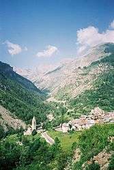 A general view of the village | |
 Coat of arms | |
Location of Saint-Dalmas-le-Selvage 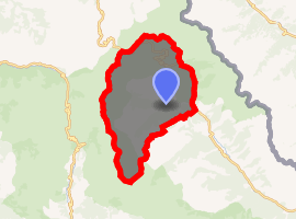
| |
 Saint-Dalmas-le-Selvage  Saint-Dalmas-le-Selvage | |
| Coordinates: 44°17′06″N 6°52′39″E | |
| Country | France |
| Region | Provence-Alpes-Côte d'Azur |
| Department | Alpes-Maritimes |
| Arrondissement | Nice |
| Canton | Tourrette-Levens |
| Intercommunality | Métropole Nice Côte d'Azur |
| Government | |
| • Mayor (2008–2014) | Jean-Pierre Issautier |
| Area 1 | 81.03 km2 (31.29 sq mi) |
| Population (2017-01-01)[1] | 118 |
| • Density | 1.5/km2 (3.8/sq mi) |
| Time zone | UTC+01:00 (CET) |
| • Summer (DST) | UTC+02:00 (CEST) |
| INSEE/Postal code | 06119 /06660 |
| Elevation | 1,280–2,881 m (4,199–9,452 ft) (avg. 1,480 m or 4,860 ft) |
| 1 French Land Register data, which excludes lakes, ponds, glaciers > 1 km2 (0.386 sq mi or 247 acres) and river estuaries. | |
Population
| Historical population | ||
|---|---|---|
| Year | Pop. | ±% |
| 1793 | 550 | — |
| 1800 | 735 | +33.6% |
| 1806 | 710 | −3.4% |
| 1822 | 780 | +9.9% |
| 1838 | 785 | +0.6% |
| 1848 | 721 | −8.2% |
| 1858 | 372 | −48.4% |
| 1861 | 505 | +35.8% |
| 1866 | 497 | −1.6% |
| 1872 | 461 | −7.2% |
| 1876 | 398 | −13.7% |
| 1881 | 313 | −21.4% |
| 1886 | 310 | −1.0% |
| 1891 | 270 | −12.9% |
| 1896 | 277 | +2.6% |
| 1901 | 242 | −12.6% |
| 1906 | 241 | −0.4% |
| 1911 | 213 | −11.6% |
| 1921 | 181 | −15.0% |
| 1926 | 193 | +6.6% |
| 1931 | 187 | −3.1% |
| 1936 | 270 | +44.4% |
| 1946 | 139 | −48.5% |
| 1954 | 115 | −17.3% |
| 1962 | 133 | +15.7% |
| 1968 | 152 | +14.3% |
| 1975 | 151 | −0.7% |
| 1982 | 121 | −19.9% |
| 1990 | 114 | −5.8% |
| 1999 | 123 | +7.9% |
| 2008 | 132 | +7.3% |
References
- "Populations légales 2017". INSEE. Retrieved 6 January 2020.
| Wikimedia Commons has media related to Saint-Dalmas-le-Selvage. |
| Authority control |
|
|---|
This article is issued from Wikipedia. The text is licensed under Creative Commons - Attribution - Sharealike. Additional terms may apply for the media files.